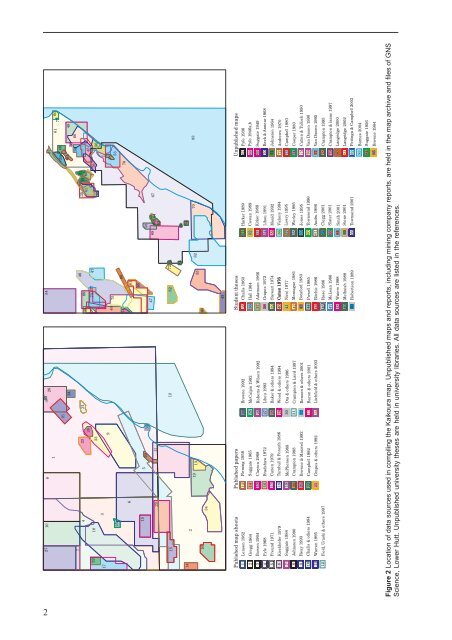
27 1072218172581436233332262124312895439 697340 75744635 714137 474244808171507576177 6059 4951483836 6645795678537615295201130478568586263656467151252 72 8414162341913435584828484708343Published map sheets Published papers1 Lensen 196213 Fleming 195823456789101112Gregg 1964Bowen 1964Fyfe 1968Freund 1971Kieckhefer 1979Suggate 1984Johnston 1990Reay 1993Challis & o<strong>the</strong>rs 1994Warren 1995Field, Uruski & o<strong>the</strong>rs 199714151617181920212223Suggate 1965Clayton 1968Bradshaw 1972Cutten 1979Turnbull & Forsyth 1986McPherson 1988Crampton 1988Browne & Maxwell 1992Campbell 1992Grapes & o<strong>the</strong>rs 19922425262728293031323334Browne 1992McCalpin 1992Roberts & Wilson 1992Lihou 1993Baker & o<strong>the</strong>rs 1994Wood & o<strong>the</strong>rs 1994Ota & o<strong>the</strong>rs 1996Crampton & Laird 1997Benson & o<strong>the</strong>rs 2001Bacon & o<strong>the</strong>rs 2001Litchfield & o<strong>the</strong>rs 2003Student <strong>the</strong>ses Unpublished maps35363738394041424344454647484950Challis 1960Hall 1964Adamson 1966Grapes 1972Stewart 1974Cutten 1976Nicol 1977Montague 1981Botsford 1983Powell 1985Ritchie 1986Rose 1986McLean 1986Waters 1988Melhuish 1988Robertson 198951525354555657585960616263646566Harker 1989Cowan 1989Kirker 1989Lihou 1991Mould 1992Vickery 1994Lowry 1995Worley 1995Jones 1995Townsend 1996Audru 1996Clegg 2001Slater 2001Smith 2001Stone 2001Townsend 200167686970717273747576777879808182Fyfe 1936Fyfe 1946a,bSuggate 1949Beck & Annear 1968Johnston 1964Andrews 1970Campbell 1980Cooper 1980Cutten & Tulloch 1990Van Dissen 1990Van Dissen 1995Crampton 1995Crampton & Isaac 1997Langridge 2000Langridge 2002Pettinga & Campbell 200383 Barnes 200484 Suggate 195685Browne 1984Figure 2 Location <strong>of</strong> data sources used in compiling <strong>the</strong> <strong>Kaikoura</strong> map. Unpublished maps and reports, including mining company reports, are held in <strong>the</strong> map archive and files <strong>of</strong> <strong>GNS</strong><strong>Science</strong>, Lower Hutt. Unpublished university <strong>the</strong>ses are held in university libraries. All data sources are listed in <strong>the</strong> references.2
REGIONAL SETTINGThe <strong>Kaikoura</strong> geological map covers much <strong>of</strong> nor<strong>the</strong>rnCanterbury, sou<strong>the</strong>rn Marlborough and sou<strong>the</strong>rn Nelson,including many <strong>of</strong> <strong>the</strong> nor<strong>the</strong>astern mountains <strong>of</strong> <strong>the</strong> SouthIsland. The map area is sparsely populated with <strong>the</strong> largesttowns – <strong>Kaikoura</strong>, Hanmer and Murchison – servicingagricultural industries. The o<strong>the</strong>r main industries aretourism, fishing and exotic forestry. Much <strong>of</strong> <strong>the</strong>northwestern part <strong>of</strong> <strong>the</strong> <strong>Kaikoura</strong> map area is covered inindigenous forest and is under Department <strong>of</strong> Conservation(DoC) stewardship. DoC administers Nelson Lakes andKahurangi national parks, Lewis Pass Scenic Reserve,Victoria, Hanmer and Lake Sumner conservation parks, MtRichmond Forest Park and Molesworth Farm Park.The <strong>Kaikoura</strong> map area straddles <strong>the</strong> boundary between<strong>the</strong> Australian and Pacific plates which are converging atabout 40 mm per year (Fig. 1). This area also covers <strong>the</strong>plate boundary transition from subduction <strong>of</strong> <strong>the</strong> Pacificplate under <strong>the</strong> Australian plate (Fig. 3), exemplified in <strong>the</strong>sou<strong>the</strong>rn North Island, to continental collision between<strong>the</strong> plates, manifest by uplift <strong>of</strong> <strong>the</strong> Sou<strong>the</strong>rn Alps ando<strong>the</strong>r ranges <strong>of</strong> <strong>the</strong> South Island. Much <strong>of</strong> <strong>the</strong> plateboundary movement in <strong>the</strong> <strong>Kaikoura</strong> map area isaccommodated by oblique, dextral strike-slip along <strong>the</strong>Alpine Fault and <strong>the</strong> Awatere, Clarence, Hope and o<strong>the</strong>rfaults <strong>of</strong> <strong>the</strong> Marlborough Fault System (Van Dissen &Yeats 1991; Knuepfer 1992; Holt & Haines 1995).The basement geology <strong>of</strong> <strong>the</strong> <strong>Kaikoura</strong> map is dominatedby quartz<strong>of</strong>eldspathic sedimentary rocks <strong>of</strong> <strong>the</strong> Rakaia andPahau terranes (Bradshaw 1989), <strong>of</strong> dominantly Mesozoicage, that amalgamated to form <strong>the</strong> Torlesse compositeterrane (Fig. 4). Northwest <strong>of</strong> <strong>the</strong> Alpine Fault <strong>the</strong> basementrocks include <strong>the</strong> early Paleozoic sedimentary andvolcanogenic rocks <strong>of</strong> <strong>the</strong> Buller and Takaka terranes(Cooper 1989), and mid-Paleozoic to Early Cretaceousigneous intrusions <strong>of</strong> <strong>the</strong> Karamea and Median batholiths(Tulloch 1988; Mortimer & o<strong>the</strong>rs 1999). The Permian toJurassic volcanic and sedimentary Brook Street, Murihiku,Dun Mountain-Maitai and Caples terranes occur in southNelson.Covering mid- and Late Cretaceous, Paleogene andNeogene sedimentary rocks have been mostly removedby erosion, particularly in <strong>the</strong> central part <strong>of</strong> <strong>the</strong> map area.The sedimentary rocks resulted from an initial period <strong>of</strong>widespread erosion followed by marine transgression andsubsequent regression in <strong>the</strong> early to middle Cenozoic.The Neogene development <strong>of</strong> <strong>the</strong> modern plate boundarythrough New Zealand, and associated convergence,resulted in uplift and fur<strong>the</strong>r erosion. WidespreadQuaternary terrestrial sedimentation reflects continuinguplift and erosion, with glaciation having a major influenceon sedimentation.Australian PlateHikurangi Trough(oceanic crust)PacificPlateChatham Rise(continental crust)?NHopeFaultClarenceFaultAlpineFaultAwatereFaultsubductingoceaniccrustDepth (km)0-1717-3030-4545-7070-9595-120120-150150-180180-210>210Figure 3 Block model <strong>of</strong> <strong>the</strong> <strong>Kaikoura</strong> map area and surrounding regions showing active faults at <strong>the</strong> surface and <strong>the</strong>position <strong>of</strong> <strong>the</strong> subducting Pacific Plate under <strong>the</strong> Australian Plate defined by earthquake hypocentres (mostlyconcentrated on <strong>the</strong> upper surface <strong>of</strong> <strong>the</strong> subducting plate). After Barnes (1994b), Eberhart-Phillips & Reyners (1997).3
- Page 1: 1 : 2 5 0 0 0 0 G e o l o g i c a l
- Page 7: ABSTRACTThe Kaikoura 1:250 000 geol
- Page 12 and 13: ProvinceSEDIMENTARY AND VOLCANIC RO
- Page 14 and 15: Main Divide rangesGEOMORPHOLOGYThe
- Page 16 and 17: Figure 9 Basin and range topography
- Page 18 and 19: Figure 12 The active Alpine (Wairau
- Page 20 and 21: 290PermianCarboniferous354Late Devo
- Page 22 and 23: iotite granite, locally with megacr
- Page 24: interlayered with the Rotoroa Compl
- Page 28 and 29: Figure 19 Maitai Group sedimentary
- Page 30 and 31: Torlesse composite terraneThe Torle
- Page 32 and 33: Permian to Late Triassic semischist
- Page 34: Zones of intra-Pahau mélange, char
- Page 37 and 38: CRETACEOUS TO PLIOCENEFollowing ama
- Page 39 and 40: Figure 31 Interbedded sandstone and
- Page 41 and 42: Figure 34 The Seymour Group include
- Page 43 and 44: of feldspar-clinopyroxene-biotite-a
- Page 45 and 46: The Amuri Limestone (Pza, Eza) is w
- Page 47 and 48: overlies older rocks (Carter & Land
- Page 49 and 50: Late Miocene to earliest Late Plioc
- Page 51 and 52: QUATERNARYThe tectonic regime initi
- Page 53 and 54: Figure 52 Screes on the southern fl
- Page 55 and 56: Marine depositsMarine sand and grav
- Page 57 and 58: and/or non-deposition (including th
- Page 59 and 60: hydrous mica clay are widespread as
- Page 61 and 62:
Dunite boulders are sporadically co
- Page 63 and 64:
GEOLOGICAL HAZARDSParts of the Kaik
- Page 65 and 66:
The Modified Mercalli Intensity sca
- Page 67 and 68:
Table 2. Mean return periods for ea
- Page 69 and 70:
REFERENCESAdams, C.J. 2003: K-Ar ge
- Page 71 and 72:
Childerhouse, S.J.; Dawson, S.M.; S
- Page 73 and 74:
Holdaway, R.N.; Worthy, T.H. 1997:
- Page 75 and 76:
McPherson, R.I. 1988: Experimental
- Page 77 and 78:
Stewart, R.B. 1974: Geology of Mt M
- Page 79:
This map and text illustrate the ge