Geology of the Kaikoura Area - GNS Science
Geology of the Kaikoura Area - GNS Science
Geology of the Kaikoura Area - GNS Science
- No tags were found...

You also want an ePaper? Increase the reach of your titles
YUMPU automatically turns print PDFs into web optimized ePapers that Google loves.
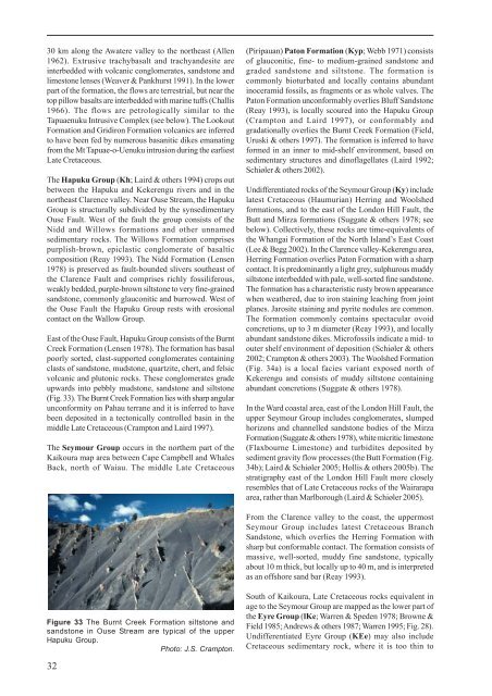
30 km along <strong>the</strong> Awatere valley to <strong>the</strong> nor<strong>the</strong>ast (Allen1962). Extrusive trachybasalt and trachyandesite areinterbedded with volcanic conglomerates, sandstone andlimestone lenses (Weaver & Pankhurst 1991). In <strong>the</strong> lowerpart <strong>of</strong> <strong>the</strong> formation, <strong>the</strong> flows are terrestrial, but near <strong>the</strong>top pillow basalts are interbedded with marine tuffs (Challis1966). The flows are petrologically similar to <strong>the</strong>Tapuaenuku Intrusive Complex (see below). The LookoutFormation and Gridiron Formation volcanics are inferredto have been fed by numerous basanitic dikes emanatingfrom <strong>the</strong> Mt Tapuae-o-Uenuku intrusion during <strong>the</strong> earliestLate Cretaceous.The Hapuku Group (Kh; Laird & o<strong>the</strong>rs 1994) crops outbetween <strong>the</strong> Hapuku and Kekerengu rivers and in <strong>the</strong>nor<strong>the</strong>ast Clarence valley. Near Ouse Stream, <strong>the</strong> HapukuGroup is structurally subdivided by <strong>the</strong> synsedimentaryOuse Fault. West <strong>of</strong> <strong>the</strong> fault <strong>the</strong> group consists <strong>of</strong> <strong>the</strong>Nidd and Willows formations and o<strong>the</strong>r unnamedsedimentary rocks. The Willows Formation comprisespurplish-brown, epiclastic conglomerate <strong>of</strong> basalticcomposition (Reay 1993). The Nidd Formation (Lensen1978) is preserved as fault-bounded slivers sou<strong>the</strong>ast <strong>of</strong><strong>the</strong> Clarence Fault and comprises richly fossiliferous,weakly bedded, purple-brown siltstone to very fine-grainedsandstone, commonly glauconitic and burrowed. West <strong>of</strong><strong>the</strong> Ouse Fault <strong>the</strong> Hapuku Group rests with erosionalcontact on <strong>the</strong> Wallow Group.East <strong>of</strong> <strong>the</strong> Ouse Fault, Hapuku Group consists <strong>of</strong> <strong>the</strong> BurntCreek Formation (Lensen 1978). The formation has basalpoorly sorted, clast-supported conglomerates containingclasts <strong>of</strong> sandstone, mudstone, quartzite, chert, and felsicvolcanic and plutonic rocks. These conglomerates gradeupwards into pebbly mudstone, sandstone and siltstone(Fig. 33). The Burnt Creek Formation lies with sharp angularunconformity on Pahau terrane and it is inferred to havebeen deposited in a tectonically controlled basin in <strong>the</strong>middle Late Cretaceous (Crampton and Laird 1997).The Seymour Group occurs in <strong>the</strong> nor<strong>the</strong>rn part <strong>of</strong> <strong>the</strong><strong>Kaikoura</strong> map area between Cape Campbell and WhalesBack, north <strong>of</strong> Waiau. The middle Late Cretaceous(Piripauan) Paton Formation (Kyp; Webb 1971) consists<strong>of</strong> glauconitic, fine- to medium-grained sandstone andgraded sandstone and siltstone. The formation iscommonly bioturbated and locally contains abundantinoceramid fossils, as fragments or as whole valves. ThePaton Formation unconformably overlies Bluff Sandstone(Reay 1993), is locally scoured into <strong>the</strong> Hapuku Group(Crampton and Laird 1997), or conformably andgradationally overlies <strong>the</strong> Burnt Creek Formation (Field,Uruski & o<strong>the</strong>rs 1997). The formation is inferred to haveformed in an inner to mid-shelf environment, based onsedimentary structures and din<strong>of</strong>lagellates (Laird 1992;Schiøler & o<strong>the</strong>rs 2002).Undifferentiated rocks <strong>of</strong> <strong>the</strong> Seymour Group (Ky) includelatest Cretaceous (Haumurian) Herring and Woolshedformations, and to <strong>the</strong> east <strong>of</strong> <strong>the</strong> London Hill Fault, <strong>the</strong>Butt and Mirza formations (Suggate & o<strong>the</strong>rs 1978; seebelow). Collectively, <strong>the</strong>se rocks are time-equivalents <strong>of</strong><strong>the</strong> Whangai Formation <strong>of</strong> <strong>the</strong> North Island’s East Coast(Lee & Begg 2002). In <strong>the</strong> Clarence valley-Kekerengu area,Herring Formation overlies Paton Formation with a sharpcontact. It is predominantly a light grey, sulphurous muddysiltstone interbedded with pale, well-sorted fine sandstone.The formation has a characteristic rusty brown appearancewhen wea<strong>the</strong>red, due to iron staining leaching from jointplanes. Jarosite staining and pyrite nodules are common.The formation commonly contains spectacular ovoidconcretions, up to 3 m diameter (Reay 1993), and locallyabundant sandstone dikes. Micr<strong>of</strong>ossils indicate a mid- toouter shelf environment <strong>of</strong> deposition (Schiøler & o<strong>the</strong>rs2002; Crampton & o<strong>the</strong>rs 2003). The Woolshed Formation(Fig. 34a) is a local facies variant exposed north <strong>of</strong>Kekerengu and consists <strong>of</strong> muddy siltstone containingabundant concretions (Suggate & o<strong>the</strong>rs 1978).In <strong>the</strong> Ward coastal area, east <strong>of</strong> <strong>the</strong> London Hill Fault, <strong>the</strong>upper Seymour Group includes conglomerates, slumpedhorizons and channelled sandstone bodies <strong>of</strong> <strong>the</strong> MirzaFormation (Suggate & o<strong>the</strong>rs 1978), white micritic limestone(Flaxbourne Limestone) and turbidites deposited bysediment gravity flow processes (<strong>the</strong> Butt Formation (Fig.34b); Laird & Schiøler 2005; Hollis & o<strong>the</strong>rs 2005b). Thestratigraphy east <strong>of</strong> <strong>the</strong> London Hill Fault more closelyresembles that <strong>of</strong> Late Cretaceous rocks <strong>of</strong> <strong>the</strong> Wairarapaarea, ra<strong>the</strong>r than Marlborough (Laird & Schiøler 2005).From <strong>the</strong> Clarence valley to <strong>the</strong> coast, <strong>the</strong> uppermostSeymour Group includes latest Cretaceous BranchSandstone, which overlies <strong>the</strong> Herring Formation withsharp but conformable contact. The formation consists <strong>of</strong>massive, well-sorted, muddy fine sandstone, typicallyabout 10 m thick, but locally up to 40 m, and is interpretedas an <strong>of</strong>fshore sand bar (Reay 1993).Figure 33 The Burnt Creek Formation siltstone andsandstone in Ouse Stream are typical <strong>of</strong> <strong>the</strong> upperHapuku Group.Photo: J.S. Crampton.32South <strong>of</strong> <strong>Kaikoura</strong>, Late Cretaceous rocks equivalent inage to <strong>the</strong> Seymour Group are mapped as <strong>the</strong> lower part <strong>of</strong><strong>the</strong> Eyre Group (lKe; Warren & Speden 1978; Browne &Field 1985; Andrews & o<strong>the</strong>rs 1987; Warren 1995; Fig. 28).Undifferentiated Eyre Group (KEe) may also includeCretaceous sedimentary rock, where it is too thin to