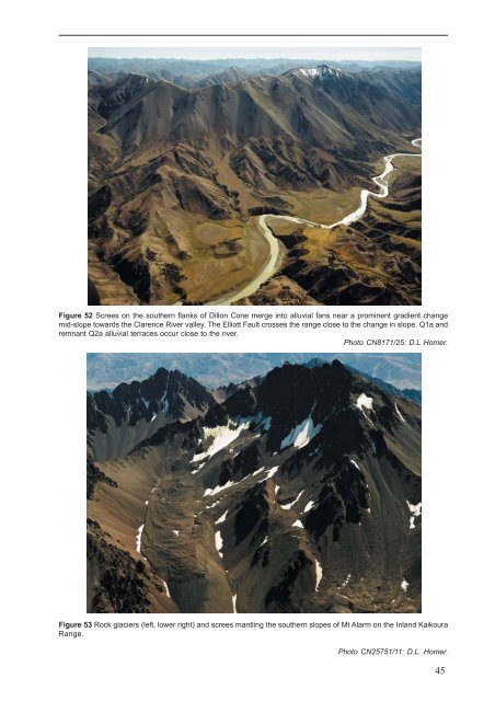
predominant rock type but in <strong>the</strong> northwest, granite andultramafic clasts are locally present. Lenses <strong>of</strong> silt and sandare also present throughout <strong>the</strong> gravel deposits but arerarely significant.Except on present-day floodplains, <strong>the</strong> alluvial depositsform flights <strong>of</strong> aggradational terraces, with <strong>the</strong> older terracespreserved at progressively higher levels above <strong>the</strong> valleyfloors. Although stratigraphic or glacial episode nameshave been applied in local settings (Suggate 1965; Eden1989; Townsend 2001), <strong>the</strong> deposits are differentiated hereby age based on oxygen isotope stages (OIS). Mostdeposits are poorly dated and <strong>the</strong>ir ages are generally basedon <strong>the</strong> height <strong>of</strong> <strong>the</strong> capping terrace surface relative too<strong>the</strong>rs in <strong>the</strong> valley. The extent <strong>of</strong> terrace dissection, degree<strong>of</strong> clast wea<strong>the</strong>ring and <strong>the</strong> number and thickness <strong>of</strong> loessunits (see below) have also helped to constrain terracedeposit ages.The Plateau Gravel (eQl) occurs as isolated remnants thatoverlie <strong>the</strong> Dun Mountain Ultramafics Group on <strong>the</strong> crest<strong>of</strong> Red Hills Ridge (Fig. 17). The formation is up to 25 mthick and comprises poorly sorted and weakly stratifiedultramafic clasts, commonly less than 0.5 m across butwith large angular blocks near <strong>the</strong> base and sparse, wellroundedpebbles <strong>of</strong> Torlesse sandstone. The formationowes its preservation to <strong>the</strong> sandy matrix being cementedby magnesium compounds released from wea<strong>the</strong>ring <strong>of</strong><strong>the</strong> ultramafic rocks. The age <strong>of</strong> <strong>the</strong> gravel is uncertain butis inferred to be no older than Middle Pleistocene (Johnston1990).Unmapped surficial depositsLoess deposits are not differentiated on <strong>the</strong> <strong>Kaikoura</strong> map,but <strong>the</strong>y sometimes form significant sheets up to severalmetres thick on older terraces (Q4 to Q10) adjacent to majorrivers or in gullies in <strong>the</strong> lee <strong>of</strong> <strong>the</strong> prevailing westerlywinds. Identification <strong>of</strong> one or more loess-soil horizons(Fig. 51) may help to broadly distinguish <strong>the</strong> ages <strong>of</strong>aggradation terraces. In <strong>the</strong> nor<strong>the</strong>ast <strong>of</strong> <strong>the</strong> map area, <strong>the</strong>26.5 ka Kawakawa tephra (Oruanui fall deposit; Wilson2001), sourced from <strong>the</strong> central North Island, commonlyoccurs as a layer in loess deposits on terraces older thanOIS 2 and locally in fan gravel deposits (Campbell 1986;Eden 1989; Benson & o<strong>the</strong>rs 2001; Townsend 2001). Thec. 340 ka Rangitawa tephra (Kohn & o<strong>the</strong>rs 1992; Berger &o<strong>the</strong>rs 1994), also from <strong>the</strong> central North Island, occursrarely in loess older than OIS 10 in <strong>the</strong> nor<strong>the</strong>ast <strong>of</strong> <strong>the</strong>map area.Fill, <strong>of</strong> varying levels <strong>of</strong> compaction, is common underroads and railways, particularly in gullies and approachesto bridges. Small areas <strong>of</strong> uncompacted fill, <strong>the</strong> result <strong>of</strong><strong>the</strong> dumping <strong>of</strong> domestic rubbish, are present adjacent tomany <strong>of</strong> <strong>the</strong> townships in <strong>the</strong> map area. All <strong>of</strong> <strong>the</strong>se depositsare too small to show on <strong>the</strong> geological map.Alluvial fan and scree depositsAlluvial fan deposits (Q1a, Q2a, Q3a, Q4a, Q6a, Q8a,Q10a, eQa, uQa) are widespread throughout <strong>the</strong> map areaand many merge into <strong>the</strong> aggradation surfaces in <strong>the</strong> mainvalleys (Fig. 52). Many <strong>of</strong> <strong>the</strong> fans are too small to beshown on <strong>the</strong> map and are ei<strong>the</strong>r omitted or incorporatedinto <strong>the</strong> corresponding alluvial terrace. Mappable screedeposits (Q1s) occur in <strong>the</strong> higher mountains and consist<strong>of</strong> locally derived, slightly wea<strong>the</strong>red, angular clasts <strong>of</strong>pebble to boulder size. Screes commonly merge with moregently sloping, water-borne alluvial fans towards <strong>the</strong> valleyfloors. Rock glacier deposits (Q1r) consisting <strong>of</strong> poorlysorted gravels up to boulder size occur on <strong>the</strong> Inland<strong>Kaikoura</strong> Range (Fig. 53). Eight rock glaciers up to 1.2 kmlength and 500 m wide occur at elevations exceeding 2100m (Bacon & o<strong>the</strong>rs 2001). These are probably activelyexpanding and moving, and result from permafrostconditions in an arid climate where <strong>the</strong>re is a high ratio <strong>of</strong>rock debris to snow supply.Figure 51 Loess on <strong>the</strong> south bank <strong>of</strong><strong>the</strong> Clarence River near SH 1 showingtypical vertical fluting. The faint darkerbanding part way up <strong>the</strong> loess may bea paleosol, or buried soil. Thethickness <strong>of</strong> <strong>the</strong> loess and <strong>the</strong>presence <strong>of</strong> <strong>the</strong> paleosol suggest that<strong>the</strong> age <strong>of</strong> <strong>the</strong> underlying gravel depositis at least OIS 4 (Q4a).44
Figure 52 Screes on <strong>the</strong> sou<strong>the</strong>rn flanks <strong>of</strong> Dillon Cone merge into alluvial fans near a prominent gradient changemid-slope towards <strong>the</strong> Clarence River valley. The Elliott Fault crosses <strong>the</strong> range close to <strong>the</strong> change in slope. Q1a andremnant Q2a alluvial terraces occur close to <strong>the</strong> river.Photo CN8171/25: D.L Homer.Figure 53 Rock glaciers (left, lower right) and screes mantling <strong>the</strong> sou<strong>the</strong>rn slopes <strong>of</strong> Mt Alarm on <strong>the</strong> Inland <strong>Kaikoura</strong>Range.Photo CN25751/11: D.L. Homer.45
- Page 1: 1 : 2 5 0 0 0 0 G e o l o g i c a l
- Page 7: ABSTRACTThe Kaikoura 1:250 000 geol
- Page 10 and 11: 27 10722181725814362333322621243128
- Page 12 and 13: ProvinceSEDIMENTARY AND VOLCANIC RO
- Page 14 and 15: Main Divide rangesGEOMORPHOLOGYThe
- Page 16 and 17: Figure 9 Basin and range topography
- Page 18 and 19: Figure 12 The active Alpine (Wairau
- Page 20 and 21: 290PermianCarboniferous354Late Devo
- Page 22 and 23: iotite granite, locally with megacr
- Page 24: interlayered with the Rotoroa Compl
- Page 28 and 29: Figure 19 Maitai Group sedimentary
- Page 30 and 31: Torlesse composite terraneThe Torle
- Page 32 and 33: Permian to Late Triassic semischist
- Page 34: Zones of intra-Pahau mélange, char
- Page 37 and 38: CRETACEOUS TO PLIOCENEFollowing ama
- Page 39 and 40: Figure 31 Interbedded sandstone and
- Page 41 and 42: Figure 34 The Seymour Group include
- Page 43 and 44: of feldspar-clinopyroxene-biotite-a
- Page 45 and 46: The Amuri Limestone (Pza, Eza) is w
- Page 47 and 48: overlies older rocks (Carter & Land
- Page 49 and 50: Late Miocene to earliest Late Plioc
- Page 51: QUATERNARYThe tectonic regime initi
- Page 55 and 56: Marine depositsMarine sand and grav
- Page 57 and 58: and/or non-deposition (including th
- Page 59 and 60: hydrous mica clay are widespread as
- Page 61 and 62: Dunite boulders are sporadically co
- Page 63 and 64: GEOLOGICAL HAZARDSParts of the Kaik
- Page 65 and 66: The Modified Mercalli Intensity sca
- Page 67 and 68: Table 2. Mean return periods for ea
- Page 69 and 70: REFERENCESAdams, C.J. 2003: K-Ar ge
- Page 71 and 72: Childerhouse, S.J.; Dawson, S.M.; S
- Page 73 and 74: Holdaway, R.N.; Worthy, T.H. 1997:
- Page 75 and 76: McPherson, R.I. 1988: Experimental
- Page 77 and 78: Stewart, R.B. 1974: Geology of Mt M
- Page 79: This map and text illustrate the ge