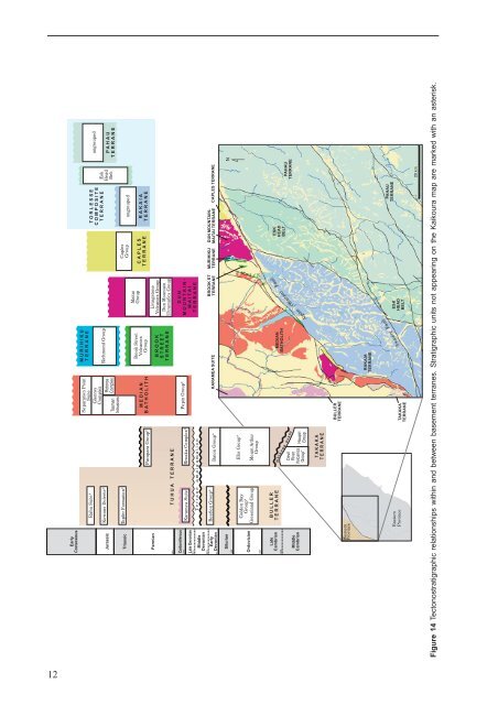
290PermianCarboniferous354Late Devonian370391417EarlyCretaceousJurassicTriassicMiddleDevonianEarlyDevonianRahu Suite*Kirwans Dolerite*Topfer Formation*Karamea SuiteReefton Group*TUHUA TERRANEParapara Group*Riwaka Complex*Terrane amalgamationBaton Group*Separation PointSuiteTasmanIntrusivesGlenroyComplexRotoroaComplexMEDIANBATHOLITHPepin Group*KARAMEA SUITEMURIHIKUTERRANERichmond GroupBrook StreetVolcanicsGroupBROOKSTREETTERRANEMaitaiGroupLivingstoneVolcanics GroupDun MountainUltramafics GroupDUNMOUNTAIN-MAITAITERRANEBROOK STTERRANECaplesGroupCAPLESTERRANEMURIHIKUTERRANETORLESSECOMPOSITETERRANEungroupedRAKAIATERRANEEskHeadBeltDUN MOUNTAIN-MAITAI TERRANE CAPLES TERRANEungroupedPAHAUTERRANE443SilurianNOrdovician490Golden BayGroup*Greenland GroupEllis Group*Mount ArthurGroupm e505LateCambrianMiddleCambrianBULLERTERRANEDevilRiverVolcanicsGroup*l a n g e e v e n tHaupiriGroupMEDIANBATHOLITHESKHEADBELTPAHAUTERRANEine ( rau) ltFauAlp WaiTAKAKATERRANEWesternProvinceBULLERTERRANERAKAIATERRANEEasternProvinceTAKAKATERRANEESKHEADBELTPAHAUTERRANEAwatere Fault20 kmFigure 14 Tectonostratigraphic relationships within and between basement terranes. Stratigraphic units not appearing on <strong>the</strong> <strong>Kaikoura</strong> map are marked with an asterisk.12
STRATIGRAPHYCambrian to Cretaceous basement rocks, includingvolcanic, metasedimentary, granitic and ultramafic rocks,outcrop over 70% <strong>of</strong> <strong>the</strong> <strong>Kaikoura</strong> map area. The basementrocks are overlain by remnants <strong>of</strong> Late Cretaceous andCenozoic, terrestrial and marine, sedimentary and igneousrocks, preserved in basins around Murchison andthroughout eastern Marlborough and nor<strong>the</strong>rn Canterbury.In <strong>the</strong> east <strong>the</strong>se younger rocks contain local volcanicsequences. Quaternary fluvioglacial and alluvial depositsare widespread but Quaternary marine rocks occur onlylocally.CAMBRIAN TO CRETACEOUSThe basement rocks <strong>of</strong> <strong>the</strong> <strong>Kaikoura</strong> map area, <strong>of</strong>Gondwanaland origin, have been divided into <strong>the</strong> largelyearly Paleozoic Western Province and <strong>the</strong> late Paleozoic toMesozoic Eastern Province (Landis & Coombs 1967). Thevolcano-sedimentary and mafic intrusive rocks are mappedin tectonostratigraphic terranes (Figs 4, 14; Coombs &o<strong>the</strong>rs 1976; Bishop & o<strong>the</strong>rs 1985; Bradshaw 1993;Mortimer 2004) within which traditional lithostratigraphicformations and groups are recognised. The WesternProvince contains <strong>the</strong> Buller and Takaka terranes (Cooper1989) that amalgamated in <strong>the</strong> mid-Devonian (collectivelytermed <strong>the</strong> Tuhua composite terrane). The Eastern Provincein <strong>the</strong> <strong>Kaikoura</strong> map area comprises <strong>the</strong> Brook Street, DunMountain-Maitai, Murihiku, and Caples terranes west <strong>of</strong><strong>the</strong> Alpine Fault and <strong>the</strong> Rakaia and Pahau terranes(collectively <strong>the</strong> Torlesse composite terrane) east <strong>of</strong> <strong>the</strong>fault (Coombs & o<strong>the</strong>rs 1976; Mortimer 2004). Many <strong>of</strong> <strong>the</strong>plutonic rocks occur within <strong>the</strong> originally contiguousMedian and Karamea batholiths (Tulloch 1988; Mortimer& o<strong>the</strong>rs 1999).Buller terraneEarly Ordovician sedimentary rocksThe Buller terrane, comprising <strong>the</strong> Greenland Group (|g)within <strong>the</strong> <strong>Kaikoura</strong> map area, occupies a few squarekilometres near Maruia Saddle. The group consists <strong>of</strong> welltopoorly bedded, greenish-grey quartzose sandstone andmudstone (Stewart 1974). The rocks are intruded by LateDevonian-Carboniferous Karamea Suite granite in <strong>the</strong>northwest and faulted against Miocene conglomerate to<strong>the</strong> sou<strong>the</strong>ast. Greenland Group sandstone typicallycontains abundant detrital quartz, minor sodic plagioclaseand subordinate volcanic and sedimentary rock fragments(Nathan 1976; Roser & o<strong>the</strong>rs 1996). The group has beeninterpreted as a turbidite succession within a submarinefan deposit (Laird 1972; Laird & Shelley 1974). Graptolitesfrom near Reefton, 30 km west <strong>of</strong> <strong>the</strong> <strong>Kaikoura</strong> map area,are early Ordovician (Cooper 1974). K-Ar and Rb-Sr agesfrom Greenland Group beyond <strong>the</strong> map area indicate awidespread Late Ordovician to Early Silurian greenschistfacies (chlorite zone) metamorphic event (Adams & o<strong>the</strong>rs1975; Adams 2004). Adjacent to <strong>the</strong> granite, <strong>the</strong> group hasbeen <strong>the</strong>rmally metamorphosed to biotite hornfels (Stewart1974). Metamorphism probably accompanied deformationthat resulted in generally steep bedding dips, tight uprightfolds and a penetrative cleavage (Rattenbury & Stewart2000).Takaka terraneA small area <strong>of</strong> <strong>the</strong> Takaka terrane outcrops in <strong>the</strong> <strong>Kaikoura</strong>map area along <strong>the</strong> Alpine Fault, near Lake Daniells. Fur<strong>the</strong>rnorth <strong>the</strong> terrane is concealed by Tertiary rocks in <strong>the</strong>Murchison Basin (see section C-C’), but is well exposed inNorthwest Nelson, where <strong>the</strong> type localities <strong>of</strong> <strong>the</strong> Haupiriand Mt Arthur groups are located (Rattenbury & o<strong>the</strong>rs1998). Southwest <strong>of</strong> <strong>the</strong> <strong>Kaikoura</strong> map area, <strong>the</strong> terraneprogressively narrows and is truncated by <strong>the</strong> Alpine Fault(Nathan & o<strong>the</strong>rs 2002).Middle Cambrian to Late Ordovician sedimentary rocksIn <strong>the</strong> vicinity <strong>of</strong> Lake Daniells, volcanogenic sedimentaryrocks with conglomerate and minor basaltic flows arecorrelated with <strong>the</strong> Haupiri Group <strong>of</strong> Northwest Nelson(Münker & Cooper 1999; Nathan & o<strong>the</strong>rs 2002). Threeinformal units (Nathan & o<strong>the</strong>rs 2002) are recognised,comprising dolomitic mudstone and ankeritic sandstonewith minor conglomerate ($hr), polymict pebble to granuleconglomerate ($ha), and grey laminated dolomiticmudstone and sandstone with widespread interlayeredfelsic volcanic rocks ($hh). In Northwest Nelson <strong>the</strong> grouphas been assigned a Middle-Late Cambrian age (Münker& Cooper 1999).In <strong>the</strong> Lake Daniells area <strong>the</strong> Mt Arthur Group overlies <strong>the</strong>Haupiri Group (Bowen 1964), separated by a detachmentfault (R. A. Cooper in Nathan & o<strong>the</strong>rs 2002). The SluiceBox Limestone (|ms) consists <strong>of</strong> recrystallised grey,commonly siliceous, limestone and minor sandstone withmudstone layers. Conodonts, trilobites and disarticulatedbrachiopods indicate a Late Cambrian to Middle Ordovicianage (Cooper 1989). The formation is correlated with <strong>the</strong>Arthur Marble 1 and Summit Limestone formations <strong>of</strong>Northwest Nelson (Rattenbury & o<strong>the</strong>rs 1998). Theconformably overlying siltstone and minor quartzsandstone <strong>of</strong> <strong>the</strong> Alfred Formation (|mw) contains LateOrdovician (Gisbornian) graptolites and is correlated with<strong>the</strong> Wangapeka and Baldy formations in Northwest Nelson(Rattenbury & o<strong>the</strong>rs 1998).Karamea BatholithLate Devonian to Early Carboniferous intrusive rocksThe Karamea Batholith extensively intrudes <strong>the</strong> Tuhuaterrane in <strong>the</strong> northwest <strong>of</strong> <strong>the</strong> South Island and isdominated by <strong>the</strong> Karamea Suite <strong>of</strong> Late Devonian-earlyCarboniferous granites (Tulloch 1988; Muir & o<strong>the</strong>rs 1994).The suite has S-type geochemistry, commonly containingmuscovite and generally lacking hornblende. Within <strong>the</strong><strong>Kaikoura</strong> map area <strong>the</strong> rocks are only exposed at MtsNewton and Mantell, north and south <strong>of</strong> Murchisonrespectively, but are inferred to underlie much <strong>of</strong> <strong>the</strong>Paleogene-Miocene strata <strong>of</strong> <strong>the</strong> Murchison Basin. At MtNewton <strong>the</strong> suite comprises coarse-grained, inequigranular13
- Page 1: 1 : 2 5 0 0 0 0 G e o l o g i c a l
- Page 7: ABSTRACTThe Kaikoura 1:250 000 geol
- Page 10 and 11: 27 10722181725814362333322621243128
- Page 12 and 13: ProvinceSEDIMENTARY AND VOLCANIC RO
- Page 14 and 15: Main Divide rangesGEOMORPHOLOGYThe
- Page 16 and 17: Figure 9 Basin and range topography
- Page 18 and 19: Figure 12 The active Alpine (Wairau
- Page 22 and 23: iotite granite, locally with megacr
- Page 24: interlayered with the Rotoroa Compl
- Page 28 and 29: Figure 19 Maitai Group sedimentary
- Page 30 and 31: Torlesse composite terraneThe Torle
- Page 32 and 33: Permian to Late Triassic semischist
- Page 34: Zones of intra-Pahau mélange, char
- Page 37 and 38: CRETACEOUS TO PLIOCENEFollowing ama
- Page 39 and 40: Figure 31 Interbedded sandstone and
- Page 41 and 42: Figure 34 The Seymour Group include
- Page 43 and 44: of feldspar-clinopyroxene-biotite-a
- Page 45 and 46: The Amuri Limestone (Pza, Eza) is w
- Page 47 and 48: overlies older rocks (Carter & Land
- Page 49 and 50: Late Miocene to earliest Late Plioc
- Page 51 and 52: QUATERNARYThe tectonic regime initi
- Page 53 and 54: Figure 52 Screes on the southern fl
- Page 55 and 56: Marine depositsMarine sand and grav
- Page 57 and 58: and/or non-deposition (including th
- Page 59 and 60: hydrous mica clay are widespread as
- Page 61 and 62: Dunite boulders are sporadically co
- Page 63 and 64: GEOLOGICAL HAZARDSParts of the Kaik
- Page 65 and 66: The Modified Mercalli Intensity sca
- Page 67 and 68: Table 2. Mean return periods for ea
- Page 69 and 70: REFERENCESAdams, C.J. 2003: K-Ar ge
- Page 71 and 72:
Childerhouse, S.J.; Dawson, S.M.; S
- Page 73 and 74:
Holdaway, R.N.; Worthy, T.H. 1997:
- Page 75 and 76:
McPherson, R.I. 1988: Experimental
- Page 77 and 78:
Stewart, R.B. 1974: Geology of Mt M
- Page 79:
This map and text illustrate the ge