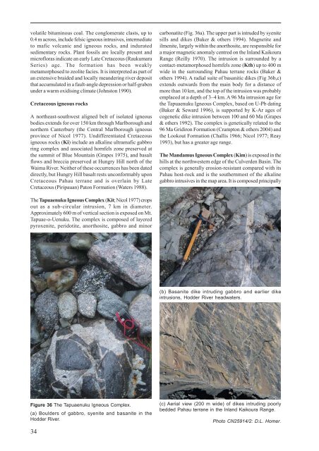
volatile bituminous coal. The conglomerate clasts, up to0.4 m across, include felsic igneous intrusives, intermediateto mafic volcanic and igneous rocks, and induratedsedimentary rocks. Plant fossils are locally present andmicr<strong>of</strong>loras indicate an early Late Cretaceous (RaukumaraSeries) age. The formation has been weaklymetamorphosed to zeolite facies. It is interpreted as part <strong>of</strong>an extensive braided and locally meandering river depositthat accumulated in a fault-angle depression or half-grabenunder a warm oxidising climate (Johnston 1990).Cretaceous igneous rocksA nor<strong>the</strong>ast-southwest aligned belt <strong>of</strong> isolated igneousbodies extends for over 150 km through Marlborough andnor<strong>the</strong>rn Canterbury (<strong>the</strong> Central Marlborough igneousprovince <strong>of</strong> Nicol 1977). Undifferentiated Cretaceousigneous rocks (Ki) include an alkaline ultramafic gabbroring complex and associated hornfels zone preserved at<strong>the</strong> summit <strong>of</strong> Blue Mountain (Grapes 1975), and basaltflows and breccia preserved at Hungry Hill north <strong>of</strong> <strong>the</strong>Waima River. Nei<strong>the</strong>r <strong>of</strong> <strong>the</strong>se occurrences has been dateddirectly, but Hungry Hill basalt rests unconformably uponCretaceous Pahau terrane and is overlain by LateCretaceous (Piripauan) Paton Formation (Waters 1988).carbonatite (Fig. 36a). The upper part is intruded by syenitesills and dikes (Baker & o<strong>the</strong>rs 1994). Magnetite andilmenite, largely within <strong>the</strong> anorthosite, are responsible fora major magnetic anomaly centred on <strong>the</strong> Inland <strong>Kaikoura</strong>Range (Reilly 1970). The intrusion is surrounded by acontact-metamorphosed hornfels zone (Kth) up to 400 mwide in <strong>the</strong> surrounding Pahau terrane rocks (Baker &o<strong>the</strong>rs 1994). A radial suite <strong>of</strong> basanitic dikes (Fig 36b,c)extends outwards from <strong>the</strong> main body for a distance <strong>of</strong>more than 10 km, and <strong>the</strong> top <strong>of</strong> <strong>the</strong> intrusion was probablyemplaced at a depth <strong>of</strong> 3–4 km. A 96 Ma intrusion age for<strong>the</strong> Tapuaenuku Igneous Complex, based on U-Pb dating(Baker & Seward 1996), is supported by K-Ar ages <strong>of</strong>cogenetic dike intrusion between 100 and 60 Ma (Grapes& o<strong>the</strong>rs 1992). The complex is genetically related to <strong>the</strong>96 Ma Gridiron Formation (Crampton & o<strong>the</strong>rs 2004) and<strong>the</strong> Lookout Formation (Challis 1966; Nicol 1977; Reay1993), but has a greater age range.The Mandamus Igneous Complex (Kim) is exposed in <strong>the</strong>hills at <strong>the</strong> northwestern edge <strong>of</strong> <strong>the</strong> Culverden Basin. Thecomplex is generally erosion-resistant compared with itsPahau host-rock and is <strong>the</strong> sou<strong>the</strong>rnmost <strong>of</strong> <strong>the</strong> alkalinegabbro intrusives in <strong>the</strong> map area. It is composed principallyThe Tapuaenuku Igneous Complex (Kit; Nicol 1977) cropsout as a sub-circular intrusion, 7 km in diameter.Approximately 600 m <strong>of</strong> vertical section is exposed on Mt.Tapuae-o-Uenuku. The complex is composed <strong>of</strong> layeredpyroxenite, peridotite, anorthosite, gabbro and minor(b) Basanite dike intruding gabbro and earlier dikeintrusions, Hodder River headwaters.Figure 36 The Tapuaenuku Igneous Complex.(a) Boulders <strong>of</strong> gabbro, syenite and basanite in <strong>the</strong>Hodder River.34(c) Aerial view (200 m wide) <strong>of</strong> dikes intruding poorlybedded Pahau terrane in <strong>the</strong> Inland <strong>Kaikoura</strong> Range.Photo CN25914/2: D.L. Homer.
<strong>of</strong> feldspar-clinopyroxene-biotite-amphibole syenite andclinopyroxene-labradorite-olivine-biotite gabbro. Volcanicflow rocks are predominantly trachytic with minor basalt,including possible vent-lavas/breccias around HurunuiPeak. The Mandamus Igneous Complex has been Rb-Srdated at 97 Ma (Weaver & Pankhurst 1991).Paleocene to Eocene sedimentary rocksIn <strong>the</strong> south <strong>of</strong> <strong>the</strong> <strong>Kaikoura</strong> map area, deposition <strong>of</strong> <strong>the</strong>Eyre Group including Conway Formation and LoburnMudstone (see above) continued through into <strong>the</strong>Paleocene. The upper part <strong>of</strong> <strong>the</strong> Eyre Group is commonlytoo thin to differentiate from lower parts and is mapped asundifferentiated (KEe; Fig. 28). Paleogene Eyre Group (PEe)includes <strong>the</strong> Paleocene to Early Eocene Waipara Greensand,consisting <strong>of</strong> fine- to medium-grained, glauconiticsandstone that becomes increasingly muddy up section(Browne & Field 1985). The overlying Early to MiddleEocene Ashley Mudstone consists <strong>of</strong> glauconitic,calcareous sandy mudstone, siltstone and sandstone. Ingeneral <strong>the</strong> Ashley Formation rests disconformably onWaipara Greensand (commonly with a burrowed,phosphatised contact) but, locally, around <strong>the</strong> lowerHurunui River-Culverden area, it is unconformable onPahau terrane (Fig. 28). In <strong>the</strong> far south <strong>of</strong> <strong>the</strong> <strong>Kaikoura</strong>map area, <strong>the</strong> Middle to Late Eocene Homebush Sandstoneoverlies <strong>the</strong> Ashley Mudstone. It is a massive, glauconitic,unfossiliferous, well-sorted, quartzose sandstone, that mayhave become remobilised or intruded into underlying andoverlying units since deposition (Browne & Field 1985).The environment <strong>of</strong> deposition <strong>of</strong> upper Eyre Group rocksincludes shallow marine, low energy outer shelf (bathyal),and relatively high-energy near-shore beach settings.The Muzzle Group (Reay 1993) consists <strong>of</strong> mainly stronglyindurated micritic limestone and calcareous mudstone,chert, and minor greensand and volcanic rocks. The groupcontains two formations, <strong>the</strong> Mead Hill Formation and <strong>the</strong>Amuri Limestone, and in areas where both formations arethin <strong>the</strong> Muzzle Group is undifferentiated (KPz) on <strong>the</strong>map. The Mead Hill Formation (Kzm; Webb 1971) istypically a greenish-grey, chert-rich, micritic limestone,wea<strong>the</strong>ring to white and black (Fig. 37), with calcareousmudstone and nodular chert. The formation is limited to<strong>the</strong> nor<strong>the</strong>astern part <strong>of</strong> <strong>the</strong> map area and varies greatly inthickness. In Branch Stream it is about 120 m thick but itpinches out in <strong>the</strong> middle Clarence valley and is absent inSeymour Stream (Reay 1993); it reaches its greatestthickness in Mead Stream, where it is over 250 m thick(Strong & o<strong>the</strong>rs 1995). In <strong>the</strong> nor<strong>the</strong>rn Clarence valleyand in coastal eastern Marlborough, <strong>the</strong> formation contains<strong>the</strong> Cretaceous-Paleogene boundary, which is particularlywell exposed in Mead Stream (Fig. 38) and is marked bymajor changes in micr<strong>of</strong>ossil assemblages (see text box).At Mead Stream <strong>the</strong> top <strong>of</strong> <strong>the</strong> formation is as young asLate Paleocene (Strong & o<strong>the</strong>rs 1995; Hollis & o<strong>the</strong>rs2005a).Figure 37 The Mead Hill Formation, MuzzleGroup, is a well-bedded siliceous limestone,shown here in Mead Stream.Figure 38 The Cretaceous-Paleogeneboundary occurs within <strong>the</strong> Mead HillFormation in Mead Stream. The hammerhandle rests on <strong>the</strong> thin bed marking <strong>the</strong>boundary.35
- Page 1: 1 : 2 5 0 0 0 0 G e o l o g i c a l
- Page 7: ABSTRACTThe Kaikoura 1:250 000 geol
- Page 10 and 11: 27 10722181725814362333322621243128
- Page 12 and 13: ProvinceSEDIMENTARY AND VOLCANIC RO
- Page 14 and 15: Main Divide rangesGEOMORPHOLOGYThe
- Page 16 and 17: Figure 9 Basin and range topography
- Page 18 and 19: Figure 12 The active Alpine (Wairau
- Page 20 and 21: 290PermianCarboniferous354Late Devo
- Page 22 and 23: iotite granite, locally with megacr
- Page 24: interlayered with the Rotoroa Compl
- Page 28 and 29: Figure 19 Maitai Group sedimentary
- Page 30 and 31: Torlesse composite terraneThe Torle
- Page 32 and 33: Permian to Late Triassic semischist
- Page 34: Zones of intra-Pahau mélange, char
- Page 37 and 38: CRETACEOUS TO PLIOCENEFollowing ama
- Page 39 and 40: Figure 31 Interbedded sandstone and
- Page 41: Figure 34 The Seymour Group include
- Page 45 and 46: The Amuri Limestone (Pza, Eza) is w
- Page 47 and 48: overlies older rocks (Carter & Land
- Page 49 and 50: Late Miocene to earliest Late Plioc
- Page 51 and 52: QUATERNARYThe tectonic regime initi
- Page 53 and 54: Figure 52 Screes on the southern fl
- Page 55 and 56: Marine depositsMarine sand and grav
- Page 57 and 58: and/or non-deposition (including th
- Page 59 and 60: hydrous mica clay are widespread as
- Page 61 and 62: Dunite boulders are sporadically co
- Page 63 and 64: GEOLOGICAL HAZARDSParts of the Kaik
- Page 65 and 66: The Modified Mercalli Intensity sca
- Page 67 and 68: Table 2. Mean return periods for ea
- Page 69 and 70: REFERENCESAdams, C.J. 2003: K-Ar ge
- Page 71 and 72: Childerhouse, S.J.; Dawson, S.M.; S
- Page 73 and 74: Holdaway, R.N.; Worthy, T.H. 1997:
- Page 75 and 76: McPherson, R.I. 1988: Experimental
- Page 77 and 78: Stewart, R.B. 1974: Geology of Mt M
- Page 79: This map and text illustrate the ge