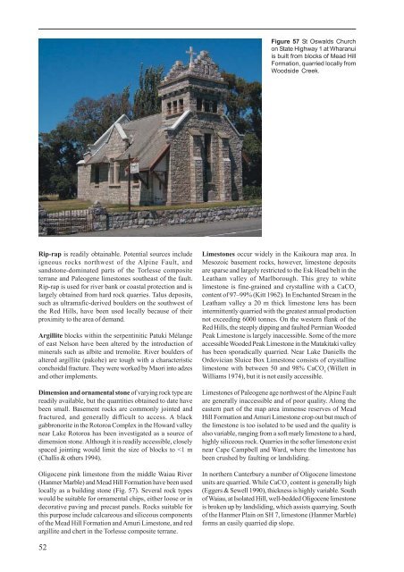
Figure 57 St Oswalds Churchon State Highway 1 at Wharanuiis built from blocks <strong>of</strong> Mead HillFormation, quarried locally fromWoodside Creek.Rip-rap is readily obtainable. Potential sources includeigneous rocks northwest <strong>of</strong> <strong>the</strong> Alpine Fault, andsandstone-dominated parts <strong>of</strong> <strong>the</strong> Torlesse compositeterrane and Paleogene limestones sou<strong>the</strong>ast <strong>of</strong> <strong>the</strong> fault.Rip-rap is used for river bank or coastal protection and islargely obtained from hard rock quarries. Talus deposits,such as ultramafic-derived boulders on <strong>the</strong> southwest <strong>of</strong><strong>the</strong> Red Hills, have been used locally because <strong>of</strong> <strong>the</strong>irproximity to <strong>the</strong> area <strong>of</strong> demand.Argillite blocks within <strong>the</strong> serpentinitic Patuki Mélange<strong>of</strong> east Nelson have been altered by <strong>the</strong> introduction <strong>of</strong>minerals such as albite and tremolite. River boulders <strong>of</strong>altered argillite (pakohe) are tough with a characteristicconchoidal fracture. They were worked by Maori into adzesand o<strong>the</strong>r implements.Dimension and ornamental stone <strong>of</strong> varying rock type arereadily available, but <strong>the</strong> quantities obtained to date havebeen small. Basement rocks are commonly jointed andfractured, and generally difficult to access. A blackgabbronorite in <strong>the</strong> Rotoroa Complex in <strong>the</strong> Howard valleynear Lake Rotoroa has been investigated as a source <strong>of</strong>dimension stone. Although it is readily accessible, closelyspaced jointing would limit <strong>the</strong> size <strong>of</strong> blocks to
Dunite boulders are sporadically collected from streamsdraining from <strong>the</strong> Red Hills into <strong>the</strong> Wairau River for use insaunas and hangi because <strong>the</strong>y withstand rapid coolingwithout explosively disintegrating.CoalCoal occurs locally in rocks <strong>of</strong> Late Cretaceous age andcommonly near <strong>the</strong> base <strong>of</strong> Paleogene sequences. However,<strong>the</strong> only coal <strong>of</strong> economic significance in <strong>the</strong> map area is in<strong>the</strong> Murchison Basin (Suggate 1984). Up to five seamshave been recorded from <strong>the</strong> basal Maruia Formation near<strong>the</strong> lower Matiri valley. Although <strong>the</strong> coal is stronglyswelling and <strong>of</strong> high-volatile bituminous rank, <strong>the</strong> seamshave a maximum thickness <strong>of</strong> only 1.2 m, <strong>the</strong> structure isunfavourable for mining and <strong>the</strong> coal has a medium to highsulphur content. The Longford Formation in <strong>the</strong> lowerMatakitaki and Owen valleys contains several seams <strong>of</strong>low-swelling, low-moisture, high-volatile bituminous coalwith low (c. 1%) sulphur. The seams pinch and swell,reaching a maximum thickness <strong>of</strong> 3 m, and <strong>the</strong> coal iscommonly crushed. The easily accessible coal has beenworked out and, because <strong>of</strong> <strong>the</strong> irregularity <strong>of</strong> <strong>the</strong> seamsand structure, <strong>the</strong> prospects for renewed mining are poor.Total production was probably in <strong>the</strong> order <strong>of</strong> 150 000tonnes (Suggate 1984).WaterGroundwater availability is generally restricted east <strong>of</strong> <strong>the</strong>Main Divide where rainfall is lower and aquifers have limitedextent. The best yields occur in Late Quaternary alluvialgravel, particularly adjacent to <strong>the</strong> major rivers draining<strong>the</strong> hard basement rocks or from <strong>the</strong> fan gravel aprons on<strong>the</strong> flanks <strong>of</strong> <strong>the</strong> major ranges (Brown in Eggers & Sewell1990). In <strong>the</strong> lower Awatere valley, <strong>the</strong> gravels are thin andoverlie Pliocene siltstone <strong>of</strong> low permeability that restrictsriver recharge. In <strong>the</strong> minor rivers and streams, includingthose draining s<strong>of</strong>t and/or wea<strong>the</strong>red rock, an increase infine-grained material in <strong>the</strong> gravel deposits tends to reducepermeability. Along <strong>the</strong> coast, Holocene beach sands anddunes have a high permeability and porosity but rechargein many areas is dependent on frequent rainfall, and overextractioncan result in saline intrusion (Doole & o<strong>the</strong>rs1987; Brown in Eggers & Sewell 1990). The Neogene toPleistocene gravel and sand deposits have generally low,but usually reliable yields.The pre-Quaternary Cenozoic rocks in <strong>the</strong> mapped areagenerally have few open joints, and except along faultplanes and in limestones, groundwater yields are low. Thebasement rocks have numerous joints, particularly alongfault zones, which provide sufficient permeability to yieldsmall quantities <strong>of</strong> groundwater. In some basement rocks,such as schist, igneous and early Paleozoic rocks, <strong>the</strong>presence <strong>of</strong> sulphide minerals tends to reduce water quality.However, where this occurs surface water supplies areabundant.Thermal and mineralised hot springs are widespread,although not common, throughout <strong>the</strong> Sou<strong>the</strong>rn Alps and<strong>the</strong> ranges <strong>of</strong> nor<strong>the</strong>rn Canterbury (Mongillo & Clelland1984). These springs are <strong>the</strong> result <strong>of</strong> groundwaterpercolating to considerable depth along fault zones beforedischarging on valley floors (Barnes & o<strong>the</strong>rs 1978; Allis& o<strong>the</strong>rs 1979). Measured temperatures range from 27.5°Cto 60°C and are commonly accompanied by a sulphurousdischarge (Mongillo & Clelland 1984). Commercial <strong>the</strong>rmalresorts have been developed at Hanmer Springs and MaruiaSprings along <strong>the</strong> Hope and Fowlers faults respectively.Oil and gasOil and gas shows are present in a number <strong>of</strong> places within<strong>the</strong> Murchison Basin. The basin contains approximately9000 m <strong>of</strong> Late Eocene to Miocene sedimentary rocks in itscentre and up to a fur<strong>the</strong>r 3000 m may have been removedby erosion (Nathan & o<strong>the</strong>rs 1986). The basin was drilledin <strong>the</strong> late 1920s and in 1968, 1970 and 1985 although only<strong>the</strong> last hole, Matiri-1, reached bedrock (at 1467 m; Dunn& o<strong>the</strong>rs 1986). The rocks in <strong>the</strong> basin are generally steeplydipping, having been folded into a series <strong>of</strong> synclinesseparated by faulted anticlines. No closed structural trapsare known and <strong>the</strong>re are few potential reservoir rocks withsufficient permeability or porosity, and consequently <strong>the</strong>hydrocarbon prospects are assessed as low (Nathan &o<strong>the</strong>rs 1986).In Marlborough, oil seeps are known from Pahau terranerocks at London Hill and <strong>the</strong> Amuri Limestone in IsolationCreek, south <strong>of</strong> <strong>the</strong> Waima River. Both seeps occur in closeproximity to major faults. The oil is likely to have beensourced from <strong>the</strong> Late Cretaceous Seymour Group and havemigrated up <strong>the</strong> fault zones to <strong>the</strong> surface (Field, Uruski &o<strong>the</strong>rs 1997). While both source rocks and potentialreservoir rocks are favourable, deformation has limited <strong>the</strong>possibility <strong>of</strong> any significant hydrocarbon traps. Mudstoneat <strong>the</strong> base <strong>of</strong> <strong>the</strong> Amuri Limestone in Mead Stream hasbeen correlated with <strong>the</strong> Waipawa Formation, ahydrocarbon source rock in <strong>the</strong> eastern North Island (Field,Uruski & o<strong>the</strong>rs 1997). However, in Marlborough, <strong>the</strong>mudstone is only a few metres thick, and significanthydrocarbon potential from this rock is unlikely.In nor<strong>the</strong>rn Canterbury hydrocarbons have been reportedfrom a number <strong>of</strong> locations, principally in <strong>the</strong> Cheviot area(Field, Browne & o<strong>the</strong>rs 1989). Several seeps occur in <strong>the</strong>Torlesse rocks although <strong>the</strong> hydrocarbons are most likelyto have originated in adjacent Late Cretaceous-Paleogenerocks (e.g., <strong>the</strong> Eyre Group), which include potential sourceand reservoir rocks as well as o<strong>the</strong>r seeps. Significantstructural traps have not yet been identified, and <strong>the</strong>re is<strong>the</strong> potential for stratigraphic traps. Gas containing a veryhigh ethane content escapes from <strong>the</strong> Hanmer <strong>the</strong>rmalsprings (Field, Browne and o<strong>the</strong>rs 1989).The <strong>of</strong>fshore area <strong>of</strong> <strong>the</strong> <strong>Kaikoura</strong> map has had limitedpetroleum exploration but seismic data <strong>of</strong> varying qualityhas identified several deep sedimentary basins (Uruski1992; Field, Uruski & o<strong>the</strong>rs 1997). The basins may containpotential source rocks that have been buried sufficientlyto generate hydrocarbons.53
- Page 1:
1 : 2 5 0 0 0 0 G e o l o g i c a l
- Page 7:
ABSTRACTThe Kaikoura 1:250 000 geol
- Page 10 and 11: 27 10722181725814362333322621243128
- Page 12 and 13: ProvinceSEDIMENTARY AND VOLCANIC RO
- Page 14 and 15: Main Divide rangesGEOMORPHOLOGYThe
- Page 16 and 17: Figure 9 Basin and range topography
- Page 18 and 19: Figure 12 The active Alpine (Wairau
- Page 20 and 21: 290PermianCarboniferous354Late Devo
- Page 22 and 23: iotite granite, locally with megacr
- Page 24: interlayered with the Rotoroa Compl
- Page 28 and 29: Figure 19 Maitai Group sedimentary
- Page 30 and 31: Torlesse composite terraneThe Torle
- Page 32 and 33: Permian to Late Triassic semischist
- Page 34: Zones of intra-Pahau mélange, char
- Page 37 and 38: CRETACEOUS TO PLIOCENEFollowing ama
- Page 39 and 40: Figure 31 Interbedded sandstone and
- Page 41 and 42: Figure 34 The Seymour Group include
- Page 43 and 44: of feldspar-clinopyroxene-biotite-a
- Page 45 and 46: The Amuri Limestone (Pza, Eza) is w
- Page 47 and 48: overlies older rocks (Carter & Land
- Page 49 and 50: Late Miocene to earliest Late Plioc
- Page 51 and 52: QUATERNARYThe tectonic regime initi
- Page 53 and 54: Figure 52 Screes on the southern fl
- Page 55 and 56: Marine depositsMarine sand and grav
- Page 57 and 58: and/or non-deposition (including th
- Page 59: hydrous mica clay are widespread as
- Page 63 and 64: GEOLOGICAL HAZARDSParts of the Kaik
- Page 65 and 66: The Modified Mercalli Intensity sca
- Page 67 and 68: Table 2. Mean return periods for ea
- Page 69 and 70: REFERENCESAdams, C.J. 2003: K-Ar ge
- Page 71 and 72: Childerhouse, S.J.; Dawson, S.M.; S
- Page 73 and 74: Holdaway, R.N.; Worthy, T.H. 1997:
- Page 75 and 76: McPherson, R.I. 1988: Experimental
- Page 77 and 78: Stewart, R.B. 1974: Geology of Mt M
- Page 79: This map and text illustrate the ge