Vickery, S. 1994: Cenozoic deformation <strong>of</strong> <strong>the</strong> Plate-BoundaryZone, Marlborough, New Zealand. PhD <strong>the</strong>sis, University <strong>of</strong>Oxford, England.Vickery, S.; Lamb, S. 1995: Large tectonic rotations since <strong>the</strong>Early Miocene in a convergent plate boundary zone, SouthIsland, New Zealand. Earth and Planetary <strong>Science</strong> Letters 136:44-59.Walcott, R.I. 1969: <strong>Geology</strong> <strong>of</strong> <strong>the</strong> Red Hill Complex, Nelson,New Zealand. Transactions <strong>of</strong> <strong>the</strong> Royal Society <strong>of</strong> New Zealand.Earth <strong>Science</strong>s 7: 57-88.Walcott, R.I. 1978: Present tectonics and late Cenozoic evolution<strong>of</strong> New Zealand. Geophysical Journal <strong>of</strong> <strong>the</strong> Royal AstronomicalSociety 52: 137-164.Walcott, R.I. 1998: Modes <strong>of</strong> oblique compression: late Cenozoictectonics <strong>of</strong> <strong>the</strong> South Island <strong>of</strong> New Zealand. Reviews <strong>of</strong>Geophysics 36: 1-26.Wandres, A.M.; Bradshaw, J.D.; Weaver, S.; Maas, R.; Ireland,T.; Eby, N. 2004: Provenance analysis using conglomerate clastlithologies: a case study from <strong>the</strong> Pahau terrane <strong>of</strong> New Zealand.Sedimentary <strong>Geology</strong> 167: 57-89.Warren, G. 1995: <strong>Geology</strong> <strong>of</strong> <strong>the</strong> Parnassus area. Institute <strong>of</strong>Geological & Nuclear <strong>Science</strong>s geological map 18. Lower Hutt,Institute <strong>of</strong> Geological & Nuclear <strong>Science</strong>s. 36 p + 1 map.Warren, G.; Speden, I.G. 1978: The Piripauan and Haumurianstratotypes (Mata Series, Upper Cretaceous) and correlativesequences in <strong>the</strong> Haumuri Bluff district, south Marlborough(S56). New Zealand Geological Survey Bulletin 92. 60 p.Waterhouse, J.B. 1964: Permian stratigraphy and faunas <strong>of</strong> NewZealand. New Zealand Geological Survey Bulletin 72. 111 p.Waters, D.W. 1988: The Flags Creek Thrust, Marlborough, NewZealand. BSc (Hons) <strong>the</strong>sis (<strong>Geology</strong>), Victoria University <strong>of</strong>Wellington, Wellington.Weaver, S.D.; Pankhurst, R.J. 1991: A precise Rb-Sr age for <strong>the</strong>Mandamus Igneous Complex, North Canterbury, and regionaltectonic implications. New Zealand Journal <strong>of</strong> <strong>Geology</strong> andGeophysics 34: 341-345.Webb, P.N. 1971: New Zealand Late Cretaceous (Haumurian)foraminifera and stratigraphy: a summary. New Zealand Journal<strong>of</strong> <strong>Geology</strong> and Geophysics 14: 795-828.Wellman, H.W. 1953: Note on Maitai and Te Anau rocks inMatakitaki Valley, Nelson (S32). New Zealand Journal <strong>of</strong><strong>Science</strong> and Technology B35(1): 36-37.Wellman, H.W.; Grindley, G.W.; Munden, F.W. 1952: The AlpineSchists and <strong>the</strong> Upper Triassic <strong>of</strong> Harpers Pass (Sheet S52),South Island, New Zealand. Transactions <strong>of</strong> <strong>the</strong> Royal Society<strong>of</strong> New Zealand 80: 213-227.Williams, G.J. 1974: Economic geology <strong>of</strong> New Zealand: <strong>the</strong> T.J.McKee memorial volume. Australasian Institute <strong>of</strong> Mining andMetallurgy monograph series 4. 490 p.Wilson, C.J.N. 2001: The 26.5 ka Oruanui eruption, New Zealand:an introduction and overview. Journal <strong>of</strong> Volcanology andGeo<strong>the</strong>rmal Research 112: 133-174.Wood, R.A.; Pettinga, J.R.; Bannister, S.; Lamarche, G.;McMorran, T.J. 1994: Structure <strong>of</strong> <strong>the</strong> Hanmer strike-slip basin,Hope Fault, New Zealand. Geological Society <strong>of</strong> America Bulletin106: 1459-1473.Worley, S. 1995: Amuri Range <strong>Geology</strong>. MSc <strong>the</strong>sis (<strong>Geology</strong>),University <strong>of</strong> Otago, Dunedin.Worthy, T.H.; Holdaway, R.N. 1995: Quaternary fossil faunasfrom caves on Mt Cookson, North Canterbury, South Island,New Zealand. Journal <strong>of</strong> <strong>the</strong> Royal Society <strong>of</strong> New Zealand 25:333-370.Worthy, T.H.; Holdaway, R.N. 1996: Quaternary fossil faunas,overlapping taphonomies, and palae<strong>of</strong>aunal reconstruction inNorth Canterbury, South Island, New Zealand. Journal <strong>of</strong> <strong>the</strong>Royal Society <strong>of</strong> New Zealand 26: 275-361.Yetton, M.D. 2002: Paleoseismic investigation <strong>of</strong> <strong>the</strong> north andwest Wairau sections <strong>of</strong> <strong>the</strong> Alpine Fault, South Island, NewZealand. EQC research report 99/353. 96 p.70
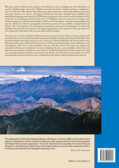
This map and text illustrate <strong>the</strong> geology <strong>of</strong> <strong>the</strong> <strong>Kaikoura</strong> area, extending east from Murchison tosou<strong>the</strong>rn Marlborough, and south to Waikari in north Canterbury. Onshore geology is mapped at ascale <strong>of</strong> 1:250 000 while <strong>of</strong>fshore <strong>the</strong> bathymetry, thick Quaternary sedimentary deposits and majorstructural elements are shown. Geological information has been obtained from published andunpublished mapping and research by <strong>GNS</strong> <strong>Science</strong> geologists, from work by staff and students <strong>of</strong> <strong>the</strong>University <strong>of</strong> Canterbury, Victoria University <strong>of</strong> Wellington and <strong>the</strong> University <strong>of</strong> Otago, from<strong>of</strong>fshore mapping by <strong>the</strong> National Institute <strong>of</strong> Water and Atmosphere, and from mineral explorationreports. All data are held in a geographic information system and are available in digital format onrequest. The accompanying text summarises <strong>the</strong> geology and tectonic development, as well as <strong>the</strong>geological hazards and <strong>the</strong> economic and engineering geology <strong>of</strong> <strong>the</strong> map area. The map is part <strong>of</strong> aseries initiated in 1996 which will cover <strong>the</strong> whole <strong>of</strong> New Zealand.The map area is mostly underlain by Mesozoic greywacke rocks <strong>of</strong> <strong>the</strong> Torlesse terrane, except in <strong>the</strong>northwest where narrow fault-bounded remnants <strong>of</strong> <strong>the</strong> Buller, Takaka, Brook Street, Murihiku, DunMountain-Maitai and Caples terranes occur, as well as <strong>the</strong> Median Batholith and o<strong>the</strong>r granitic rocks.Discontinuously preserved late Early Cretaceous to Pliocene, predominantly marine sedimentary andvolcanogenic rocks occur in <strong>the</strong> northwest, <strong>the</strong> east and <strong>the</strong> south <strong>of</strong> <strong>the</strong> map area. Quaternaryterrestrial sediments are widespread on land, including till, loess, scree, landslide, alluvial fan andalluvial terrace deposits. Numerous active faults <strong>of</strong> <strong>the</strong> Marlborough Fault System transect <strong>the</strong> maparea, marking <strong>the</strong> plate boundary zone between <strong>the</strong> Pacific and Australian tectonic plates. Several <strong>of</strong><strong>the</strong>se faults have moved in historic times contributing to <strong>the</strong> region's relatively high seismic hazard.The highest point <strong>of</strong> <strong>the</strong> Inland <strong>Kaikoura</strong> Range is Mt Tapuae-o-Uenuku (2885 m) where <strong>the</strong> summitregion is composed <strong>of</strong> erosion-resistant Cretaceous mafic igneous intrusive rocks and associatedhornfelsed Pahau terrane greywacke. The active Clarence Fault separates <strong>the</strong> Inland <strong>Kaikoura</strong>Range from <strong>the</strong> distinctive Chalk Range in <strong>the</strong> middle distance, and <strong>the</strong> white screes <strong>the</strong>re and in<strong>the</strong> foreground emanate from Paleogene carbonate rocks.Photo: D.B. TownsendISBN 0-478-09925-8
- Page 1:
1 : 2 5 0 0 0 0 G e o l o g i c a l
- Page 7:
ABSTRACTThe Kaikoura 1:250 000 geol
- Page 10 and 11:
27 10722181725814362333322621243128
- Page 12 and 13:
ProvinceSEDIMENTARY AND VOLCANIC RO
- Page 14 and 15:
Main Divide rangesGEOMORPHOLOGYThe
- Page 16 and 17:
Figure 9 Basin and range topography
- Page 18 and 19:
Figure 12 The active Alpine (Wairau
- Page 20 and 21:
290PermianCarboniferous354Late Devo
- Page 22 and 23:
iotite granite, locally with megacr
- Page 24:
interlayered with the Rotoroa Compl
- Page 28 and 29: Figure 19 Maitai Group sedimentary
- Page 30 and 31: Torlesse composite terraneThe Torle
- Page 32 and 33: Permian to Late Triassic semischist
- Page 34: Zones of intra-Pahau mélange, char
- Page 37 and 38: CRETACEOUS TO PLIOCENEFollowing ama
- Page 39 and 40: Figure 31 Interbedded sandstone and
- Page 41 and 42: Figure 34 The Seymour Group include
- Page 43 and 44: of feldspar-clinopyroxene-biotite-a
- Page 45 and 46: The Amuri Limestone (Pza, Eza) is w
- Page 47 and 48: overlies older rocks (Carter & Land
- Page 49 and 50: Late Miocene to earliest Late Plioc
- Page 51 and 52: QUATERNARYThe tectonic regime initi
- Page 53 and 54: Figure 52 Screes on the southern fl
- Page 55 and 56: Marine depositsMarine sand and grav
- Page 57 and 58: and/or non-deposition (including th
- Page 59 and 60: hydrous mica clay are widespread as
- Page 61 and 62: Dunite boulders are sporadically co
- Page 63 and 64: GEOLOGICAL HAZARDSParts of the Kaik
- Page 65 and 66: The Modified Mercalli Intensity sca
- Page 67 and 68: Table 2. Mean return periods for ea
- Page 69 and 70: REFERENCESAdams, C.J. 2003: K-Ar ge
- Page 71 and 72: Childerhouse, S.J.; Dawson, S.M.; S
- Page 73 and 74: Holdaway, R.N.; Worthy, T.H. 1997:
- Page 75 and 76: McPherson, R.I. 1988: Experimental
- Page 77: Stewart, R.B. 1974: Geology of Mt M