

Abagold WEC BAR - Anchor Environmental
Abagold WEC BAR - Anchor Environmental
Abagold WEC BAR - Anchor Environmental

Create successful ePaper yourself
Turn your PDF publications into a flip-book with our unique Google optimized e-Paper software.
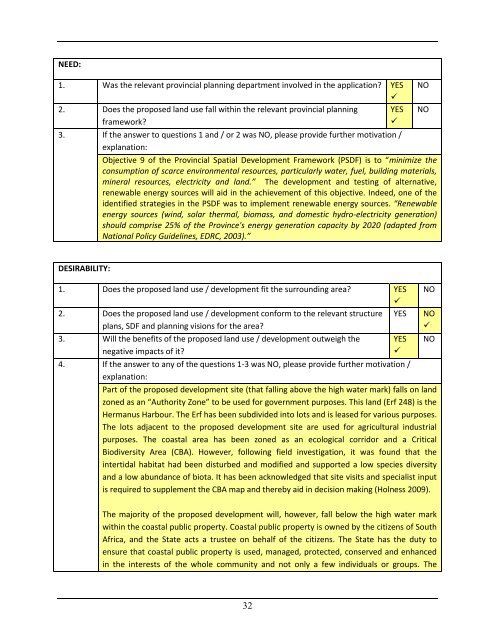
NEED:1. Was the relevant provincial planning department involved in the application? YES2. Does the proposed land use fall within the relevant provincial planning YESframework?3. If the answer to questions 1 and / or 2 was NO, please provide further motivation /explanation:Objective 9 of the Provincial Spatial Development Framework (PSDF) is to “minimize theconsumption of scarce environmental resources, particularly water, fuel, building materials,mineral resources, electricity and land.” The development and testing of alternative,renewable energy sources will aid in the achievement of this objective. Indeed, one of theidentified strategies in the PSDF was to implement renewable energy sources. “Renewableenergy sources (wind, solar thermal, biomass, and domestic hydro-electricity generation)should comprise 25% of the Province's energy generation capacity by 2020 (adapted fromNational Policy Guidelines, EDRC, 2003).”NONODESIRABILITY:1. Does the proposed land use / development fit the surrounding area? YES2. Does the proposed land use / development conform to the relevant structure YESplans, SDF and planning visions for the area?3. Will the benefits of the proposed land use / development outweigh thenegative impacts of it?4. If the answer to any of the questions 1-3 was NO, please provide further motivation /explanation:Part of the proposed development site (that falling above the high water mark) falls on landzoned as an “Authority Zone” to be used for government purposes. This land (Erf 248) is theHermanus Harbour. The Erf has been subdivided into lots and is leased for various purposes.The lots adjacent to the proposed development site are used for agricultural industrialpurposes. The coastal area has been zoned as an ecological corridor and a CriticalBiodiversity Area (CBA). However, following field investigation, it was found that theintertidal habitat had been disturbed and modified and supported a low species diversityand a low abundance of biota. It has been acknowledged that site visits and specialist inputis required to supplement the CBA map and thereby aid in decision making (Holness 2009).The majority of the proposed development will, however, fall below the high water markwithin the coastal public property. Coastal public property is owned by the citizens of SouthAfrica, and the State acts a trustee on behalf of the citizens. The State has the duty toensure that coastal public property is used, managed, protected, conserved and enhancedin the interests of the whole community and not only a few individuals or groups. TheYESNONONO32


