Vauxhall Nine Elms Battersea Opportunity Area Planning Framework
Vauxhall Nine Elms Battersea Opportunity Area Planning Framework
Vauxhall Nine Elms Battersea Opportunity Area Planning Framework

Create successful ePaper yourself
Turn your PDF publications into a flip-book with our unique Google optimized e-Paper software.
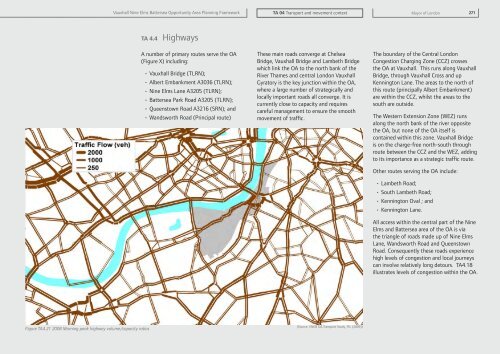
<strong>Vauxhall</strong> <strong>Nine</strong> <strong>Elms</strong> <strong>Battersea</strong> <strong>Opportunity</strong> <strong>Area</strong> <strong>Planning</strong> <strong>Framework</strong>TA 04 Transport and movement contextMayor of London 271TA 4.4 HighwaysA number of primary routes serve the OA(Figure X) including:• <strong>Vauxhall</strong> Bridge (TLRN);• Albert Embankment A3036 (TLRN);• <strong>Nine</strong> <strong>Elms</strong> Lane A3205 (TLRN);• <strong>Battersea</strong> Park Road A3205 (TLRN);• Queenstown Road A3216 (SRN); and• Wandsworth Road (Principal route)These main roads converge at ChelseaBridge, <strong>Vauxhall</strong> Bridge and Lambeth Bridgewhich link the OA to the north bank of theRiver Thames and central London <strong>Vauxhall</strong>Gyratory is the key junction within the OA,where a large number of strategically andlocally important roads all converge. It iscurrently close to capacity and requirescareful management to ensure the smoothmovement of traffic.The boundary of the Central LondonCongestion Charging Zone (CCZ) crossesthe OA at <strong>Vauxhall</strong>. This runs along <strong>Vauxhall</strong>Bridge, through <strong>Vauxhall</strong> Cross and upKennington Lane. The areas to the north ofthis route (principally Albert Embankment)are within the CCZ, whilst the areas to thesouth are outside.The Western Extension Zone (WEZ) runsalong the north bank of the river oppositethe OA, but none of the OA itself iscontained within this zone. <strong>Vauxhall</strong> Bridgeis on the charge-free north-south throughroute between the CCZ and the WEZ, addingto its importance as a strategic traffic route.Other routes serving the OA include:• Lambeth Road;• South Lambeth Road;• Kennington Oval ; and• Kennington Lane.All access within the central part of the <strong>Nine</strong><strong>Elms</strong> and <strong>Battersea</strong> area of the OA is viathe triangle of roads made up of <strong>Nine</strong> <strong>Elms</strong>Lane, Wandsworth Road and QueenstownRoad. Consequently these roads experiencehigh levels of congestion and local journeyscan involve relatively long detours. TA4.18illustrates levels of congestion within the OA.Figure TA4.21 2008 Morning peak highway volume/capacity ratios(Source: VNEB OA Transport Study, TfL (2009))