6 Bases during the Cold War
6 Bases during the Cold War
6 Bases during the Cold War
Create successful ePaper yourself
Turn your PDF publications into a flip-book with our unique Google optimized e-Paper software.
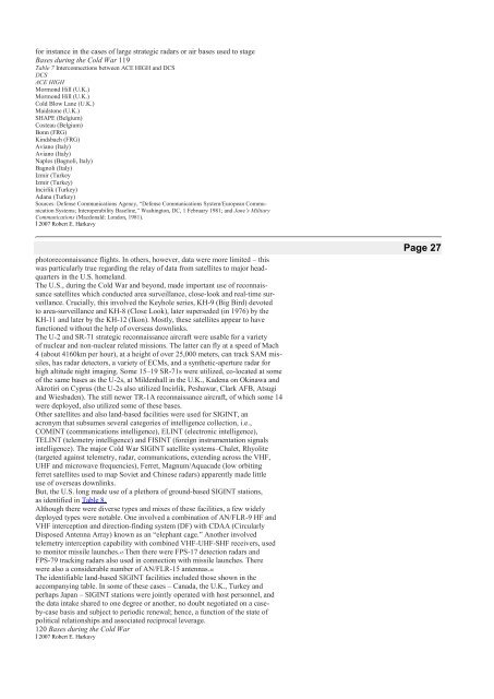
for instance in <strong>the</strong> cases of large strategic radars or air bases used to stage<strong>Bases</strong> <strong>during</strong> <strong>the</strong> <strong>Cold</strong> <strong>War</strong> 119Table 7 Interconnections between ACE HIGH and DCSDCSACE HIGHMormond Hill (U.K.)Mormond Hill (U.K.)<strong>Cold</strong> Blow Lane (U.K.)Maidstone (U.K.)SHAPE (Belgium)Costeau (Belgium)Bonn (FRG)Kindsbach (FRG)Aviano (Italy)Aviano (Italy)Naples (Bagnoli, Italy)Bagnoli (Italy)Izmir (TurkeyIzmir (Turkey)Incirlik (Turkey)Adana (Turkey)Sources: Defense Communications Agency, “Defense Communications System/European CommunicationSystems; Interoperability Baseline,” Washington, DC, 1 February 1981; and Jane’s MilitaryCommunications (Macdonald: London, 1981).İ 2007 Robert E. Harkavyphotoreconnaissance flights. In o<strong>the</strong>rs, however, data were more limited – thiswas particularly true regarding <strong>the</strong> relay of data from satellites to major headquartersin <strong>the</strong> U.S. homeland.The U.S., <strong>during</strong> <strong>the</strong> <strong>Cold</strong> <strong>War</strong> and beyond, made important use of reconnaissancesatellites which conducted area surveillance, close-look and real-time surveillance.Crucially, this involved <strong>the</strong> Keyhole series, KH-9 (Big Bird) devotedto area-surveillance and KH-8 (Close Look), later superseded (in 1976) by <strong>the</strong>KH-11 and later by <strong>the</strong> KH-12 (Ikon). Mostly, <strong>the</strong>se satellites appear to havefunctioned without <strong>the</strong> help of overseas downlinks.The U-2 and SR-71 strategic reconnaissance aircraft were usable for a varietyof nuclear and non-nuclear related missions. The latter can fly at a speed of Mach4 (about 4160km per hour), at a height of over 25,000 meters, can track SAM missiles,has radar detectors, a variety of ECMs, and a syn<strong>the</strong>tic-aperture radar forhigh altitude night imaging. Some 15–19 SR-71s were utilized, co-located at someof <strong>the</strong> same bases as <strong>the</strong> U-2s, at Mildenhall in <strong>the</strong> U.K., Kadena on Okinawa andAkrotiri on Cyprus (<strong>the</strong> U-2s also utilized Incirlik, Peshawar, Clark AFB, Atsugiand Wiesbaden). The still newer TR-1A reconnaissance aircraft, of which some 14were deployed, also utilized some of <strong>the</strong>se bases.O<strong>the</strong>r satellites and also land-based facilities were used for SIGINT, anacronym that subsumes several categories of intelligence collection, i.e.,COMINT (communications intelligence), ELINT (electronic intelligence),TELINT (telemetry intelligence) and FISINT (foreign instrumentation signalsintelligence). The major <strong>Cold</strong> <strong>War</strong> SIGINT satellite systems–Chalet, Rhyolite(targeted against telemetry, radar, communications, extending across <strong>the</strong> VHF,UHF and microwave frequencies), Ferret, Magnum/Aquacade (low orbitingferret satellites used to map Soviet and Chinese radars) apparently made littleuse of overseas downlinks.But, <strong>the</strong> U.S. long made use of a plethora of ground-based SIGINT stations,as identified in Table 8.Although <strong>the</strong>re were diverse types and mixes of <strong>the</strong>se facilities, a few widelydeployed types were notable. One involved a combination of AN/FLR-9 HF andVHF interception and direction-finding system (DF) with CDAA (CircularlyDisposed Antenna Array) known as an “elephant cage.” Ano<strong>the</strong>r involvedtelemetry interception capability with combined VHF-UHF-SHF receivers, usedto monitor missile launches.45 Then <strong>the</strong>re were FPS-17 detection radars andFPS-79 tracking radars also used in connection with missile launches. Therewere also a considerable number of AN/FLR-15 antennas.46The identifiable land-based SIGINT facilities included those shown in <strong>the</strong>accompanying table. In some of <strong>the</strong>se cases – Canada, <strong>the</strong> U.K., Turkey andperhaps Japan – SIGINT stations were jointly operated with host personnel, and<strong>the</strong> data intake shared to one degree or ano<strong>the</strong>r, no doubt negotiated on a caseby-casebasis and subject to periodic renewal; hence, a function of <strong>the</strong> state ofpolitical relationships and associated reciprocal leverage.120 <strong>Bases</strong> <strong>during</strong> <strong>the</strong> <strong>Cold</strong> <strong>War</strong>İ 2007 Robert E. HarkavyPage 27


