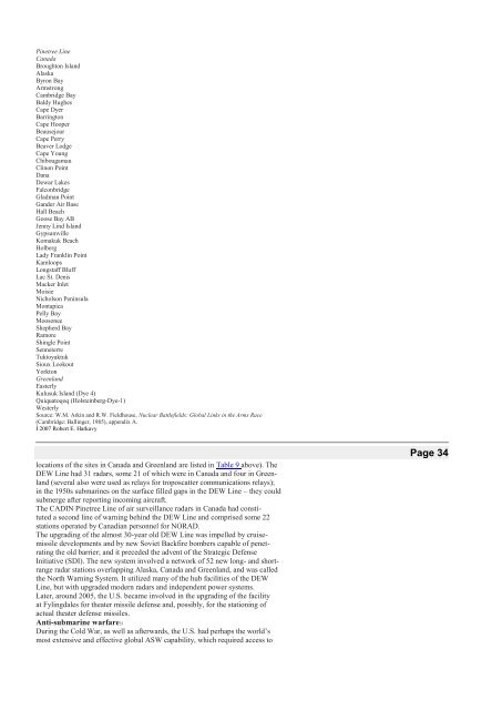
towards an arms-supply relationship with <strong>the</strong> USSR. Still earlier <strong>the</strong> U.S. apparentlyhad a similar SCF on Zanzibar Island, within Tanzania.Strategic early warning50One of <strong>the</strong> most obviously critical areas of intelligence involving foreign basesis strategic early warning, that is, warning of impending or unfolding nuclearattack. Here, as in so many areas of military endeavor, <strong>the</strong> U.S. was asymmetricallydependent on foreign access, and crucially so. Indeed, it was long <strong>the</strong> case,even before <strong>the</strong> advent of intercontinental missilery, that <strong>the</strong> U.S. relied onradars in Canada and Greenland for warning of approaching bombers at a timewhen such warning could provide several hours of response time. The asymmetrieswere partly because of <strong>the</strong> larger relative size of <strong>the</strong> USSR and partlybecause of <strong>the</strong> location of critical foreign terrain – Canada, Greenland, Iceland –between <strong>the</strong> U.S. and <strong>the</strong> trans-Arctic routes that would be traversed by missilesand bombers across <strong>the</strong> arctic regions between <strong>the</strong> superpowers.Several key U.S. early-warning systems utilized foreign access; ground stationsused to relay data from early-warning satellites; <strong>the</strong> BMEWS radar systemdirected against Soviet ICBMs, <strong>the</strong> several layers of radar pickets used to detectbombers en route to <strong>the</strong> U.S. from <strong>the</strong> Arctic region; and a variety of o<strong>the</strong>rsensors which might be used in collateral or supplementary roles.Regarding early-warning satellites, <strong>the</strong> U.S. relied primarily on what havebecome known as DSP East and DSP West (earlier <strong>the</strong>se were called MIDASsatellites). The former had <strong>the</strong> primary task of watching for ICBM launches, <strong>the</strong>latter for SLBM launches in <strong>the</strong> Atlantic.The Code 647 Defense Support Program satellite – DSP East – sat some23,000 miles above <strong>the</strong> Indian Ocean in geosynchronous orbit, monitoring <strong>the</strong>eastern hemisphere. It contained an infrared telescope equipped with thousandsof tiny lead-sulphide detectors designed to pick up <strong>the</strong> hot exhaust flame producedby large rocket engines <strong>during</strong> <strong>the</strong> boost phase of <strong>the</strong>ir flights. It had fullcoverage of Soviet missile fields from an orbit more or less above <strong>the</strong> equatorand, in <strong>the</strong> case of mass launchings, could tell what kinds of missiles had beenlaunched and from where. Hence, DSP East could also provide valuableinformation about what kind of attack had been launched, that is, <strong>the</strong> likely targetingmix. That would in turn have guided <strong>the</strong> targeting of a U.S. counterforceresponse.The principal and necessary link between DSP East and NORAD was <strong>the</strong>down-link facility at Nurrungar, Australia (<strong>the</strong>re were also control and trackingfunctions at Pine Gap and on Guam) described as a highly vulnerable set ofantennas, transmitters and computational facilities. This “readout station” in turnwould relay data to NORAD, variously by underseas cable, by HF radio links orvia <strong>the</strong> Defense Satellite Communications System, and in turn via a switchingstation in Hawaii. These various alternative communications links between Nurrungarand Buckley AFB in Colorado involved foreign access to New Zealand,Fiji, Norfolk Island and Canada’s British Columbia at Port Alberni. In recent<strong>Bases</strong> <strong>during</strong> <strong>the</strong> <strong>Cold</strong> <strong>War</strong> 125İ 2007 Robert E. Harkavyyears, however, ano<strong>the</strong>r down-link for DSP East (called <strong>the</strong> Simplified ProcessingStation) had been made operational at Kapaun, FDR Germany.A second major U.S. strategic warning system used to monitor ICBMlaunches was BMEWS, which comprised three major radars (located at Clear,Alaska, Thule, Greenland and Fylingdales Moor, U.K.). These radars becameoperational in 1950 and had 4800-km ranges. The BMEWS facility includedfour AN FPS-50 detection radars and an AN/FPS-49 tracking radar – <strong>the</strong>se alsoacted as contributing sensors for <strong>the</strong> SPADATS system. Altoge<strong>the</strong>r, <strong>the</strong>re were12 radars with ranges of 4800 km.Finally, <strong>the</strong> U.S. had long relied – primarily for warning of <strong>the</strong> approach ofbombers – on <strong>the</strong> series of radar picket lines across <strong>the</strong> Arctic known as <strong>the</strong>Distant Early <strong>War</strong>ning (DEW) and Continental Air Defense Integration North(CADIN) Pinetree lines. These had been located across Alaska, Canada andGreenland, with a few additional outposts in Iceland and <strong>the</strong> Faeroe Islands (<strong>the</strong>126 <strong>Bases</strong> <strong>during</strong> <strong>the</strong> <strong>Cold</strong> <strong>War</strong>Table 9 Location of DEW Line and CADIN Pinetree Line radar sites in Canada andGreenland, 1985DEW LinesPage 32Page 33
Pinetree LineCanadaBroughton IslandAlaskaByron BayArmstrongCambridge BayBaldy HughesCape DyerBarringtonCape HooperBeausejourCape PerryBeaver LodgeCape YoungChibougamauClinon PointDanaDewar LakesFalconbridgeGladman PointGander Air BaseHall BeachGoose Bay ABJenny Lind IslandGypsumvilleKomakuk BeachHolbergLady Franklin PointKamloopsLongstaff BluffLac St. DenisMacker InletMoisieNicholson PeninsulaMontapicaPelly BayMoosoneeShepherd BayRamoreShingle PointSenneterreTuktoyaktukSioux LookoutYorktonGreenlandEasterlyKulusuk Island (Dye 4)Quiquatoqoq (Holsteinberg-Dye-1)WesterlySource: W.M. Arkin and R.W. Fieldhouse, Nuclear Battlefields: Global Links in <strong>the</strong> Arms Race(Cambridge: Ballinger, 1985), appendix A.İ 2007 Robert E. Harkavylocations of <strong>the</strong> sites in Canada and Greenland are listed in Table 9 above). TheDEW Line had 31 radars, some 21 of which were in Canada and four in Greenland(several also were used as relays for troposcatter communications relays);in <strong>the</strong> 1950s submarines on <strong>the</strong> surface filled gaps in <strong>the</strong> DEW Line – <strong>the</strong>y couldsubmerge after reporting incoming aircraft.The CADIN Pinetree Line of air surveillance radars in Canada had constituteda second line of warning behind <strong>the</strong> DEW Line and comprised some 22stations operated by Canadian personnel for NORAD.The upgrading of <strong>the</strong> almost 30-year old DEW Line was impelled by cruisemissiledevelopments and by new Soviet Backfire bombers capable of penetrating<strong>the</strong> old barrier; and it preceded <strong>the</strong> advent of <strong>the</strong> Strategic DefenseInitiative (SDI). The new system involved a network of 52 new long- and shortrangeradar stations overlapping Alaska, Canada and Greenland, and was called<strong>the</strong> North <strong>War</strong>ning System. It utilized many of <strong>the</strong> hub facilities of <strong>the</strong> DEWLine, but with upgraded modern radars and independent power systems.Later, around 2005, <strong>the</strong> U.S. became involved in <strong>the</strong> upgrading of <strong>the</strong> facilityat Fylingdales for <strong>the</strong>ater missile defense and, possibly, for <strong>the</strong> stationing ofactual <strong>the</strong>ater defense missiles.Anti-submarine warfare51During <strong>the</strong> <strong>Cold</strong> <strong>War</strong>, as well as afterwards, <strong>the</strong> U.S. had perhaps <strong>the</strong> world’smost extensive and effective global ASW capability, which required access toPage 34
- Page 2 and 3: This provided the U.S. access to a
- Page 4 and 5: ecame a hot issue within Japan, and
- Page 6 and 7: SpainRotaMajor naval base; also air
- Page 8 and 9: eturn to the link here with aircraf
- Page 10 and 11: which were in Fairbanks (Alaska), T
- Page 13: Molesworth), Belgium (Florennes), t
- Page 17 and 18: III,” 14 stations giving flexible
- Page 19 and 20: wire retaliation strike plan. The n
- Page 21 and 22: Ocean surface surveillance47The U.S
- Page 23: each site, providing variable cover
- Page 27 and 28: that is, the Limited Test Ban Treat
- Page 29 and 30: Missile Crisis.68At another level,
- Page 31 and 32: Access for Soviet surface ships.Per
- Page 33 and 34: nel in Libya, whose air force compr
- Page 35 and 36: systems (an exception, of course wa
- Page 37 and 38: Madagascar). There was also a signi
- Page 39 and 40: Aden, Bahrain, Malta, Mauritius, Si