Drainage Design Manual - the City of San Luis Obispo
Drainage Design Manual - the City of San Luis Obispo
Drainage Design Manual - the City of San Luis Obispo

You also want an ePaper? Increase the reach of your titles
YUMPU automatically turns print PDFs into web optimized ePapers that Google loves.
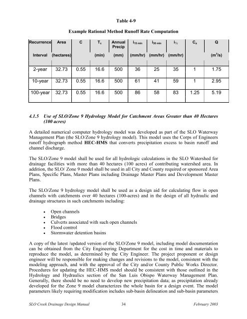
Table 4-9Example Rational Method Run<strong>of</strong>f Rate ComputationRecurrence Area C T c AnnualPrecipi 15 min i 30 min i Tc C a QInterval (hectares) (min) (mm) (mm/hr) (mm/hr) (mm/hr) (m 3 /s)2-year 32.73 0.55 16.6 500 36 25 35 1 1.7510-year 32.73 0.55 16.6 500 61 41 59 1 2.95100-year 32.73 0.55 16.6 500 86 58 83 1.25 5.194.1.5 Use <strong>of</strong> SLO/Zone 9 Hydrology Model for Catchment Areas Greater than 40 Hectares(100 acres)A detailed numerical computer hydrology model was developed as part <strong>of</strong> <strong>the</strong> SLO WaterwayManagement Plan (<strong>the</strong> SLO/Zone 9 hydrology model). This model uses <strong>the</strong> Corps <strong>of</strong> Engineersrun<strong>of</strong>f hydrograph method HEC-HMS that converts precipitation excess to basin run<strong>of</strong>f andchannel discharge.The SLO/Zone 9 model shall be used for all hydrologic calculations in <strong>the</strong> SLO Watershed fordrainage facilities with more than 40 hectares (100 acres) <strong>of</strong> contributing watershed area. Inaddition, <strong>the</strong> SLO/ Zone 9 model shall be used in all <strong>City</strong> and County required or sponsored AreaPlans, Specific Plans, Master Plans including <strong>Drainage</strong> Master Plans and Development MasterPlans.The SLO/Zone 9 hydrology model shall be used as a design aid for calculating flow in openchannels with catchments over 40 hectares (100-acres) and in <strong>the</strong> design <strong>of</strong> all hydraulic anddrainage structures in such catchments including:Open channelsBridgesCulverts associated with such open channelsFlood controlStormwater detention basinsA copy <strong>of</strong> <strong>the</strong> latest /updated version <strong>of</strong> <strong>the</strong> SLO/Zone 9 model, including model documentationcan be obtained from <strong>the</strong> <strong>City</strong> Engineering Department for <strong>the</strong> cost in time and materials toreproduce <strong>the</strong> model, as determined by <strong>the</strong> <strong>City</strong> Engineer. The project proponent or designengineer will be responsible for making changes and revisions to <strong>the</strong> model, consistent with <strong>the</strong>modeling approach, and with <strong>the</strong> approval <strong>of</strong> <strong>the</strong> <strong>City</strong> and/or County Public Works Director.Procedures for updating <strong>the</strong> HEC-HMS model should be consistent with those outlined in <strong>the</strong>Hydrology and Hydraulics section <strong>of</strong> <strong>the</strong> <strong>San</strong> <strong>Luis</strong> <strong>Obispo</strong> Waterway Management Plan.Generally, <strong>the</strong>re should be no need to develop new precipitation data; as precipitation alreadydeveloped for <strong>the</strong> Zone 9 model characterizes <strong>the</strong> whole basin for a design event. The modelparameters likely requiring modification includes sub-basin delineation and sub-basin parametersSLO Creek <strong>Drainage</strong> <strong>Design</strong> <strong>Manual</strong> 34 February 2003