

Strategic Flood Risk Assessment - Wiltshire Council
Strategic Flood Risk Assessment - Wiltshire Council
Strategic Flood Risk Assessment - Wiltshire Council

Create successful ePaper yourself
Turn your PDF publications into a flip-book with our unique Google optimized e-Paper software.
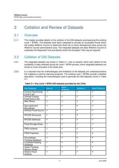
<strong>Wiltshire</strong> <strong>Council</strong>SFRA High Level Executive Summary3 Collation and Review of Datasets3.1 Overview3.1.1 This chapter provides details on the collation of the GIS datasets accompanying the existingLevel 1 SFRAs. The datasets have been integrated to provide an accessible format whichwill enable <strong>Wiltshire</strong> <strong>Council</strong> to determine flood risk to future development sites across the<strong>Wiltshire</strong> <strong>Council</strong> administrative area. The integrated datasets will allow <strong>Wiltshire</strong> <strong>Council</strong> toundertake the Sequential Test and identify where the Exception Test may be required.3.2 Collation of GIS Datasets3.2.1 The integrated datasets are shown in Table 3-1. Due to variation within each district of theavailability of data collected during the Level 1 SFRA process, some integrated datasets areshown to cover only parts of the study area.3.2.2 It is important that the methodologies and limitations of the datasets are understood beforethe mapping is used for planning purposes. The existing Level 1 SFRAs provide a detaileddescription, including the methodologies used to generate the GIS datasets shown in Table3-1.Table 3-1: Key Level 1 SFRA GIS datasets provided by the LPAsKey Datasets KennetNorth<strong>Wiltshire</strong>Salisbury West <strong>Wiltshire</strong>Current <strong>Flood</strong> Zones 2 and 3 a/bClimate Change <strong>Flood</strong> Zone 3 a/bMain Rivers Sub-catchment BoundariesArtificial <strong>Flood</strong> Source NFCDD Structures NFCDD Defences <strong>Flood</strong> Storage Areas FRIS Incidents FRIS Properties Groundwater<strong>Flood</strong>ing DatabaseLocalised <strong>Flood</strong>ingDatabaseSewer <strong>Flood</strong>ingWessex WaterHistoric <strong>Flood</strong>Outlines 11 June 2009


