

Strategic Flood Risk Assessment - Wiltshire Council
Strategic Flood Risk Assessment - Wiltshire Council
Strategic Flood Risk Assessment - Wiltshire Council

You also want an ePaper? Increase the reach of your titles
YUMPU automatically turns print PDFs into web optimized ePapers that Google loves.
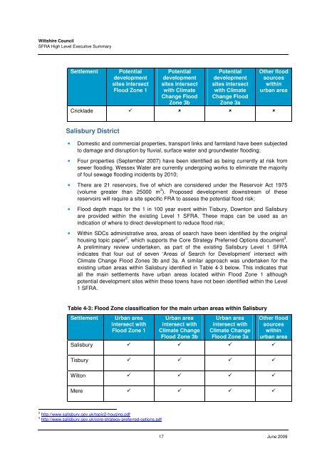
<strong>Wiltshire</strong> <strong>Council</strong>SFRA High Level Executive SummarySettlementPotentialdevelopmentsites intersect<strong>Flood</strong> Zone 1Potentialdevelopmentsites intersectwith ClimateChange <strong>Flood</strong>Zone 3bPotentialdevelopmentsites intersectwith ClimateChange <strong>Flood</strong>Zone 3aOther floodsourceswithinurban areaCricklade Salisbury District• Domestic and commercial properties, transport links and farmland have been subjectedto damage and disruption by fluvial, surface water and groundwater flooding;• Four properties (September 2007) have been identified as being currently at risk fromsewer flooding. Wessex Water are currently undergoing works to eliminate the majorityof foul sewage flooding incidents by 2010;• There are 21 reservoirs, five of which are considered under the Reservoir Act 1975(volume greater than 25000 m 3 ). Proposed development downstream of thesereservoirs will require a site specific FRA to assess the potential flood risk;• <strong>Flood</strong> depth maps for the 1 in 100 year event within Tisbury, Downton and Salisburyare provided within the existing Level 1 SFRA. These maps can be used as anindication of where to direct development to reduce flood risk;• Within SDCs administrative area, areas of search have been identified by the originalhousing topic paper 2 , which supports the Core Strategy Preferred Options document 3 .A preliminary review undertaken, as part of the existing Salisbury Level 1 SFRAindicates that four out of seven ‘Areas of Search for Development’ intersect withClimate Change <strong>Flood</strong> Zones 3b and 3a. A similar approach was undertaken for theexisting urban areas within Salisbury identified in Table 4-3 below. This indicates thatall the main settlements have urban areas located within <strong>Flood</strong> Zone 1 althoughpotential development sites within these towns have not been identified within the Level1 SFRA.Table 4-3: <strong>Flood</strong> Zone classification for the main urban areas within SalisburySettlementUrban areaintersect with<strong>Flood</strong> Zone 1Urban areaintersect withClimate Change<strong>Flood</strong> Zone 3bUrban areaintersect withClimate Change<strong>Flood</strong> Zone 3aOther floodsourceswithinurban areaSalisbury Tisbury Wilton Mere 2 http://www.salisbury.gov.uk/topic2-housing.pdf3 http://www.salisbury.gov.uk/core-strategy-preferred-options.pdf17 June 2009


