

Strategic Flood Risk Assessment - Wiltshire Council
Strategic Flood Risk Assessment - Wiltshire Council
Strategic Flood Risk Assessment - Wiltshire Council

You also want an ePaper? Increase the reach of your titles
YUMPU automatically turns print PDFs into web optimized ePapers that Google loves.
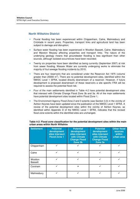
<strong>Wiltshire</strong> <strong>Council</strong>SFRA High Level Executive SummaryNorth <strong>Wiltshire</strong> District• Fluvial flooding has been experienced within Chippenham, Calne, Malmesbury andCricklade in recent years. Properties, transport links and agricultural land has beensubject to damage and disruption;• Surface water flooding has been experienced in Wootton Bassett, Calne, Malmesburyand Marston Meysey affecting properties and transport links. The nature of theunderlying geology means that groundwater flooding is less significant than othersources, although isolated occurrences have been recorded;• Twenty six properties have been identified as being currently (September 2007) at riskfrom sewer flooding. Wessex Water are currently undergoing works to eliminate themajority of foul sewage flooding incidents by 2010;• There are four reservoirs that are considered under the Reservoir Act 1975 (volumegreater than 25000 m 3 ). There are no potential development sites, identified within theNWDC Level 1 SFRA, located directly downstream of a reservoir. However, if futuredevelopment is proposed downstream of these reservoirs a site specific FRA will berequired to assess the potential flood risk;• Four of the main settlements identified in Table 4-2 have potential development sitesthat intersect with Climate Change <strong>Flood</strong> Zone 3b and 3a. All of the main settlementshave potential development sites located within <strong>Flood</strong> Zone 1;• The Environment Agency <strong>Flood</strong> Zone 2 and 3 extents (see Section 3.3) in the vicinity ofAshton Keynes have been updated since the publication of the NWDC Level 1 SFRA. Areview of the potential development sites within the vicinity of Ashton Keynes, asidentified within Appendix D of the NWDC Level 1 SFRA, indicates that the revisedflood zone extents within the identified sites are unchanged.Table 4-2: <strong>Flood</strong> zone classification for the potential development sites within the mainurban areas within North <strong>Wiltshire</strong>SettlementPotentialdevelopmentsites intersect<strong>Flood</strong> Zone 1Potentialdevelopmentsites intersectwith ClimateChange <strong>Flood</strong>Zone 3bPotentialdevelopmentsites intersectwith ClimateChange <strong>Flood</strong>Zone 3aOther floodsourceswithinurban areaChippenham Calne WoottonBassett Corsham Malmesbury 16 June 2009


