

Strategic Flood Risk Assessment - Wiltshire Council
Strategic Flood Risk Assessment - Wiltshire Council
Strategic Flood Risk Assessment - Wiltshire Council

You also want an ePaper? Increase the reach of your titles
YUMPU automatically turns print PDFs into web optimized ePapers that Google loves.
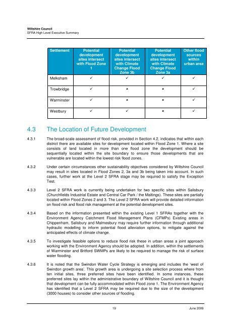
<strong>Wiltshire</strong> <strong>Council</strong>SFRA High Level Executive SummarySettlementPotentialdevelopmentsites intersectwith <strong>Flood</strong> Zone1Potentialdevelopmentsites intersectwith ClimateChange <strong>Flood</strong>Zone 3bPotentialdevelopmentsites intersectwith ClimateChange <strong>Flood</strong>Zone 3aOther floodsourceswithinurban areaMelksham Trowbridge Warminster Westbury 4.3 The Location of Future Development4.3.1 The broad-scale assessment of flood risk, provided in Section 4.2, indicates that within eachdistrict there are available sites for development located within <strong>Flood</strong> Zone 1. Where a siteconsists of land located in more than one flood zone the development should besequentially located within the site boundary to ensure those developments that arevulnerable are located within the lowest risk flood zones.4.3.2 Under certain circumstances other sustainability objectives considered by <strong>Wiltshire</strong> <strong>Council</strong>may result in sites located in <strong>Flood</strong> Zones 2, 3a and 3b being taken into account. In suchcases, further work at the Level 2 SFRA stage may be required to satisfy the ExceptionTest.4.3.3 Level 2 SFRA work is currently being undertaken for two specific sites within Salisbury(Churchfields Industrial Estate and Central Car Park / the Maltings). These sites are partiallylocated within <strong>Flood</strong> Zones 2 and 3. The Level 2 SFRA work will provide detailed informationon flood risk and flood risk management at the potential development sites.4.3.4 Based on the information presented within the existing Level 1 SFRAs together with theEnvironment Agency Catchment <strong>Flood</strong> Management Plans (CFMPs) Existing areas inChippenham, Salisbury and Malmesbury may require further information through additionalhydraulic modelling to inform potential flood alleviation options, to mitigate against theanticipated effects of climate change.4.3.5 To investigate feasible options to reduce flood risk these in urban areas a joint approachworking with the Environment Agency should be adopted. In addition, within the settlementsof Warminster and Britford SWMPs are likely to be required to manage the risk of surfacewater flooding.4.3.6 It is noted that the Swindon Water Cycle Strategy is emerging and includes the ‘west ofSwindon growth area’. This growth area is undergoing a site selection process where fromten initial sites, three preferred sites have been identified. In some instances, thesepreferred sites lay within the administrative boundary of <strong>Wiltshire</strong> <strong>Council</strong> and it is thoughtthat development can be fully accommodated within <strong>Flood</strong> zone 1. The Environment Agencyhas identified that a Level 2 SFRA may be required due to the size of the development(3000 houses) to consider other sources of flooding.19 June 2009


