

Strategic Flood Risk Assessment - Wiltshire Council
Strategic Flood Risk Assessment - Wiltshire Council
Strategic Flood Risk Assessment - Wiltshire Council

You also want an ePaper? Increase the reach of your titles
YUMPU automatically turns print PDFs into web optimized ePapers that Google loves.
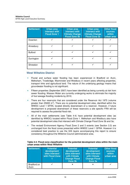
<strong>Wiltshire</strong> <strong>Council</strong>SFRA High Level Executive SummarySettlementUrban areaintersect with<strong>Flood</strong> Zone 1Urban areaintersect withClimate Change<strong>Flood</strong> Zone 3bUrban areaintersect withClimate Change<strong>Flood</strong> Zone 3aOther floodsourceswithinurban areaDownton Amesbury Bulford Durrington Shrewton West <strong>Wiltshire</strong> District• Fluvial and surface water flooding has been experienced in Bradford on Avon,Melksham, Trowbridge, Warminster and Westbury in recent years affecting properties,transport links and agricultural land. The nature of the underlying geology means thatgroundwater flooding is not significant;• Fifteen properties (September 2007) have been identified as being currently at risk fromsewer flooding. Wessex Water are currently undergoing works to eliminate the majorityof foul sewage flooding incidents by 2010;• There are four reservoirs that are considered under the Reservoir Act 1975 (volumegreater than 25000 m 3 ). There are no potential development sites, identified within theWWDC Level 1 SFRA, located directly downstream of a reservoir. However, if futuredevelopment is proposed downstream of these reservoirs a site specific FRA will berequired to assess the potential flood risk;• All of the main settlements (see Table 4-4) have potential development sites (asidentified by WWDC) located within <strong>Flood</strong> Zone 1. Melksham and Westbury also havepotential development sites that intersect with Climate Change <strong>Flood</strong> Zone 3b and 3a;• The revised Environment Agency <strong>Flood</strong> Zone 2 and 3 extents (see Section 3.3) areunchanged from the flood zones presented within WWDC Level 1 SFRA. However it isconsidered best practice to use the GIS layers accompanying this report to ensureconsistency throughout the <strong>Wiltshire</strong> <strong>Council</strong> administrative area.Table 4-4: <strong>Flood</strong> zone classification for the potential development sites within the mainurban areas within West <strong>Wiltshire</strong>SettlementBradford onAvonPotentialdevelopmentsites intersectwith <strong>Flood</strong> Zone1Potentialdevelopmentsites intersectwith ClimateChange <strong>Flood</strong>Zone 3bPotentialdevelopmentsites intersectwith ClimateChange <strong>Flood</strong>Zone 3aOther floodsourceswithinurban area 18 June 2009


