

Strategic Flood Risk Assessment - Wiltshire Council
Strategic Flood Risk Assessment - Wiltshire Council
Strategic Flood Risk Assessment - Wiltshire Council

You also want an ePaper? Increase the reach of your titles
YUMPU automatically turns print PDFs into web optimized ePapers that Google loves.
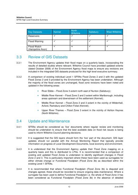
<strong>Wiltshire</strong> <strong>Council</strong>SFRA High Level Executive SummaryKey Datasets KennetNorth<strong>Wiltshire</strong>Salisbury West <strong>Wiltshire</strong>Reservoirs <strong>Flood</strong> Warning <strong>Flood</strong> Watch(Hampshire Avon) 3.3 Review of GIS Datasets3.3.1 The Environment Agency updates their flood maps on a quarterly basis, incorporating theresults of detailed studies where relevant. <strong>Wiltshire</strong> <strong>Council</strong> have provided updated extents(dated October 2008) of the Environment Agency flood maps to ensure any revisions areincluded in the integrated GIS datasets produced for this high level executive summary.3.3.2 A comparison of existing individual Level 1 SFRAs <strong>Flood</strong> Zones 2 and 3 with the updated<strong>Flood</strong> Zones 2 and 3 provided by the Environment Agency has been undertaken. Althoughthe majority of the flood zones are unchanged, flood zone revisions have been noted andupdated in the following areas:• River Ebble – <strong>Flood</strong> Zone 3 extent north east of Nunton (Salisbury);• Middle River Kennet – <strong>Flood</strong> Zone 2 and 3 extent within Marlborough, includingareas upstream and downstream of the settlement (Kennet);• Middle River Kennet – <strong>Flood</strong> Zone 2 and 3 extent in the vicinity of Mildenhall,Axford, Ramsbury and Chilton Foliat (Kennet);• Upper River Thames – <strong>Flood</strong> Zone 3 extent in the vicinity of Ashton Keynes(North <strong>Wiltshire</strong>).3.4 Update and Maintenance3.4.1 SFRAs should be considered as ‘live’ documents where regular review and monitoringshould be undertaken to ensure that the best available data on flood risk issues is beingused to inform <strong>Wiltshire</strong> <strong>Council</strong> planning decisions.3.4.2 It is suggested that the GIS layers should form the ‘live’ part of the document. GIS layerupdates should run parallel with the Annual Monitoring Report that typically provideinformation on progress of Local Development Documents, local economy and environment.3.4.3 It is understood that the Environment Agency update their <strong>Flood</strong> Zone mapping on aquarterly basis and this is distributed to LPAs. It is recommended that a comparison ofexisting and updated <strong>Flood</strong> Zones is undertaken to identify significant changes in <strong>Flood</strong>Zone 2 and 3. This is particularly important where these have been used as surrogates foreither climate change or Functional <strong>Flood</strong>plain (<strong>Flood</strong> Zone 3b) as described within theexisting Level 1 SFRAs.3.4.4 It is recommended that where Functional <strong>Flood</strong>plain (<strong>Flood</strong> Zone 3b) is disputed andchanges agreed, these should be recorded to ensure ongoing data maintenance. Where asurrogate has been used to define Functional <strong>Flood</strong>plain i.e. the whole of <strong>Flood</strong> Zone 3 hasbeen considered as Functional <strong>Flood</strong>plain (<strong>Flood</strong> Zone 3b) in the absence of detailed12 June 2009


