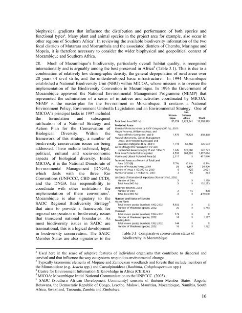
iophysical gradients that influence the distribution and performance of both species andfunctional types 2 . Many plant and animal species in the project area for example, also occur inother regions of Southern Africa 3 . In reviewing the available biodiversity information of the twofocal districts of Mutarara and Morrumbala and the associated districts of Chemba, Maringue andMopeia, it is therefore necessary to consider the wider biophysical and geopolitical context ofMozambique and Southern Africa.28. Much of Mozambique’s biodiversity, particularly overall habitat quality, is recognisedinternationally and is arguably among the best preserved in Africa 4 (Table 3.1). This is due to acombination of relatively low demographic density, the general depopulation of rural areas over20 years of civil strife, and the underdeveloped basic infrastructure. In 1994 Mozambiqueestablished a National Biodiversity Unit (NBU) within MICOA, whose mission is to oversee theimplementation of the Biodiversity Convention in Mozambique. In 1996 the Government ofMozambique approved the National Environmental Management Programme (NEMP) thatrepresented the culmination of a series of initiatives and activities coordinated by MICOA.NEMP is the master-plan for the Environment in Mozambique. It contains a NationalEnvironment Policy, Environment Umbrella Legislation and an Environmental Strategy. One ofMICOA’s principal tasks in 1997 includedthe formulation and subsequentratification of a National Strategy andAction Plan for the Conservation ofBiological Diversity. Within theframework of this strategy, a number ofbiodiversity conservation issues are beingaddressed. These include technical, legal,political, cultural and socio-economicaspects of biological diversity. InsideMICOA, it is the National Directorate ofEnvironmental Management (DNGA),which deals with the three RioConventions (UNFCCC, CBD and CCD),and the DNGA has responsibility tocoordinate with other institutions theimplementation of these conventions 5 .Mozambique is also signatory to theSADC Regional Biodiversity Strategy 6that aims to provide a framework forregional cooperation in biodiversity issuesthat transcend national boundaries. Asmost biodiversity issues in SADC aretransnational, this is a logical developmentin biodiversity conservation. The SADCMember States are also signatories to theTable 3.1 Comparative conservation status ofbiodiversity in Mozambique2 Used here in the sense of adaptive features of individual organisms that contribute to dispersal andsurvival and that influence the way ecosystems respond to environmental change.3 Typically taxonomic elements of Mopane and Zambezian woodlands and forests that include members ofthe Mimosoideae (e.g. Acacia spp.) and Caesalpinoideae (Bauhinia, Colophospermum spp.)4 Centre for Environment Information & Knowledge in Africa (CEIKA)5 MICOA: Mozambique Initial National Communication to the UNFCCC. (2003).6 SADC (Southern African Development Community) consists of thirteen Member States: Angola,Botswana, the Democratic Republic of Congo, Lesotho, Malawi, Mauritius, Mozambique, Namibia, SouthAfrica, Swaziland, Tanzania, Zambia and Zimbabwe.16
CBD.29 The country of Mozambique (801,590 km 2 ) contains a wide diversity of terrestrial,freshwater and marine habitats. However, the biodiversity of Mozambique is poorly known andpoorly documented due to a number of factors including lack of human resources, lack ofopportunities to carry out field-studies during the period of civil unrest and weak institutionalcapacity. A limited amount of data is available for some taxonomic groups, but some pre-wardata especially those dealing with land cover are outdated. Existing knowledge is dispersed overvarious sectoral agencies as well as with individuals in the form of project documents, reports,scientific articles, maps, aerial photographs and satellite imagery. The information has not beenintegrated at the national, local and even in some cases the institutional level. In addition, datasets are based on different classification systems, organized along different formats and are ofvarying accuracy.30. A number of biodiversity mapping and inventory activities have been undertaken, or areunderway. But, as may be expected, in the absence of baseline data, there is little accurateinformation (with a few notable exceptions in National Parks and Game Reserves) regardingtrends in biodiversity and processes or activities threatening biodiversity.31. The five districts are located along the lower Zambezi valley that serves as a biodiversitycorridor from the uplands in Tete Province to the expansive 12,000km 2 Zambezi delta in SofalaProvince. While little is known of biodiversity within the five districts, considerable national andinternational interest focuses on the delta – one of the largest wetland systems in southern Africa.The Zambezi river basin, the largest basin entirely within the SADC region is rich in wetlands.The basin drains a total area of almost 1.4 million km 2 , and wetlands cover almost 66,000 km 2with a total water storage 7 estimated at 100,000 million m 3 . In 2003, the GOM declared theMarromeu Complex of the Zambezi Delta to be the first Wetland of International Importance inMozambique under the Ramsar Convention. The Ramsar Convention is the world’s foremostinternational agreement for the protection and wise use of wetlands, and requires nationalcommitment to the sustainable management of designated wetland sites. The complex is host tomany large mammals and birds 8 . While most conservation management tends to focus on fauna,much less activity is directed to documenting the flora - an exception being the relatively speciesrichGorongosa Reserve further.32. Water resources development projects have substantially altered the hydrological regime ofthe Zambezi Delta and impacted biodiversity 9 . Prior to the construction of Kariba Dam on themiddle Zambezi River, peak floods spread over a mosaic of vegetation communities. Floodplaingrasslands were inundated with floodwaters for up to nine months of the year, with many areasbeing saturated throughout the dry season. With the closure of Kariba Dam in 1959 and CahoraBassa Dam in 1974, nearly 90% of the Zambezi catchment has become regulated so that thenatural flood cycles of the lower Zambezi River cannot be maintained. Flooding events in thedelta, when they occur, now depend on local rainfall-runoff or unplanned (possibly catastrophic)water releases from the upstream dams. These hydrological changes are further exacerbated bythe construction of dikes along the lower Zambezi that prevent medium sized floods up to 13,000m 3/s from inundating the south bank floodplains. The implications for biodiversity in the face ofthese hydrological changes in the delta are profound and must be considered in the context of thehydrogeomorphic processes that control vegetation distribution and abundance. Woody savannaand thicket species have increased in density and colonized far into the floodplain grasslandmosaic. Relatively drought-tolerant grassland species have displaced flood-tolerant species in the7 http://www.sardc.net/imercsa/zambezi/Cep/fsheet16/index.htm8 The International Crane Foundationhttp://www.savingcranes.org/conservation/our_projects/program.cfm?id=239 Timberlake, J. (1998).17