LOWER ZAMBEZI RIVER BASIN BASELINE DATA ON LANDUSE ...
LOWER ZAMBEZI RIVER BASIN BASELINE DATA ON LANDUSE ...
LOWER ZAMBEZI RIVER BASIN BASELINE DATA ON LANDUSE ...

Create successful ePaper yourself
Turn your PDF publications into a flip-book with our unique Google optimized e-Paper software.
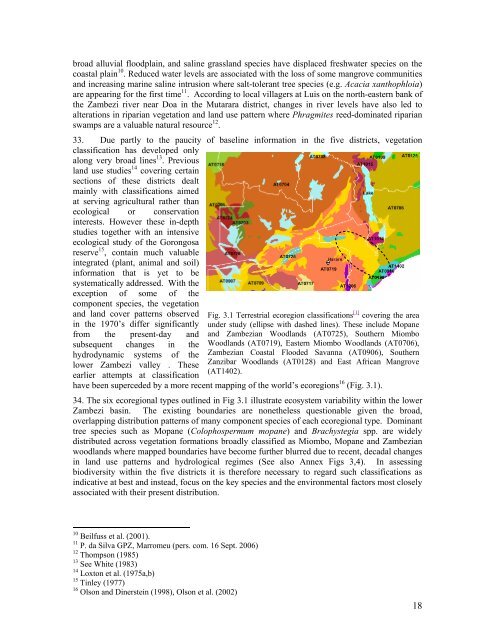
oad alluvial floodplain, and saline grassland species have displaced freshwater species on thecoastal plain 10 . Reduced water levels are associated with the loss of some mangrove communitiesand increasing marine saline intrusion where salt-tolerant tree species (e.g. Acacia xanthophloia)are appearing for the first time 11 . According to local villagers at Luis on the north-eastern bank ofthe Zambezi river near Doa in the Mutarara district, changes in river levels have also led toalterations in riparian vegetation and land use pattern where Phragmites reed-dominated riparianswamps are a valuable natural resource 12 .33. Due partly to the paucity of baseline information in the five districts, vegetationclassification has developed onlyalong very broad lines 13 . Previousland use studies 14 covering certainsections of these districts dealtmainly with classifications aimedat serving agricultural rather thanecological or conservationinterests. However these in-depthstudies together with an intensiveecological study of the Gorongosareserve 15 , contain much valuableintegrated (plant, animal and soil)information that is yet to besystematically addressed. With theexception of some of thecomponent species, the vegetationand land cover patterns observed Fig. 3.1 Terrestrial ecoregion classifications [1] covering the areain the 1970’s differ significantly under study (ellipse with dashed lines). These include Mopanefrom the present-day and and Zambezian Woodlands (AT0725), Southern Miombosubsequent changes in the Woodlands (AT0719), Eastern Miombo Woodlands (AT0706),hydrodynamic systems of the Zambezian Coastal Flooded Savanna (AT0906), Southernlower Zambezi valley . These Zanzibar Woodlands (AT0128) and East African Mangrove(AT1402).earlier attempts at classificationhave been superceded by a more recent mapping of the world’s ecoregions 16 (Fig. 3.1).34. The six ecoregional types outlined in Fig 3.1 illustrate ecosystem variability within the lowerZambezi basin. The existing boundaries are nonetheless questionable given the broad,overlapping distribution patterns of many component species of each ecoregional type. Dominanttree species such as Mopane (Colophospermum mopane) and Brachystegia spp. are widelydistributed across vegetation formations broadly classified as Miombo, Mopane and Zambezianwoodlands where mapped boundaries have become further blurred due to recent, decadal changesin land use patterns and hydrological regimes (See also Annex Figs 3,4). In assessingbiodiversity within the five districts it is therefore necessary to regard such classifications asindicative at best and instead, focus on the key species and the environmental factors most closelyassociated with their present distribution.10 Beilfuss et al. (2001).11 P. da Silva GPZ, Marromeu (pers. com. 16 Sept. 2006)12 Thompson (1985)13 See White (1983)14 Loxton et al. (1975a,b)15 Tinley (1977)16 Olson and Dinerstein (1998), Olson et al. (2002)18