LOWER ZAMBEZI RIVER BASIN BASELINE DATA ON LANDUSE ...
LOWER ZAMBEZI RIVER BASIN BASELINE DATA ON LANDUSE ...
LOWER ZAMBEZI RIVER BASIN BASELINE DATA ON LANDUSE ...

You also want an ePaper? Increase the reach of your titles
YUMPU automatically turns print PDFs into web optimized ePapers that Google loves.
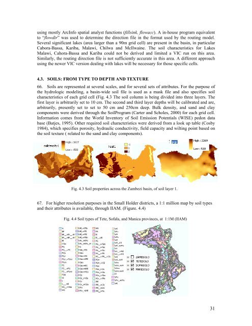
using mostly ArcInfo spatial analyst functions (fillsink, flowacc). A in-house program equivalentto “flowdir” was used to determine the direction file in the format used by the routing model.Several significant lakes (area larger than a 90m grid cell) are present in the basin, in particularCabora-Bassa, Kariba, Malawi, Chilwa and McIlwaine. The soil characteristics for LakesMalawi, Cahora-Bassa and Kariba could not be derived and limited a VIC run on this area.Similarly, the routing direction file is not sufficiently accurate in this area. A different approachusing the newer VIC version dealing with lakes will be necessary for those specific cells.4.3. SOILS: FROM TYPE TO DEPTH AND TEXTURE66. Soils are represented at several scales, and for several sets of attributes. For the purpose ofthe hydrologic modeling, a basin-wide soil file is used as a mask file and also specifies soilcharacteristics of each grid cell (Fig. 4.3 The soil column is being divided into three layers. Thefirst layer is arbitrarily set to 10 cm. The second and third layer depths will be calibrated and are,arbitrarily, presently set to set to 50 cm and 250cm deep. Bulk density, and sand and claycomponents were derived through the SoilProgram (Carter and Scholes, 2000) for each grid cell.Information comes from the World Inventory of Soil Emission Potentials (WISE) pedon database (Batjes, 1995). Other required soil characteristics were derived from a look up table (Cosby1984), which specifies porosity, hydraulic conductivity, field capacity and wilting point based onthe soil texture ( related to the sand and clay components).Fig. 4.3 Soil properties across the Zambezi basin, of soil layer 1.67. For higher resolution purposes in the Small Holder districts, a 1:1 million map by soil typesand their attributes is available, through IIAM. (Figure. 4.4)Fig. 4.4 Soil types of Tete, Sofala, and Manica provinces, at 1:1M (IIAM)31