Aireys Inlet Recreation Infrastructure Strategy ... - Surf Coast Shire
Aireys Inlet Recreation Infrastructure Strategy ... - Surf Coast Shire
Aireys Inlet Recreation Infrastructure Strategy ... - Surf Coast Shire
Create successful ePaper yourself
Turn your PDF publications into a flip-book with our unique Google optimized e-Paper software.
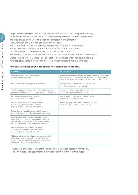
30Part 2 <strong>Infrastructure</strong> Details And OptionsStage 1 identified that the Gilbert Street site was not suitable for the development of playingfields, and its leisure potential lies more with supporting nature or trail based experiences.The sites located on the western side of the Painkalac Creek were foundto be unsuitable due to flooding and environmental issues.The land adjacent to the skate park was deemed unsuitable due to inappropriatezoning, the inability to fill the land, and due to its recent transfer to the GreatOcean Road <strong>Coast</strong>al Committee because of its coastal significance.The primary school site was found unsuitable for a competition playing field, as it was too small.Overall the area west of Bambra Road and east of the Painkalac Creek was determined themost appropriate area in <strong>Aireys</strong> <strong>Inlet</strong> to locate a recreation reserve with a playing field.Advantages and disadvantages of a Bambra Road location are listed below:ADVANTAGESThe largest vacant land, flattest and leastvegetated within <strong>Aireys</strong> <strong>Inlet</strong>Easily accessible from an appropriate sized roadA bushland appearance could still be achieved by ensuringplantation of suitable vegetation around any built infrastructureDISADVANTAGESSituated in a flood plain, much of the land is covered by a flood overlay.This limits where a field could be located and significant earthworkscould be required to increase the level of the field. See Appendix 5.Currently located within Rural Conservation Zoneit would therefore need to be rezonedAn evacuation plan may be required as the thereis dense bushland surrounding the valley<strong>Infrastructure</strong> would not obstruct vistasfrom nearby residential propertiesA recreation reserve in this location may be asubstantially better result than a residentialdwelling, or farming activities in this corridorNearby residents may be concerned by potentialdevelopment in this green corridorPlacing a playing field further back on the land mayresult in a higher cost of services to the siteThe development would be consistent with residentsdesire for this area to be retained as public open spaceA reserve could enable access to the public reservealong the Creek – that is not currently accessible, andfacilitate the construction of the off-road trail plannedfor the creek corridor as per the Pathway <strong>Strategy</strong>This location offers the opportunity to developwetlands and nature based recreation activitiesin conjunction with recreation and sportAdditional catchment and estuarine management workscould occur on the site, as well water harvesting andrecycling. Council has considered possible stormwatermanagement works on this site previouslyFour sites along the east side of the Painkalac Creek were considered in more detail.The advantages and disadvantages of each are described in the following pages.


