- Page 1:
ACTA PHYTOGEOGRAPHICA SUECICAEDIDIT
- Page 4 and 5:
Printed with support fromH. M. King
- Page 11 and 12:
TABLE OF CONTENTSREGIONAL SURVEYFea
- Page 13 and 14:
REGIONAL SURVEYFeatures of Land and
- Page 15 and 16:
Features of land and climate 3Fig.
- Page 17:
Features of land and climate 5bould
- Page 20 and 21:
8 HUGO SJORSFig. 9. The length of d
- Page 22 and 23:
10 HUGO SJORSYearly precipitation i
- Page 24 and 25:
12 HUGO SJORSrainfall, and in winte
- Page 26 and 27:
Fig. 2. On the lee side of an expos
- Page 28 and 29:
16 MATS WJERNmetres below the surfa
- Page 30 and 31:
18 MATS WlERNmon in shallow water,
- Page 32 and 33:
20 MATS W.LERNthe West Coast is cau
- Page 34 and 35:
22 MATS WlERNalways sterile). Ceram
- Page 36 and 37:
24 MATS WlERNparticular species of
- Page 38 and 39:
26 MATS WlERNRich in species. Scatt
- Page 40 and 41:
The Vegetation of Swedish LakesBy G
- Page 42 and 43:
30 GUNNAR LOHAMMARby compact underw
- Page 44 and 45:
32 GUNNAR LOHAMMARmake up only a sm
- Page 46 and 47:
34 GUNN AR LOHAMMARoccur patches of
- Page 48 and 49:
36 GUNNAR LOHAMMARFig . 7. Exposed
- Page 50 and 51:
38 GUNN AR LOHAMMARFig. ll. South s
- Page 52 and 53:
40 GUNN AR LOHAMMARFig. 15. Vastann
- Page 54 and 55:
42 GUNN AR LOHAMMARFig. 19. Lake Ta
- Page 56 and 57:
44:GUNNAR LOHAMMARLappmark it goes
- Page 58 and 59:
46 GUNNAR LOHAMMARice cover. From l
- Page 60 and 61:
Forest RegionsBy HUGO SJO RSA count
- Page 62 and 63:
50HUGO SJORSFig. 2. Biotic zonation
- Page 64 and 65:
52 HUGO SJORSFig. 4. Beech forest w
- Page 66 and 67:
54 HUGO SJORSFig. 6. Coastal oakwoo
- Page 68 and 69:
56HUGO SJORS·the growth of deciduo
- Page 70 and 71:
58HUGO SJORSFig. 8 . . vernal hazel
- Page 72 and 73:
60 HUGO SJORSthrough basal shoots o
- Page 74 and 75:
62 HUGO SJORSdebted to their collea
- Page 76 and 77:
The Mountain Regions of IJapplandBy
- Page 78 and 79:
66 OLOF RUNEplants into low-alpine,
- Page 80 and 81:
68 OLOF RUNEFig. 2. Aconitum septen
- Page 82 and 83:
70OLOF RUNEoccurrences of even more
- Page 84 and 85:
72 OLOF RUNEin flushed sites, e.g.
- Page 86 and 87:
74 OLOF RUNEthe low -alpine vegetat
- Page 88:
76 OLOF RUNETABLE 1. Upper limits (
- Page 95 and 96:
Alpine zonation in the southern par
- Page 97 and 98:
ASPE CTS OF THE SOUTHVertical Zonat
- Page 99 and 100:
Vertical zonation of littoral algae
- Page 101 and 102:
Vertical zonation of littoral algae
- Page 103 and 104:
Vertical zonation of littoral algae
- Page 105 and 106:
Coastal algae oft Goteborg 93., ,.
- Page 107 and 108:
..Coastal algae off Goteborg 95effe
- Page 109 and 110:
Salt Marsh '' egetation In Southern
- Page 111 and 112:
Salt marsh vegetation in southern S
- Page 113 and 114:
Salt marsh vegetation in southern S
- Page 115 and 116:
Salt marsh vegetation in southern S
- Page 117 and 118:
Maritime SandsBy BENGT PETTERSSONAl
- Page 119 and 120:
Maritime sands 107Fig. l. Recently
- Page 121 and 122:
Maritime sands 109Fig. 3. The same
- Page 123 and 124:
Vegetation of Coastal BohusHinBy H.
- Page 125 and 126:
Vegetation of coastal Bohuslan 113F
- Page 127 and 128:
Vegetation of coastal Bohusliin 115
- Page 129 and 130:
Vegetation of coastal Bohusliin 117
- Page 131 and 132:
also on a substratum lacking shells
- Page 133 and 134:
Vegetation of coastal Bohusliin 121
- Page 135 and 136:
The South-Western Dwarf Shrub Heath
- Page 137 and 138:
The south-western dwarf shrub heath
- Page 139 and 140:
The south-western dwarf shrub heath
- Page 141 and 142:
to the Myrica- Cyperaceae fen in AL
- Page 143 and 144:
Gotland and OlandTwo Limestone Isla
- Page 145 and 146:
Gotland and Oland. Two limestone is
- Page 147 and 148:
Gotland and Oland. Two limestone is
- Page 149 and 150:
Gotland and Oland. Two limestone is
- Page 151 and 152:
Gotland and Oland. Two limestone is
- Page 153 and 154:
Woods on the Isle of JungfrunBy IVA
- Page 155 and 156:
Woods on the Isle of Jungfrun 143br
- Page 157 and 158:
EINAR Du RIETZ took an active part
- Page 159 and 160:
The growth on rock 147Fig. 4. Antit
- Page 161 and 162:
The Southern MiresBy NILS MALMERInt
- Page 163 and 164:
The southern mires 151Fig. 2. Woode
- Page 165 and 166:
The southern mires 153Fig. 4. Poor
- Page 167 and 168:
The southern mires 155In addition,
- Page 169 and 170:
the water below the surface is poor
- Page 171 and 172:
Micro-Vegetation of a MireBy TOM FL
- Page 173 and 174:
Stipa pennata and its Companions In
- Page 175 and 176:
Stipa pennata and its companions in
- Page 177 and 178:
Stipa pennata and its companions in
- Page 179 and 180:
ASPECTS OF THE NORTHThe BorderlandB
- Page 181 and 182:
The Borderland169'Fig. 2. The same
- Page 183 and 184:
The marked closeness of the iso-lin
- Page 185 and 186:
The Borderland 173level, much of th
- Page 187 and 188:
The Borderland 175Fig. 4. The Nitte
- Page 189 and 190:
Glimpses of the Bothnian coast 177d
- Page 191 and 192:
Glimpses of the Bothnian coast . 17
- Page 193 and 194:
Regional ecology of mire sites and
- Page 195 and 196: Regional ecology of mire sites and
- Page 197 and 198: Regional ecology of mire sites and
- Page 199 and 200: Regional ecology of mire sites and
- Page 201 and 202: Algfloarna, a mixed mire complex in
- Page 203 and 204: Algjloarna, a mixed mire complex in
- Page 205 and 206: Calcareous fens in J iimtland193CAL
- Page 207 and 208: Calcareous fens in Jamtland 195Fig.
- Page 209 and 210: Calcareous fens in J iimtland 197FE
- Page 211 and 212: The major rivers of Northern Sweden
- Page 213 and 214: The major rivers of Northern Sweden
- Page 215 and 216: The major rivers of Northern Sweden
- Page 217 and 218: The North-East CornerBy ERIK JULIN
- Page 219 and 220: Terrestrial vegetation and flora 20
- Page 221 and 222: Notes on aquatic vegetation 209SPON
- Page 223 and 224: Notes on aquatic vegetation 211Fig.
- Page 225 and 226: Notes on aquatic vegetation 213Fig.
- Page 227 and 228: Lappland East of the MountainsBy JI
- Page 229 and 230: South-facing hills and mountains 21
- Page 231 and 232: Vegetation and flora of alpine outl
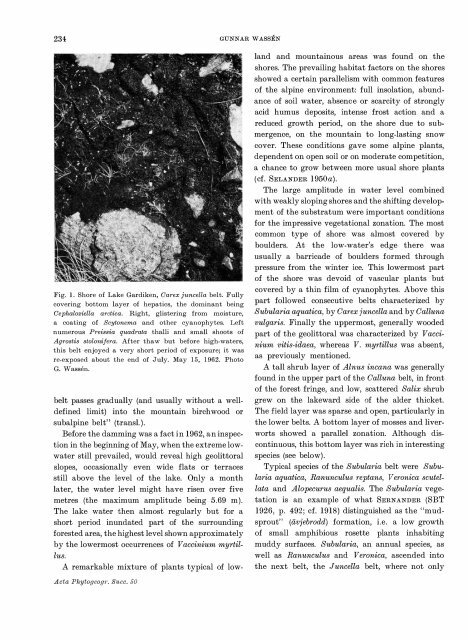
- Page 233 and 234: Regional aspects on the flora 221Fi
- Page 235 and 236: Regional aspects on the flora 223Fi
- Page 237 and 238: Regional a.spects on the flora 225O
- Page 239 and 240: Cultural influence on the flora 227
- Page 241 and 242: Notes on the vegetation of lakes in
- Page 243 and 244: Notes on the vegetation of lakes in
- Page 245: Lost and Living Lakes In the Upper
- Page 249 and 250: P:....,.>::."tl;:3"..,.cc-'!lJ'.J-,
- Page 251 and 252: Lost and living lakes in the upper
- Page 253 and 254: Subalpine tall herb vegetation, sit
- Page 255 and 256: Subalpine tall herb vegetation, sit
- Page 257 and 258: Subalpine tall herb vegetation, sit
- Page 259 and 260: Subalpine tall herb vegetation, sit
- Page 261 and 262: Mountain MiresBy AKE PERSSON1 ntrod
- Page 263 and 264: Mountain mires 251Fig. I. Part of a
- Page 265 and 266: Mountain mires 253Fig. 3. Carex jun
- Page 267 and 268: Mountain mires 255Spring vegetation
- Page 269 and 270: Plant Cover of the Alpine RegionsBy
- Page 271 and 272: low-alpine belt most of the other s
- Page 273 and 274: Ohionophobous plant communities 261
- Page 275 and 276: Ohionophilous plant communities . 2
- Page 277 and 278: Ohionophilous plant communities 265
- Page 279 and 280: The high-alpine region 267as a pred
- Page 281 and 282: PAST AND PRES ENTThe Late-Quaternar
- Page 283 and 284: The Late-Quaternary vegetation of S
- Page 285 and 286: The Late-Quaternary vegetation of S
- Page 287 and 288: The Late-Quaternary vegetation of S
- Page 289 and 290: The Late-Quaternary vegetation of S
- Page 291 and 292: The Late-Quaternary vegetation of S
- Page 293 and 294: Reindeer Grazing ProblemsBy ELIEL S
- Page 295 and 296: Reindeer grazing problems 283Fig. 2
- Page 297 and 298:
Botanical Indications of Air Pollut
- Page 299 and 300:
Botanical indications of air pollut
- Page 301 and 302:
Recent changes in flora and vegetat
- Page 303 and 304:
Recent changes in flora and vegetat
- Page 305 and 306:
Recent changes in flora and vegetat
- Page 307 and 308:
BibliographyBy AK E SJODINThe year
- Page 309 and 310:
Bibliography 297Torfmooren. Diss. -
- Page 311 and 312:
Bibliography 2991934, Jungfrun. - S
- Page 313 and 314:
Bibliography 301(Das Gebiet des Ben
- Page 315 and 316:
Bibliography 303Humiditat des Klima
- Page 317 and 318:
Bibliography 305- 1960, Bidrag till
- Page 319 and 320:
Bibliogmphy 307land. ("Uber die Gef
- Page 321 and 322:
Bibliography 3091958, Dynamik och k
- Page 323 and 324:
Bibliography 311- 1926, Stockholms
- Page 325 and 326:
Bibliography 313- Verh. Int. Verein
- Page 327 and 328:
SVENSI
- Page 332:
Pris 72 kronor Printed in Sweden 19