Create successful ePaper yourself
Turn your PDF publications into a flip-book with our unique Google optimized e-Paper software.
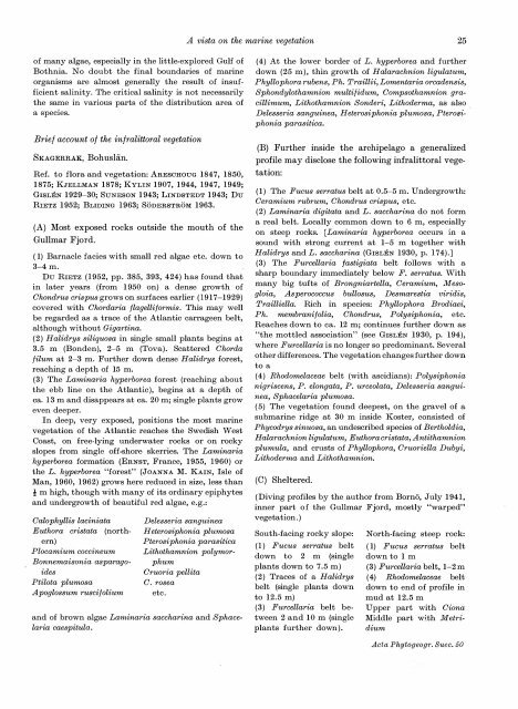
A vista on the marine vegetation 25of many algae, especially in the little-explored Gulf ofBothnia. No doubt the final boundaries of marineorganisms are almost generally the result of insufficientsalinity. The critical salinity is not necessarilythe same in various parts of the distribution area ofa species.Brief account of the infralittoral vegetationSKAGERR.AK, BohusHin.Ref. to flora and vegetation: ARESCHOUG 1847, 1850,1875; KJELLMAN 1878; KYLIN 1907, 1944, 1947, 1949;GISLEN 1929-30; SuNESON 1943; LINDSTEDT 1943; DuRIETZ 1952; BLIDING 1963; SODERSTROM 1963.(A) Most exposed rocks outside the mouth of theGullmar Fjord.( 1) Barnacle facies with small red algae etc. down to3-4 m.Du RIETZ (1952, pp. 385, 393, 424) has found thatin later years (from 1950 on) a dense growth ofChondrus crispus grows on surfaces earlier (1917-1929)covered with Chordaria flagelliformis. This may wellbe regarded as a trace of the Atlantic carrageen belt,although without Gigartina.(2) Halidrys siliquosa in single small plants begins at3.5 m (Bonden), 2-5 m (Tova). Scattered Chordafilum at 2-3 m. Further down dense Halid1·ys forest,reaching a depth of 15 m.(3) The Laminaria hyperborea forest (reaching aboutthe ebb line on the Atlantic), begins at a depth ofea. 13 m and disappears at ea. 20 m; single plants groweven deeper.In deep, very exposed, positions the most marinevegetation of the Atlantic reaches the Swedish WestCoast, on free-lying underwater rocks or on rockyslopes from single_ off-shore skerries. The Laminariahyperborea formation (ERNST, France, 1955, 1960) orthe L. hyperborea "forest" (JOANNA M. KAIN, Isle ofMan, 1960, 1962) grows here reduced in size, less thant m high, though with many of its ordinary epiphytesand undergrowth of beautiful red algae, e.g.:Calophyllis laciniataEuthora cristata (northern)Plocamium coccineumBonnemaisonia asparagoidesPtilota plumosaApoglossum ruscijoliumDelesseria sanguineaH eterosiphonia plumosaPterosiphonia parasiticaLithothamnion polymorphumCruoria pellitaC. roseaetc.and of brown algae Laminaria saccharina and Sphacelariacaespitula.(4) At the lower border of L. hyperborea and furtherdown (25 m), thin growth of Halarachnion ligulatum,Phyllophora rubens, Ph. Traillii, Lomentaria orcadensis,Sphondylothamnion multijidum, Compsothamnion gracillimum,Lithothamnion Sonderi, Lithoderma, as alsoDelesseria sanguinea, Heterosiphonia plumosa, Pterof}iphoniaparasitica.(B) Further inside the . archipelago a generalizedprofile may disclose the following infralittoral vegetation:(1) The Fucus serratus belt at 0.5-5 m. Undergrowth:Ceramium rubrum, Chondrus crispus, etc.(2) Laminaria digitata and L. saccharina do not forma real belt. Locally common down to 6 m, especiallyon steep rocks. [Laminaria hyperborea occurs in asound with strong current at 1-5 m together withHalidrys and L. saccharina (GISLEN 1930, p. 174).](3) The Furcellaria jastigiata belt follows with asharp boundary immediately below F. serratus. Withmany big tufts of Brongniartella, Ceramium, Mesogloia,Asperococcus bullosus, Desmarestia viridis,Trailliella. Rich in species: Phyllophora Brodiaei,Ph. membranifolia, Chondrus, Polysiphonia, etc.Reaches down to ea. 12 m; continues further down as"the mottled association" (see GISLEN 1930, p. 194),where Furcellaria is no longer so predominant. Severalother differences. The vegetation changes further downto a(4) Rhodomelaceae belt (with ascidians): Polysiphonianigriscens, P. elongata, P. urceolata, Delesseria sanguinea,Sphacelaria plumosa.( 5) The vegetation found deepest, on the gravel of asubmarine ridge at 30 m inside Koster, consisted ofPhycodrys sinuosa, an undescribed species of Bertholdia,H alarachnion ligulatum, Euthora cristata, A ntithamnionplumula, and crusts of Phyllophora, Cruoriella Dubyi,Lithoderma and Lithothamnion.(C) Sheltered.(Diving profiles by the author from Borno, July 1941,inner part of the Gullmar Fjord, mostly "warped"vegetation.)South-facing rocky slope:( 1) Fucus serratus beltdown to 2 m (singleplants down to 7.5 m)(2) Traces of a Halidrysbelt (single plants downto 12.5 m)(3) Furcellaria belt between2 and 10 m (singleplants further down).North-facing steep rock:( 1) Fucus serratus beltdown to 1 m(3) Furcellaria belt, 1-2 m( 4) Rhodomelaceae beltdown to end of profile inmud at 12.5 mUpper part with CionaMiddle part with MetridiumActa Phytogeogr. Suec. 50


