Researcher's Guide to Sutter's Fort's Collections of Donner Party ...
Researcher's Guide to Sutter's Fort's Collections of Donner Party ...
Researcher's Guide to Sutter's Fort's Collections of Donner Party ...

Create successful ePaper yourself
Turn your PDF publications into a flip-book with our unique Google optimized e-Paper software.
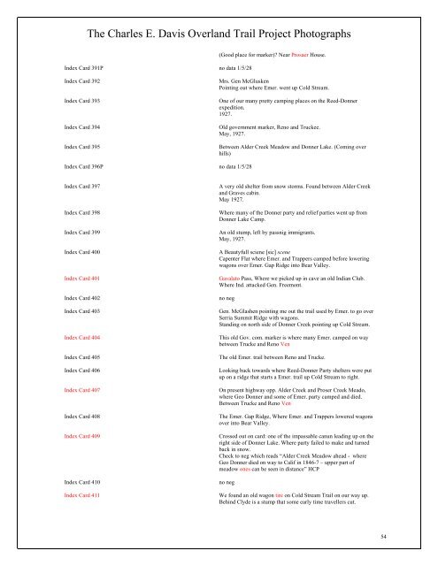
The Charles E. Davis Overland Trail Project Pho<strong>to</strong>graphs<br />
Index Card 391P no data 1/5/28<br />
(Good place for marker)? Near Prosaer House.<br />
Index Card 392 Mrs. Gen McGlusken<br />
Pointing out where Emer. went up Cold Stream.<br />
Index Card 393 One <strong>of</strong> our many pretty camping places on the Reed-<strong>Donner</strong><br />
expedition.<br />
1927.<br />
Index Card 394 Old government marker, Reno and Truckee.<br />
May, 1927.<br />
Index Card 395 Between Alder Creek Meadow and <strong>Donner</strong> Lake. (Coming over<br />
hills)<br />
Index Card 396P no data 1/5/28<br />
Index Card 397 A very old shelter from snow s<strong>to</strong>rms. Found between Alder Creek<br />
and Graves cabin.<br />
May 1927.<br />
Index Card 398 Where many <strong>of</strong> the <strong>Donner</strong> party and relief parties went up from<br />
<strong>Donner</strong> Lake Camp.<br />
Index Card 399 An old stump, left by passnig immigrants.<br />
May, 1927.<br />
Index Card 400 A Beautyfull sciene [sic] scene<br />
Capenter Flat where Emer. and Trappers camped before lowering<br />
wagons over Emer. Gap Ridge in<strong>to</strong> Bear Valley.<br />
Index Card 401 Gavala<strong>to</strong> Pass, Where we picked up in cave an old Indian Club.<br />
Where Ind. attacked Gen. Freemont.<br />
Index Card 402 no neg<br />
Index Card 403 Gen. McGlashen pointing me out the trail used by Emer. <strong>to</strong> go over<br />
Serria Summit Ridge with wagons.<br />
Standing on north side <strong>of</strong> <strong>Donner</strong> Creek pointing up Cold Stream.<br />
Index Card 404 This old Gov. com. marker is where many Emer. camped on way<br />
between Trucke and Reno Ven<br />
Index Card 405 The old Emer. trail between Reno and Trucke.<br />
Index Card 406 Looking back <strong>to</strong>wards where Reed-<strong>Donner</strong> <strong>Party</strong> shelters were put<br />
up on a ridge that starts a Emer. trail up Cold Stream <strong>to</strong> right.<br />
Index Card 407 On present highway opp. Alder Creek and Proser Creek Meado,<br />
where Geo <strong>Donner</strong> and some <strong>of</strong> Emer. party camped and died.<br />
Between Trucke and Reno Ven<br />
Index Card 408 The Emer. Gap Ridge, Where Emer. and Trappers lowered wagons<br />
over in<strong>to</strong> Bear Valley.<br />
Index Card 409 Crossed out on card: one <strong>of</strong> the impassable canun leading up on the<br />
right side <strong>of</strong> <strong>Donner</strong> Lake. Where party failed <strong>to</strong> make and turned<br />
back in snow.<br />
Check <strong>to</strong> neg which reads “Alder Creek Meadow ahead - where<br />
Geo <strong>Donner</strong> died on way <strong>to</strong> Calif in 1846-7 – upper part <strong>of</strong><br />
meadow ones can be seen in distance” HCP<br />
Index Card 410 no neg<br />
Index Card 411 We found an old wagon tire on Cold Stream Trail on our way up.<br />
Behind Clyde is a stump that some early time travellers cut.<br />
54