

GEOmedia_3_2018
GEOmedia - the first Italian magazine on geomatics
GEOmedia - the first Italian magazine on geomatics

You also want an ePaper? Increase the reach of your titles
YUMPU automatically turns print PDFs into web optimized ePapers that Google loves.
REPORT<br />
Copernicus Sentinels missions and<br />
crowdsourcing as game changers for<br />
geospatial information in agriculture<br />
by Flavio Lupia, Vyron Antoniou<br />
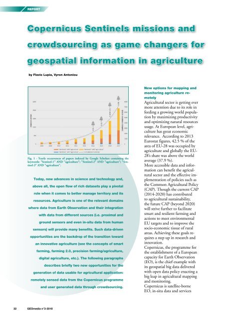
Fig. 1 - Yearly occurrences of papers indexed by Google Scholars containing the<br />
keywords: "Sentinel-1" AND "agriculture"; "Sentinel-2" AND "agriculture"; "Sentinel-3"<br />
AND "agriculture".<br />
Today, new advances in science and technology and,<br />
above all, the open flow of rich datasets play a pivotal<br />
role when it comes to better manage territory and its<br />
resources. Agriculture is one of the relevant domains<br />
where data from Earth Observation and their integration<br />
with data from different sources (i.e. proximal and<br />
ground sensors and even in-situ data from human<br />
sensors) will provide many benefits. Such data-driven<br />
opportunities are the backdrop of the transition toward<br />
an innovative agriculture (see the concepts of smart<br />
farming, farming 2.0, precision farming/agriculture,<br />
digital agriculture, etc.). The following paragraphs<br />
describes briefly two new opportunities for the<br />
generation of data usable for agricultural application:<br />
remotely sensed data from the Copernicus programme<br />
and user generated data through crowdsourcing.<br />
New options for mapping and<br />
monitoring agriculture remotely<br />
Agricultural sector is getting ever<br />
more attention due to its role in<br />
feeding a growing world population<br />
by maximizing productivity<br />
and optimizing natural resources<br />
usage. At European level, agriculture<br />
has great economic<br />
relevance. According to 2013<br />
Eurostat figures, 42.5 % of the<br />
area of EU-28 was occupied by<br />
agriculture and globally the EU-<br />
28’s share was above the world<br />
average (37.9 %).<br />
More accessible data and information<br />
can benefit the agricultural<br />
sector and the effective implementation<br />
of policies such as<br />
the Common Agricultural Policy<br />
(CAP). Though the current CAP<br />
(2014-2020) has contributed<br />
to agricultural sustainability,<br />
the future CAP (beyond 2020)<br />
will strive further to facilitate<br />
smart and resilient farming and<br />
actions to meet environmental<br />
EU targets and to improve the<br />
socio-economic tissue of rural<br />
areas. Achieving these goals requires<br />
a step up in research and<br />
innovation.<br />
Copernicus, the programme for<br />
the establishment of a European<br />
capacity for Earth Observation<br />
(EO), is the chief example with<br />
its geospatial big data delivered<br />
with open data policy enacting a<br />
big leap in agricultural mapping<br />
and monitoring.<br />
Copernicus is satellite-borne<br />
EO, in-situ data and services<br />
32 <strong>GEOmedia</strong> n°3-<strong>2018</strong>


