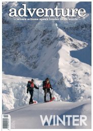
Adventure Magazine April 2020
Issue #219 Survival Issue April is always our survival issue - seems fitting this year. How to survive an eruption, survive Everest, survive a Great White encounter and more.
Issue #219 Survival Issue
April is always our survival issue - seems fitting this year.
How to survive an eruption, survive Everest, survive a Great White encounter and more.

You also want an ePaper? Increase the reach of your titles
YUMPU automatically turns print PDFs into web optimized ePapers that Google loves.
Silica Rapids<br />
This highly varied walk travels<br />
through mountain beech forest and<br />
alongside a cascading stream to arrive<br />
at the creamy-white terraces of the<br />
Silica Rapids. A range of vegetation<br />
types, including subalpine plants,<br />
amid a mixture of swamp and tussock<br />
country, feature around the track. On a<br />
clear day, the walk offers spectacular<br />
views of Ruapehu and Ngauruhoe.<br />
The track begins 250 metres above<br />
Whakapapa Village Visitor Centre and<br />
returns along Bruce Road for 2.5km - or<br />
return along the same track.<br />
Distance: 7 km return via Bruce Rd<br />
Grade: Easy<br />
Tupapakurua Falls<br />
One of the lesser discovered hikes<br />
in the area, but also one of the more<br />
challenging, the Tupapakurua Falls<br />
track can be reached from National<br />
Park Village. It starts off Fishers Road<br />
and begins with an easy 20-minute<br />
walk to the Taranaki lookout from<br />
where you can view Mt Taranaki on a<br />
clear day. From there, it becomes a<br />
back-country adventure track suitable<br />
for experienced hikers only. The track<br />
follows a ridge and then descends<br />
steeply to a stream with good stands<br />
of native trees, including tawa, mature<br />
rimu, miro and totara, along the way.<br />
Climbing from the stream, the track<br />
winds its way around bluffs to a good<br />
lookout point with views of the falls.<br />
Allow between 4 to 5 hours for the<br />
return trip.<br />
Distance: 11km<br />
Grade: Moderate to difficult<br />
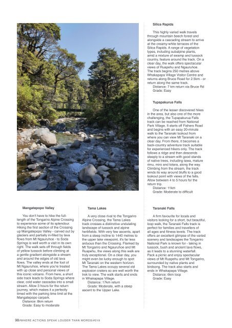
Mangatepopo Valley<br />
You don't have to hike the fulllength<br />
of the Tongariro Alpine Crossing<br />
to experience some of its splendour.<br />
Hiking the first section of the Crossing<br />
up Mangatepopo Valley - carved out by<br />
glaciers and partially in-filled by lava<br />
flows from Mt Ngauruhoe - to Soda<br />
Springs is well worth a visit in its own<br />
right. The walk sets off through fields<br />
of yellow tussock before climbing at<br />
a gentle gradient alongside a stream<br />
and around the edges of old lava<br />
flows. The valley ends at the foot of<br />
Mt Ngauruhoe, where you're treated<br />
with up close and personal views of<br />
this iconic volcano. From here, a short<br />
side track leads to Soda Springs where<br />
clear, cold water cascades into a small<br />
stream. Allow 3 hours for the return<br />
journey, which makes it a perfectly<br />
timed with the parking time limit at the<br />
Mangatepopo carpark.<br />
Distance: 8km return<br />
Grade: Easy to moderate<br />
Tama Lakes<br />
A very close rival to the Tongariro<br />
Alpine Crossing, the Tama Lakes<br />
track crosses a distinctive undulating<br />
landscape of tussock and alpine<br />
herbfields. With very few ascents, apart<br />
from a steep incline to 1440 metres to<br />
the upper lake viewpoint, it's far less<br />
arduous than the Crossing. Flanked by<br />
Mt Tongariro and Ngauruhoe and Mt<br />
Ruapehu, the views along this walk are<br />
truly exceptional. On a clear day, you<br />
might even be lucky enough to spot<br />
Mt Taranaki on the western horizon.<br />
The Tama Lakes occupy several old<br />
explosion craters so are well worth the<br />
trek to view. The walk starts and ends<br />
in Whakapapa Village.<br />
Distance: 17km return<br />
Grade: Moderate, with a steep<br />
ascent to the Upper Lake.<br />
Taranaki Falls<br />
A firm favourite for locals and<br />
visitors looking for a short, but beautiful,<br />
loop walk, the Taranaki Falls track is<br />
perfect for families and travellers of<br />
all ages and fitness levels. The track<br />
offers an excellent glimpse of the varied<br />
scenery and landscapes the Tongariro<br />
National Park is known for - taking in<br />
tussock, bush and ancient lava flows,<br />
as it leads to a stunning waterfall.<br />
Pack a picnic and enjoy spectacular<br />
views of Mt Ruapehu and Mt Tongariro,<br />
surrounded by native plants and<br />
birdsong. The track also starts and<br />
ends in Whakapapa Village.<br />
Distance: 6km loop<br />
Grade: Easy<br />
98//WHERE ACTIONS SPEAK LOUDER THAN WORDS/#219