


You also want an ePaper? Increase the reach of your titles
YUMPU automatically turns print PDFs into web optimized ePapers that Google loves.
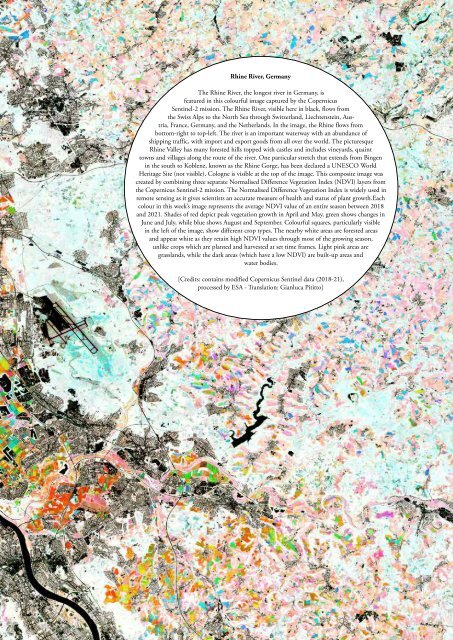
Rhine River, Germany<br />
The Rhine River, the longest river in Germany, is<br />
featured in this colourful image captured by the Copernicus<br />
Sentinel-2 mission. The Rhine River, visible here in black, flows from<br />
the Swiss Alps to the North Sea through Switzerland, Liechtenstein, Austria,<br />
France, Germany, and the Netherlands. In the image, the Rhine flows from<br />
bottom-right to top-left. The river is an important waterway with an abundance of<br />
shipping traffic, with import and export goods from all over the world. The picturesque<br />
Rhine Valley has many forested hills topped with castles and includes vineyards, quaint<br />
towns and villages along the route of the river. One particular stretch that extends from Bingen<br />
in the south to Koblenz, known as the Rhine Gorge, has been declared a UNESCO World<br />
Heritage Site (not visible). Cologne is visible at the top of the image. This composite image was<br />
created by combining three separate Normalised Difference Vegetation Index (NDVI) layers from<br />
the Copernicus Sentinel-2 mission. The Normalised Difference Vegetation Index is widely used in<br />
remote sensing as it gives scientists an accurate measure of health and status of plant growth.Each<br />
colour in this week’s image represents the average NDVI value of an entire season between 2018<br />
and 2021. Shades of red depict peak vegetation growth in April and May, green shows changes in<br />
June and July, while blue shows August and September. Colourful squares, particularly visible<br />
in the left of the image, show different crop types. The nearby white areas are forested areas<br />
and appear white as they retain high NDVI values through most of the growing season,<br />
unlike crops which are planted and harvested at set time frames. Light pink areas are<br />
grasslands, while the dark areas (which have a low NDVI) are built-up areas and<br />
water bodies.<br />
[Credits: contains modified Copernicus Sentinel data (2018-21),<br />
processed by ESA - Translation: Gianluca Pititto]


