4 Final Report - Emits - ESA
4 Final Report - Emits - ESA
4 Final Report - Emits - ESA

You also want an ePaper? Increase the reach of your titles
YUMPU automatically turns print PDFs into web optimized ePapers that Google loves.
2 <strong>Final</strong><br />
<strong>Report</strong><br />
15 min. These requirements are not possible to be fulfilled by LEO missions and underline the<br />
strengths of the GeoOculus mission.<br />
The primary region of service provision is the European mainland, nevertheless can it be considered<br />
to provide this service for the whole visible regions (e.g. Africa) with reduced priority to avoid<br />
interruption of other services.<br />
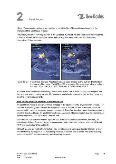
Figure 2.3-2: Forest fires near Los Angeles in October 2003 imaged by the DLR BIRD satellite in<br />
the course of 24 hours. The GSD is 185 m squared. The scale is as follows: yellow =<br />
0,1 MW / Pixel; orange = 1 MW / Pixel; red = 10 MW / Pixel. © DLR<br />
Additional observations of manifold high temperature events, like volcanic activity, tropical peat land<br />
fires and coal seams, mainly for scientific purposes, shall also be covered by this service; hence not<br />
drive the system requirements.<br />
Algal Bloom Detection Service - Primary Objective<br />
An algal bloom refers to a quick and local increase in the abundance of a phytoplankton species. The<br />
so-called Harmful Algal Blooms (HAB) are special cases of the former, with deleterious effects on<br />
human health or marine resources (natural or cultured). Therefore the algal bloom detection service is<br />
aimed to detect and locate an algal bloom in European waters. This information shall be incorporated<br />
into the respective GSE MARCOAST service line.<br />
Users include national environment agencies and fisheries industries (aquaculture, shellfish). All<br />
coastal and offshore European waters are concerned (region enclosed between latitudes 35°N and<br />
70° N and longitudes 12°W and 30°E).<br />
Although blooms are relatively well detected by remote sensing technique, the identification of their<br />
possible toxicity from space is far from being achieved. Satellites play a crucial role for forecasting<br />
(combination of EO data with models) and visualising the extent.<br />
Doc. No: GOC-ASG-RP-002 Page 2-5<br />
Issue: 2<br />
Date: 13.05.2009 Astrium GmbH