4 Final Report - Emits - ESA
4 Final Report - Emits - ESA
4 Final Report - Emits - ESA

Create successful ePaper yourself
Turn your PDF publications into a flip-book with our unique Google optimized e-Paper software.
4 <strong>Final</strong><br />
<strong>Report</strong><br />
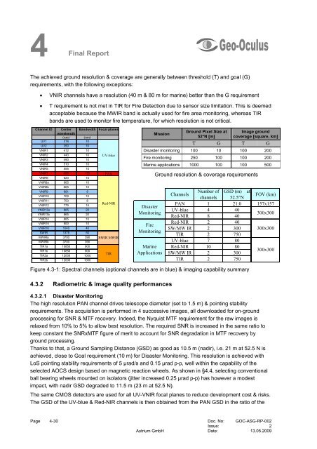
The achieved ground resolution & coverage are generally between threshold (T) and goal (G)<br />
requirements, with the following exceptions:<br />
• VNIR channels have a resolution (40 m & 80 m for marine) better than the G requirement<br />
• T requirement is not met in TIR for Fire Detection due to sensor size limitation. This is deemed<br />
acceptable because the MWIR band is actually used for fire area monitoring, whereas TIR<br />
bands are used to monitor fire temperature, for which resolution is not critical.<br />
Channel ID Center<br />
wavelength<br />
Bandwidth Focal planes<br />
(nm) (nm)<br />
UV1 318 10<br />
UV2 350 10<br />
VNIR1 412 10<br />
VNIR2 443 10 UV-blue<br />
VNIR3 490 10<br />
VNIR4 510 10<br />
VNIR5 555 10<br />
VNIR7 655 155 PAN<br />
VNIR6 620 10<br />
VNIR8a 665 10<br />
VNIR8b 665 10<br />
VNIR9 681 8<br />
VNIR10 709 10<br />
VNIR11<br />
VNIR12<br />
753<br />
779<br />
8<br />
15<br />
Red-NIR<br />
VNIR13a 865 20<br />
VNIR13b 865 20<br />
VNIR14 885 10<br />
VNIR15 900 10<br />
VNIR16 1040 40<br />
SWIR 1375 50<br />
MWIRa 3700 390 SWIR MWIR<br />
MWIRb 3700 390<br />
TIR1a 10850 900<br />
TIR1b<br />
TIR2a<br />
10850<br />
12000<br />
900<br />
1000<br />
TIR<br />
TIR2b 12000 1000<br />
Mission<br />
Disaster<br />
Monitoring<br />
Fire<br />
Monitoring<br />
Marine<br />
Applications<br />
Figure 4.3-1: Spectral channels (optional channels are in blue) & imaging capability summary<br />
4.3.2 Radiometric & image quality performances<br />
Ground Pixel Size at<br />
52°N [m]<br />
Image ground<br />
coverage [square, km]<br />
T G T G<br />
Disaster monitoring 100 10 100 200<br />
Fire monitoring 250 100 100 200<br />
Marine applications 1000 100 100 500<br />
Ground resolution & coverage requirements<br />
Channels<br />
Number of<br />
channels<br />
GSD (m) at<br />
52.5°N<br />
FOV (km)<br />
PAN 1 21.0 157x157<br />
UV-blue<br />
Red-NIR<br />
4<br />
8<br />
40<br />
40<br />
300x300<br />
Red-NIR 2 40<br />
SW/MW IR 2 300 300x300<br />
TIR 2 750<br />
UV-blue 7 80<br />
Red-NIR<br />
SW/MW IR<br />
10<br />
2<br />
80<br />
300<br />
300x300<br />
TIR 2 750<br />
4.3.2.1 Disaster Monitoring<br />
The high resolution PAN channel drives telescope diameter (set to 1.5 m) & pointing stability<br />
requirements. The acquisition is performed in 4 successive images, all downloaded for on-ground<br />
processing for SNR & MTF recovery. Indeed, the Nyquist MTF requirement for the raw images is<br />
relaxed from 10% to 5% to allow best resolution. The required SNR is increased in the same ratio to<br />
keep constant the SNRxMTF figure of merit to account for SNR degradation in MTF recovery by<br />
ground processing.<br />
Thanks to that, a Ground Sampling Distance (GSD) as good as 10.5 m (nadir), i.e. 21 m at 52.5 N is<br />
achieved, close to Goal requirement (10 m) for Disaster Monitoring. This resolution is achieved with<br />
LoS pointing stability requirements of 5 µrad/s and 0.15 µrad p-p, well within the capability of the<br />
selected AOCS design based on magnetic reaction wheels. As shown in §4.4, selecting conventional<br />
ball bearing wheels mounted on isolators (jitter increased 0.25 µrad p-p) has however a modest<br />
impact, with nadir GSD degraded to 11.5 m (23 m at 52.5 N).<br />
The same CMOS detectors are used for all UV-VNIR focal planes to reduce development cost & risks.<br />
The GSD of the UV-blue & Red-NIR channels is then obtained from the PAN GSD in the ratio of the<br />
Page 4-30 Doc. No: GOC-ASG-RP-002<br />
Issue: 2<br />
Astrium GmbH Date: 13.05.2009