After the Flood in Pakistan 38 Berlin Geographical Papers - Freie ...
After the Flood in Pakistan 38 Berlin Geographical Papers - Freie ...
After the Flood in Pakistan 38 Berlin Geographical Papers - Freie ...

You also want an ePaper? Increase the reach of your titles
YUMPU automatically turns print PDFs into web optimized ePapers that Google loves.
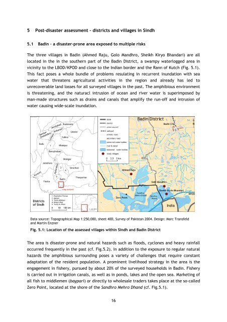
5 Post-disaster assessment – districts and villages <strong>in</strong> S<strong>in</strong>dh<br />
5.1 Bad<strong>in</strong> – a disaster-prone area exposed to multiple risks<br />
The three villages <strong>in</strong> Bad<strong>in</strong> (Ahmed Raju, Golo Mandhro, Sheikh Kiryo Bhandari) are all<br />
located <strong>in</strong> <strong>the</strong> <strong>in</strong> <strong>the</strong> sou<strong>the</strong>rn part of <strong>the</strong> Bad<strong>in</strong> District, a swampy waterlogged area <strong>in</strong><br />
vic<strong>in</strong>ity to <strong>the</strong> LBOD/KPOD and close to <strong>the</strong> Indian border and <strong>the</strong> Rann of Kutch (Fig. 5.1).<br />
This fact poses a whole bundle of problems resulat<strong>in</strong>g <strong>in</strong> recurrent <strong>in</strong>undation with sea<br />
water that threatens agricultural activities <strong>in</strong> <strong>the</strong> region and already has led to<br />
unrecoverable land losses for all surveyed villages <strong>in</strong> <strong>the</strong> past. The amphibious environment<br />
is threaten<strong>in</strong>g, and <strong>the</strong> naturacl <strong>in</strong>trusion of ocean and river water is superimposed by<br />
man-made structures such as dra<strong>in</strong>s and canals that amplify <strong>the</strong> run-off and <strong>in</strong>trusion of<br />
water caus<strong>in</strong>g wide-scale <strong>in</strong>undation.<br />
Data source: Topographical Map 1:250,000, sheet 40D, Survey of <strong>Pakistan</strong> 2004. Design: Marc Transfeld<br />
and Mart<strong>in</strong> Enzner<br />
Fig. 5.1: Location of <strong>the</strong> assessed villages with<strong>in</strong> S<strong>in</strong>dh and Bad<strong>in</strong> District<br />
The area is disaster-prone and natural hazards such as floods, cyclones and heavy ra<strong>in</strong>fall<br />
occurred frequently <strong>in</strong> <strong>the</strong> past (cf. Fig.5.2). In addition to <strong>the</strong> exposure to regular natural<br />
hazards <strong>the</strong> amphibious surround<strong>in</strong>g poses a variety of challenges that require constant<br />
adaptation of <strong>the</strong> resident population. A prom<strong>in</strong>ent livelihood strategy <strong>in</strong> <strong>the</strong> area is <strong>the</strong><br />
engagement <strong>in</strong> fishery, pursued by about 20% of <strong>the</strong> surveyed households <strong>in</strong> Bad<strong>in</strong>. Fishery<br />
is carried out <strong>in</strong> irrigation canals, as well as <strong>in</strong> ponds, lakes and <strong>the</strong> open sea. Market<strong>in</strong>g of<br />
all fish to middlemen (baypari) or directly to wholesale traders takes place at <strong>the</strong> so-called<br />
Zero Po<strong>in</strong>t, located at <strong>the</strong> shore of <strong>the</strong> Sandhro Mehro Dhand (cf. Fig.5.1).<br />
16