Physical Density and Urban Sprawl: A Case of Dhaka City - KTH
Physical Density and Urban Sprawl: A Case of Dhaka City - KTH
Physical Density and Urban Sprawl: A Case of Dhaka City - KTH

You also want an ePaper? Increase the reach of your titles
YUMPU automatically turns print PDFs into web optimized ePapers that Google loves.
should be a functioning unit, be investigated in its natural context with a multitude <strong>of</strong><br />
methods, <strong>and</strong> be contemporary” (Johansson 2005:31). He further notes that a case study <strong>and</strong>,<br />
normally, history focuses on one case but simultaneously take account <strong>of</strong> the context, <strong>and</strong> so<br />
encompass many variables <strong>and</strong> qualities.<br />
The main aim <strong>of</strong> the study is to explore the relationship between physical densities, spatial<br />
qualities <strong>and</strong> urban sprawl within the context formal <strong>and</strong> informal settlements <strong>of</strong> <strong>Dhaka</strong> city.<br />
Eight housing settlements, six from formal <strong>and</strong> two from informal settlement, <strong>and</strong> their<br />
components <strong>of</strong> physical densities <strong>and</strong> spatial qualities were selected. Data was collected <strong>and</strong><br />
analysed for each study area.<br />
1.4.2 Why <strong>Dhaka</strong> is selected as a case areas<br />
The present study regards the physical densities <strong>and</strong> spatial qualities <strong>of</strong> housing settlements<br />
as well as their impact on urban sprawl. <strong>Dhaka</strong> is the capital city <strong>of</strong> Bangladesh.<br />
Approximately, 56% percent <strong>of</strong> the <strong>Dhaka</strong> city’s population lives in informal housing<br />
(Titumir <strong>and</strong> Hossain, 2004). There are 3007 small to large informal housing settlements with<br />
10 or more house clusters covering area <strong>of</strong> 420 hectares in different parts <strong>of</strong> <strong>Dhaka</strong><br />
(CUS,1996). The built up area is increasing rapidly due to the development <strong>of</strong> informal<br />
settlements in the inner part <strong>and</strong> in the periphery <strong>of</strong> the city. Between 1990 <strong>and</strong> 2000, the<br />
built-up area <strong>of</strong> <strong>Dhaka</strong> Metropolitan area has increased by around 46% (JICA Baseline Study,<br />
2000 in Azam, 2006). The expansion <strong>of</strong> the city is occurring both horizontally <strong>and</strong> vertically<br />
due to the development <strong>of</strong> formal <strong>and</strong> informal housing settlements.<br />
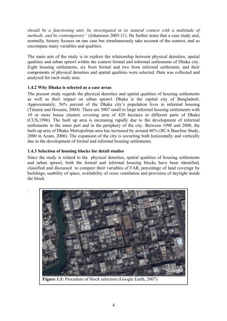
1.4.3 Selection <strong>of</strong> housing blocks for detail studies<br />
Since the study is related to the physical densities, spatial qualities <strong>of</strong> housing settlements<br />
<strong>and</strong> urban sprawl, both the formal <strong>and</strong> informal housing blocks have been identified,<br />
classified <strong>and</strong> discussed to compare their variables <strong>of</strong> FAR, percentage <strong>of</strong> l<strong>and</strong> coverage by<br />
buildings; usability <strong>of</strong> space, availability <strong>of</strong> cross ventilation <strong>and</strong> provision <strong>of</strong> daylight inside<br />
the block.<br />
.<br />
Figure 1.1: Procedure <strong>of</strong> block selection (Google Earth, 2007)<br />
4