Physical Density and Urban Sprawl: A Case of Dhaka City - KTH
Physical Density and Urban Sprawl: A Case of Dhaka City - KTH
Physical Density and Urban Sprawl: A Case of Dhaka City - KTH

You also want an ePaper? Increase the reach of your titles
YUMPU automatically turns print PDFs into web optimized ePapers that Google loves.
indicates the area <strong>of</strong> block including half <strong>of</strong> its surrounding road width. The built area means<br />
the total floor area <strong>of</strong> all buildings which is based on the actual floor area including wall<br />
thickness <strong>of</strong> each structure, <strong>and</strong> multiplied by the number <strong>of</strong> floors. Figure 1.5 is showing the<br />
calculation <strong>of</strong> the total floor area <strong>of</strong> a building. The total floor area inside the block will be<br />
the addition <strong>of</strong> the total floor area <strong>of</strong> all buildings inside the block.<br />
In the figure 1.5<br />
Floor Area, A = L X W unit square<br />
So, Total Floor Area occupied by this building, A1 = A X 5 unit square (Since the building is<br />
5 storeys)<br />
If the total floor area <strong>of</strong> all buildings inside the block = A2 (Addition <strong>of</strong> the total floor area <strong>of</strong><br />
all buildings inside the block) then Floor Area Ratio (FAR) = A2/BA<br />
Analysis <strong>of</strong> <strong>of</strong>ficial documents<br />
Previous study reports or evaluation <strong>of</strong> the same study area, administrative documents, news<br />
paper clipping, other articles appearing in the mass media have been collected from the<br />
internet or other secondary sources. The change <strong>of</strong> spatial patterns <strong>and</strong> growth due to develop<br />
informal settlements have been analysed from the <strong>of</strong>ficial documents.<br />
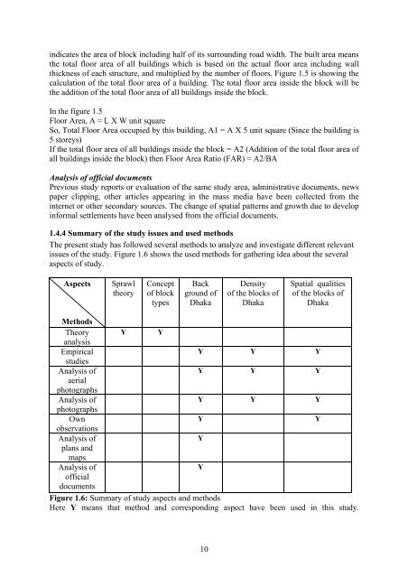
1.4.4 Summary <strong>of</strong> the study issues <strong>and</strong> used methods<br />
The present study has followed several methods to analyze <strong>and</strong> investigate different relevant<br />
issues <strong>of</strong> the study. Figure 1.6 shows the used methods for gathering idea about the several<br />
aspects <strong>of</strong> study.<br />
Aspects<br />
<strong>Sprawl</strong><br />
theory<br />
Concept<br />
<strong>of</strong> block<br />
types<br />
Back<br />
ground <strong>of</strong><br />
<strong>Dhaka</strong><br />
Methods<br />
Theory<br />
analysis<br />
Y Y<br />
Empirical<br />
studies<br />
Y Y Y<br />
Analysis <strong>of</strong><br />
aerial<br />
photographs<br />
Y Y Y<br />
Analysis <strong>of</strong><br />
photographs<br />
Y Y Y<br />
Own<br />
observations<br />
Y Y<br />
Analysis <strong>of</strong><br />
plans <strong>and</strong><br />
maps<br />
Y<br />
Analysis <strong>of</strong><br />
<strong>of</strong>ficial<br />
documents<br />
Y<br />
Figure 1.6: Summary <strong>of</strong> study aspects <strong>and</strong> methods<br />
Here Y means that method <strong>and</strong> corresponding aspect have been used in this study.<br />
10<br />
<strong>Density</strong><br />
<strong>of</strong> the blocks <strong>of</strong><br />
<strong>Dhaka</strong><br />
Spatial qualities<br />
<strong>of</strong> the blocks <strong>of</strong><br />
<strong>Dhaka</strong>