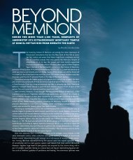
NaraNjo-Sa'al - World Monuments Fund
NaraNjo-Sa'al - World Monuments Fund
NaraNjo-Sa'al - World Monuments Fund

You also want an ePaper? Increase the reach of your titles
YUMPU automatically turns print PDFs into web optimized ePapers that Google loves.
Since 2002, however, Naranjo-Sa’al has been the subject of an intense documentation,<br />
stabilization, and conservation effort, which is revealing a city that grew and prospered over<br />
a period of more than fourteen centuries—from the pre-dawn years of the Maya era ca. 600<br />
b.c. to a.d. 830. Perhaps more important, the site is offering an unprecedented opportunity<br />
to preserve and present a once-great Maya metropolis within the context of its natural<br />
environment.<br />
Located within the boundary of the Yaxhá-Nakum-Naranjo National Park, a<br />
1,200-square-kilometer (460-square-mile) [Figure 3] protected area of forest and wetland<br />
habitat established by the Government of Guatemala in 1999, Naranjo-Sa’al lies between<br />
the drainage areas of the Holmul and Mopán Rivers—natural waterways that afforded the<br />
city with ready access to fertile agricultural lands in Belize and with trading communities<br />
along the Caribbean coast. Today, the site’s vast ruins lie within an extraordinary biodiversity<br />
zone that boasts numerous rare and exotic plant species, some 50 of which are on the<br />
IUCN Red List, as well as endemic animals currently under threat of extinction, among<br />
them Morelet’s crocodile (Crocodylus moreletii), the howler monkey (Alouatta pigra), the<br />
black-handed spider monkey (Ateles geoffroyi), the jaguar (Panthera onca), the puma (Felis<br />
concolor), and the margay (Leopardus wiedii).<br />
In taking a holistic approach to the preservation of this important site as a “garden city”<br />
within its natural environment—in contrast to the heavy handed restoration and forest<br />
clearing programs carried out decades ago at sites such as Tikal—the Naranjo-Sa’al Project<br />
has the potential to serve as a model for future archaeological projects undertaken in ecologically<br />
sensitive areas not only in the Maya region but around the world.<br />
Sin embargo, desde el año 2002, Naranjo-Sa’al ha sido motivo de un intenso esfuerzo<br />
de documentación, estabilización y conservación por parte del Instituto de<br />
Antropología e Historia del Ministerio de Cultura y Deportes que está revelando una<br />
ciudad que creció y prosperó en un periodo de más de catorce siglos—desde antes de<br />
los albores de la era maya, aprox. 600 a.C. hasta el año 830 d.C. Quizás sea aún más<br />
importante el hecho de que este lugar nos está brindando una oportunidad sin precedentes<br />
para conservar y presentar una metrópolis maya de inmensa importancia en el<br />
contexto de su entorno natural.<br />
Naranjo-Sa’al se encuentra dentro de los confines del Parque Nacional Yaxhá-<br />
Nakum-Naranjo, un área protegida de selva con un hábitat de humedales que abarca<br />
1,200-kilómetros cuadrados (460 millas cuadradas) [Figura 3]. Esta área protegida fue<br />
creada por el gobierno de Guatemala en 1999 y se ubica entre las zonas de drenaje<br />
de los ríos Holmul y Mopán, que son las vías navegables naturales que le daban a la<br />
ciudad un fácil acceso a las fértiles tierras agrícolas de Belice y a las comunidades dedicadas<br />
al comercio a lo largo de la costa del Caribe. Actualmente las extensas ruinas del<br />
lugar se sitúan dentro de una zona con extraordinaria biodiversidad donde abundan<br />
raras y exóticas plantas, de las cuales unas 50 figuran en la Lista Roja de la IUCN 1 , al<br />
igual que animales endémicos que se encuentran actualmente en peligro de extinción,<br />
como el cocodrilo de Morelet (Crocodylus moreletii), el mono aullador (Alouatta pigra),<br />
el mono araña de manos negras (Ateles geoffroyi), el jaguar (Panthera onca), el puma<br />
(Felis concolor), y el tigrillo (Leopardus wiedii).<br />
El Proyecto Naranjo-Sa’al adopta un enfoque holístico en la conservación de este<br />
importante sitio arqueológico, considerándolo una “ciudad jardín” dentro de su ambiente<br />
natural, y contrasta con los programas de restauración y limpieza forestal que<br />
se hicieron sin miramientos hace unas décadas en lugares como Tikal. En este sentido<br />
el proyecto tiene potencial para servir de modelo en futuros proyectos arqueológicos<br />
que se emprendan en zonas ecológicamente sensibles, no sólo en la región maya sino<br />
en todo el mundo.<br />
1 Unión Internacional para la Conservación de la Naturaleza y los Recursos Naturales (en inglés,<br />
«International Union for Conservation of Nature and Natural Resources», IUCN) N.de la T.<br />
11