Canadian Rail_no538_2010 - Le musée ferroviaire canadien
Canadian Rail_no538_2010 - Le musée ferroviaire canadien
Canadian Rail_no538_2010 - Le musée ferroviaire canadien

Create successful ePaper yourself
Turn your PDF publications into a flip-book with our unique Google optimized e-Paper software.
RAIL CANADIEN • 538 195<br />
SEPTEMBRE – OCTOBRE <strong>2010</strong><br />
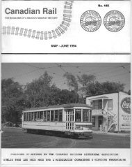
<strong>Canadian</strong> National and <strong>Canadian</strong> Pacific<br />
Lakeshore Commuter Service<br />
<strong>Canadian</strong> National <strong>Rail</strong>ways<br />
The oldest of all commuter services in the<br />
Montreal area was the Montreal and Lachine <strong>Rail</strong> Road<br />
(M & L) constructed in 1847 between, what was then, the<br />
western outskirts of Montreal at Chaboillez Square and a<br />
wharf situated near, what is now, 20th Avenue, Lachine, a<br />
distance of just under eight miles. The Montreal terminus<br />
was at Bonaventure station, just east of the present<br />
intersection of Peel and St. Jacques Streets. At that time<br />
St. Jacques Street was called St. Bonaventure Street, from<br />
which the station derived its name. The purpose of the<br />
railway was to provide a portage route allowing<br />
passengers to avoid the slow steamer trip through the<br />
Lachine canal (which bypassed the Lachine rapids).<br />
Although Lachine was far removed from<br />
the commercial centre of Montreal, there were a certain<br />
number of passengers who could take the train to town for<br />
the day. It was not surprising, therefore, that intermediate<br />
stations began to appear for the convenience of the<br />
public. For example, as early as 1851 the<br />
American <strong>Rail</strong>way Guide shows a station at<br />
Tanneries, later renamed Tanneries Junction, and then<br />
Saint Henri.<br />
The year 1850 saw the amalgamation of the<br />
M & L with the Lake St. Louis and Province Line <strong>Rail</strong>way<br />
which ran from Caughnawaga, a community on the south<br />
shore of the St. Lawrence river opposite Lachine, to<br />
Plattsburgh, New York. This merger resulted in a change<br />
of name to the Montreal and New York <strong>Rail</strong>road. A<br />
further amalgamation took place in 1857, this time of the<br />
Montreal and New York <strong>Rail</strong>road and the Champlain and<br />
St. Lawrence <strong>Rail</strong>-Road, the combined company taking<br />
the name Montreal and Champlain (M & C).<br />
Meanwhile in 1855 the Grand Trunk<br />
<strong>Rail</strong>way of Canada (GTR) built westward from Montreal<br />
to Brockville, Ontario as part of their through trunk line<br />
to Toronto. Its Montreal terminal was at Point St. Charles.<br />
At that time the GTR system was built to the "provincial"<br />
gauge of 66 inches. As this railway was constructed,<br />
stations were established to serve important communities<br />
on the west end of the island of Montreal, such as Pointe<br />
Claire and Ste. Anne de Bellevue as well as those off the<br />
island such as Vaudreuil and Cedars.<br />
Operation from Point St. Charles was<br />
inconvenient due to its location relative to the<br />
commercial area and a remedy was found when, in 1864,<br />
the GTR leased the M & C. As the M & C was built to the<br />
standard gauge of 56 1/2 inches, the GTR gained access to<br />
Bonaventure street station by laying a third rail from<br />
Tanneries Jct. (St. Henri) to Bonaventure station. The use<br />
of this facility by the GTR was made permanent when, in<br />
1872, it acquired ownership of the M & C.<br />
The M & C continued to serve communities<br />
Service de trains de banlieue dans le corridor<br />
Lakeshore<br />
<strong>Le</strong> Canadien National<br />
La plus ancienne ligne de chemin de fer à<br />
desservir la banlieue est celle de la Montreal and Lachine<br />
<strong>Rail</strong>road (M&L), construite en 1847 entre la limite ouest<br />
de la ville – soit le square Chaboillez et un quai tout<br />
proche – et l’actuelle 20e Avenue, à Lachine, une distance<br />
d’à peine 13 km. <strong>Le</strong> terminus se trouve à la gare<br />
Bonaventure, à l’est de la présente intersection des rues<br />
Saint-Jacques et Peel. À cette époque, la rue Saint-<br />
Jacques s’appelle rue Saint-Bonaventure, d’où le nom de<br />
la gare. Cette ligne vise à permettre aux voyageurs de<br />
contourner les rapides de Lachine sans avoir à emprunter<br />
le canal en navire à vapeur, ce qui prend beaucoup de<br />
temps.<br />
Même si Lachine se trouve loin du centre<br />
des affaires de Montréal, un certain nombre de passagers<br />
prennent le train pour se rendre en ville. Il n’est donc pas<br />
surprenant de voir des gares intermédiaires s’implanter<br />
pour répondre aux besoins du public. Ainsi, dès 1851, le<br />
magazine American <strong>Rail</strong>way Guide indique une gare à<br />
Tanneries, qui sera rebaptisée plus tard Tanneries<br />
Jonction, puis Saint-Henri.<br />
L’année 1850 voit la M&L fusionner avec la<br />
Lake St. Louis and Province Line <strong>Rail</strong>way, qui relie<br />
Caughnawaga, communauté de la rive sud du Saint-<br />
Laurent située en face de Lachine, à Plattsburgh, dans<br />
l’État de New York. Elle prend alors le nom de Montreal<br />
and New York <strong>Rail</strong>road. En 1857, elle fusionne à nouveau<br />
avec la Champlain and St. Lawrence <strong>Rail</strong>-Road et devient<br />
la Montreal and Champlain <strong>Rail</strong>road (M&C).<br />
Entretemps, en 1855, la Compagnie de<br />
chemin de fer du Grand Tronc du Canada (GTR)<br />
construit le tronçon Montréal-Brockville dans le cadre de<br />
son projet de ligne directe vers Toronto. Son terminus à<br />
Montréal est Pointe-Saint-Charles. À cette époque,<br />
l’écartement des rails du GTR est de 66 po, le standard<br />
provincial. À mesure que la voie ferrée progresse, des<br />
gares voient le jour pour desservir les principales localités<br />
de l’Ouest-de-l’Île, notamment Pointe-Claire et Sainte-<br />
Anne-de-Bellevue, ainsi que celles de l’autre rive, comme<br />
Vaudreuil et <strong>Le</strong>s Cèdres.<br />
La gare de Pointe-Saint-Charles avait un<br />
inconvénient : elle était trop éloignée de la zone<br />
commerciale. La solution se présente quand, en 1864, le<br />
GT prend à bail le M&C, dont l’écartement standard est<br />
de 56 1/2 po. <strong>Le</strong> GT peut désormais rejoindre le centreville<br />
en construisant une troisième voie de Tanneries<br />
Jonction (Saint-Henri) à la gare de la rue Bonaventure.<br />
En 1872, le GT rachètera le M&C, ce qui lui permettra<br />
d’utiliser ce tronçon à sa guise.<br />
<strong>Le</strong> M&C continue de desservir les localités<br />
qui bordent la voie ferrée menant à Lachine et dont le<br />
terminus est toujours le quai de Lachine. Vers les années