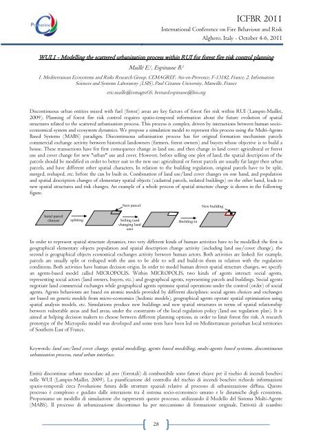
ICFBR 2011International Conference on Fire Behaviour and RiskAlghero, Italy - October 4-6, 2011WUI.1 - Modelling the scattered urbanization process within RUI for forest fire risk control planningMaillé E. 1 , Espinasse B. 21. Me<strong>di</strong>terranean Ecosystems and Risks Research Group, CEMAGREF, Aix-en-Provence, F-13182, France; 2. InformationSciences and Systems Laboratory (LSIS), Paul Cézanne University, Marseille, Franceeric.maille@cemagref.fr, bernard.espinasse@lsis.orgDiscontinuous urban entities mixed with fuel (forest) areas are key factors of forest fire risk within RUI (Lampin-Maillet,2009). Planning of forest fire risk control requires spatio-temporal information about the future evolution of spatialstructures related to the scattered urbanisation process. This process is complex, driven by interactions between human socioeconomicalsystem and ecosystem dynamics. We propose a simulation model to represent this process using the Multi-AgentsBased Systems (MABS) para<strong>di</strong>gm. Discontinuous urbanisation process has for original formation mechanism parcelscommercial exchange activity between historical landowners (farmers, forest owners) and buyers whose objective is to build ahouse. These transactions have for first consequence change in land use, and then change in land cover: agricultural or forestuse and cover change for new "urban" use and cover. However, before selling one plot of land, the spatial description of theparcels should be mo<strong>di</strong>fied in order to better suit to the new use: agricultural or forest parcels are usually far larger then urbanparcels, and have <strong>di</strong>fferent other spatial characters. In relation to the buil<strong>di</strong>ng regulation, original parcels have to be split,merged, reshaped, etc. before the can be built in. Combination of land use/land cover changes on one hand, and populationand spatial description changes of elementary spatial objects (cadastral parcels, isolated buil<strong>di</strong>ngs) on the other hand, leads tonew spatial structures and risk changes. An example of a whole process of spatial structure change is shown in the followingfigure.New parcelNew buil<strong>di</strong>ngInital parcel(forest)splittingSelling (andchanging landuse)Buil<strong>di</strong>ng-inIn order to represent spatial structure dynamics, two very <strong>di</strong>fferent kinds of human activities have to be modelled: the first isgeographical elementary objects population and spatial description change activity (inclu<strong>di</strong>ng land use/cover change), thesecond is geographical objects economical exchanges activity between human actors. Both activities are linked: for example,parcels are usually split or reshaped with the aim to be able to sell and build-in them in relation with the regulationcon<strong>di</strong>tions. Both activities have human decision origin. In order to model human driven spatial structure changes, we specifyan agents-based model called MICROPOLIS. Within MICROPOLIS, two kinds of agents interact: social agents,representing social actors (land owners, buyers, etc.) and geographical agents, representing parcels and buil<strong>di</strong>ngs. Social agentsnegotiate land commercial exchanges while geographical agents optimise spatial operations under the control (order) of socialagents. Agents behaviours are based on atomic models provided by <strong>di</strong>fferent <strong>di</strong>sciplines: social agents choices and exchangesare based on generic models from micro-economics (hedonic models), geographical agents operate spatial optimisation usingspatial analysis models, etc. Simulations produce new buil<strong>di</strong>ngs and new spatial structures in terms of spatial relationshipbetween vulnerable areas and fuel areas, under the constraints of the local regulation policy (land use regulation plan). It isaimed at helping decision makers to choose between <strong>di</strong>fferent planning options, in order to limit forest fire risk. A researchprototype of the Micropolis model was developed and some tests have been led on Me<strong>di</strong>terranean periurban local territoriesof Southern East of France.Keywords: land use/land cover change, spatial modelling, agents based modelling, multi-agents based systems, <strong>di</strong>scontinuousurbanisation process, rural urban interface.Entità <strong>di</strong>scontinue urbane mescolate ad aree (forestali) <strong>di</strong> combustibile sono fattori chiave per il rischio <strong>di</strong> incen<strong>di</strong> boschivinelle WUI (Lampin-Maillet, 2009). La pianificazione del controllo del rischio <strong>di</strong> incen<strong>di</strong> boschivi richiede informazionispazio-temporali circa l'evoluzione futura delle strutture spaziali relative al processo <strong>di</strong> urbanizzazione <strong>di</strong>ffusa. Questoprocesso è complesso e guidato dalle interazioni tra il sistema socio-economico umano e le <strong>di</strong>namiche <strong>degli</strong> ecosistemi.Proponiamo un modello <strong>di</strong> simulazione che rappresenti questo processo, utilizzando il Modello del Sistema Multi-Agente(MABS). Il processo <strong>di</strong> urbanizzazione <strong>di</strong>scontinuo ha per meccanismo <strong>di</strong> formazione originale, l'attività <strong>di</strong> scambio28
ICFBR 2011International Conference on Fire Behaviour and RiskAlghero, Italy - October 4-6, 2011commerciale <strong>di</strong> lotti tra proprietari terrieri storici (agricoltori, proprietari <strong>di</strong> foreste) e acquirenti il cui obiettivo è <strong>di</strong>costruire una casa. Tali transazioni hanno come prima conseguenza il cambiamento <strong>di</strong> destinazione d'uso dei terreni,e poi la mo<strong>di</strong>fica della copertura del suolo: uso agricolo o forestale, cambiamento della copertura per il nuovo uso ela nuova copertura <strong>di</strong> tipo ―urbano‖. Tuttavia, prima <strong>di</strong> vendere un appezzamento <strong>di</strong> terreno, la descrizione spazialedei lotti dovrebbe essere mo<strong>di</strong>ficata per meglio adattarsi al nuovo utilizzo: i lotti agricoli o forestali sono in generemolto più gran<strong>di</strong> <strong>di</strong> quelli urbani, e hanno <strong>di</strong>verse caratteristiche spaziali. In relazione al regolamento e<strong>di</strong>lizio, i lottioriginali devono essere <strong>di</strong>visi, uniti, riorganizzati, ecc. prima che vi si possa costruire. Una combinazione <strong>di</strong>cambiamento nell'utilizzo del territorio/copertura del suolo da una parte, e cambiamenti nella popolazione edescrizione spaziale <strong>di</strong> oggetti spaziali elementari (lotti catastali, e<strong>di</strong>fici isolati) dall'altra, portano a nuove strutturespaziali e mo<strong>di</strong>fiche dei rischi. Nella figura seguente si può osservare l‘esempio <strong>di</strong> un intero processo <strong>di</strong> cambiamentodella struttura spaziale. Al fine <strong>di</strong> rappresentare la <strong>di</strong>namica della struttura spaziale, devono essere descritti con unmodello due tipi molto <strong>di</strong>versi <strong>di</strong> attività umane: la prima è l'attività <strong>di</strong> cambiamento nella popolazione e descrizionespaziale <strong>di</strong> oggetti elementari geografici (compresi cambiamenti nell'utilizzo/copertura del suolo), la seconda èl'attività <strong>di</strong> scambio economico <strong>di</strong> oggetti geografici tra attori umani. Entrambe le attività sono collegate: peresempio, i lotti <strong>di</strong> solito sono <strong>di</strong>visi o riorganizzati con l'obiettivo <strong>di</strong> poter essere venduti e costruiti in relazione allecon<strong>di</strong>zioni del regolamento. Entrambe le attività <strong>di</strong>pendono dalle decisioni umane. Al fine <strong>di</strong> modellare icambiamenti delle strutture spaziali determinati dall'uomo, abbiamo creato un modello basato su agenti chiamatoMICROPOLIS. All'interno <strong>di</strong> MICROPOLIS, interagiscono tra loro due tipi <strong>di</strong> agenti: gli agenti sociali, cherappresentano gli attori sociali (proprietari terrieri, acquirenti, ecc.) e gli agenti geografici, che rappresentano i lotti egli e<strong>di</strong>fici. Gli agenti sociali negoziano gli scambi commerciali terrieri mentre gli agenti geografici ottimizzano leoperazioni spaziali sotto il controllo (or<strong>di</strong>ne) <strong>degli</strong> agenti sociali. I comportamenti <strong>degli</strong> agenti sono basati su modelliatomici forniti da <strong>di</strong>scipline <strong>di</strong>verse: le scelte e gli scambi <strong>degli</strong> agenti sociali si basano su modelli generici dellamicro-economia (modelli edonistici); gli agenti geografici operano un'ottimizzazione dello spazio utilizzando modelli<strong>di</strong> analisi spaziale, ecc. Le simulazioni producono nuovi e<strong>di</strong>fici e nuove strutture spaziali in termini <strong>di</strong> rapportospaziale tra aree vulnerabili e aree <strong>di</strong> combustibile, sotto i vincoli della politica dei regolamenti locali (pianoregolatore sulla destinazione d'uso dei terreni), con lo scopo <strong>di</strong> aiutare i decisori a scegliere tra <strong>di</strong>verse opzioni <strong>di</strong>pianificazione, al fine <strong>di</strong> limitare il rischio <strong>di</strong> incen<strong>di</strong> boschivi. È stato sviluppato un prototipo <strong>di</strong> ricerca del modelloMicropolis e sono stati condotti alcuni test sui territori locali peri-urbani me<strong>di</strong>terranei della Francia sud-orientale.Les entités urbaines <strong>di</strong>scontinues mêlées aux zones combustibles (forêt) constituent des facteurs clés du risque de feude forêt dans l'interface rural-urbain (RUI; Lampin-Maillet, 2009). La planification du contrôle du risque d‘incen<strong>di</strong>enécessite des informations spatiales et temporelles sur l‘évolution future des structures spatiales liées au processusd‘urbanisation <strong>di</strong>scontinu. Ce processus est complexe, déterminé par les interactions entre le système socioéconomiquehumain et la dynamique de l‘écosystème. Nous proposons un modèle de simulation pour représenter ceprocessus en utilisant le para<strong>di</strong>gme des systèmes multiagents (MABS). Le processus d‘urbanisation <strong>di</strong>scontinue a pourorigine l‘activité d‘échanges commerciaux des parcelles entre les propriétaires terriens historiques (agriculteurs,propriétaires forestiers) et les acheteurs dont l‘objectif est la construction d‘un logement. Ces transactions ont pourconséquence première le changement d‘utilisation du sol, et dans un deuxième temps le changement d‘occupation dusol: d'une utilisation agricole ou forestière, les parcelles acquièrent leur nouvelle utilisation et occupation «urbaines».Cependant, avant la vente d'un lot de terre, la description spatiale des parcelles doit être mo<strong>di</strong>fiée pour mieuxs‘adapter à la nouvelle utilisation : les parcelles agricoles ou forestières sont généralement plus grandes que lesparcelles urbaines et ont des caractéristiques spatiales <strong>di</strong>fférentes. Pour s'adapter au règlement d'urbanisme, lesparcelles originales doivent être morcelées, fusionnées, déformées, etc. avant la construction. La combinaison deschangements dans l‘utilisation/occupation du sol d‘une part, et dans la population et la description spatiale des objetsspatiaux élémentaires (parcelles cadastrales, immeubles isolés) d‘autre part, entraîne de nouvelles structures spatiales etde nouveaux changements du risque. Un exemple d‘un processus global de changement de structure spatiale estprésenté dans la figure suivante. Pour représenter la dynamique de la structure spatiale, deux types très <strong>di</strong>fférentsd‘activités humaines doivent être modélisés: le premier est la population des objets élémentaires géographiques etl‘activité de changement de la description spatiale (y compris le changement d‘utilisation/occupation du sol), ladeuxième est l‘activité d‘échange économique des objets géographiques entre les acteurs humains. Les deux activitéssont liées: par exemple, les parcelles sont généralement séparées ou déformées dans le but de pouvoir les vendre et lesconstruire conformément à la réglementation. Les deux activités ont pour origine une décision humaine. Pourmodéliser les changements des structures spatiales d'origine anthropique, nous avons mis sur pied un modèle baséagents, appelé MICROPOLIS. Deux types d‘agents interagissent dans MICROPOLIS: les agents sociauxreprésentant les acteurs sociaux (propriétaires terriens, acheteurs, etc.) et les agents géographiques, représentant lesSESSION 2: Fire Risk at WUI29