
You also want an ePaper? Increase the reach of your titles
YUMPU automatically turns print PDFs into web optimized ePapers that Google loves.
42<br />
TroLig boLig<br />
Kampagnen Rolig Bolig - Få råd<br />
til mindre vejstøj i almene boliger,<br />
sætter fokus på vejstøjens<br />
sundhedsskadelige konsekvenser<br />
og giver gode råd til, hvordan<br />
boligorganisationer kan dæmpe<br />
vejstøj. Bag kampagnen står <strong>Miljøministeriet</strong>,<br />
Landsbyggefonden<br />
og Socialministeriet. Formålet<br />
med kampagnen er at informere<br />
beboere og ledelse i almene<br />
boligafdelinger om vejstøjens<br />
konsekvenser for helbred og livskvalitet,<br />
og at der er fl ere gode<br />
metoder til at dæmpe støjen.<br />
Se kampagnen på www.roligbolig.dk<br />
MST <strong>2011</strong><br />
miLjønyT <strong>nr</strong>. 60<br />
I udgave nummer 60 af Miljøstyrelsens<br />
elektroniske nyhedsbrev<br />
kan man læse om gravide<br />
og hormonforstyrrende stoffer<br />
og om at gulvpuslespil på det<br />
danske marked ikke udgør nogen<br />
sundhedsrisiko for børn.<br />
www.miljonyt.dk<br />
Kort & Matrikelstyrelsen<br />
www.kms.dk<br />
Strategisk grundlag<br />
Kort & Matrikelstyrelsen <strong>2011</strong>-2015<br />
STEDET SOM INDGANG<br />
TIL DIGITAL FORVALTNING<br />
udgiVeLser fra miLjøminisTerieT<br />
sTedeT som indgang TiL<br />
digiTaL forVaLTning*<br />
Data skal kun indhentes én gang,<br />
de skal vedligeholdes, hvor det<br />
kan gøres mest effektivt, og de<br />
skal kunne anvendes bredt på<br />
tværs af forvaltningsniveauer og<br />
sektorer i den offentlige administration.<br />
Disse principper er helt centrale<br />
i Kort & Matrikelstyrelsens<br />
nye strategiske grundlag, Stedet<br />
som indgang til digital forvaltning,<br />
og de skal bidrage til at<br />
gøre den offentlige sektor mere<br />
sammenhængende, enkel og<br />
effektiv. Principperne underbygger<br />
i høj grad det fællesoffentlige<br />
samarbejde omkring digitalisering.<br />
Strategien er fx på linje med<br />
tankerne bag en række fællesoffentlige<br />
initiativer, såsom Danmarks<br />
Miljøportal og Statens It.<br />
KMS <strong>2011</strong><br />
http://www.kms.dk/NR/<br />
rdonlyres/47171A93-BB47-447C-<br />
A977-9D16652CA1C6/0/_Strategi_Final_web.pdf<br />
M i l j ø D a n M a r k n r . 2 a p r i l 2 0 1 1<br />
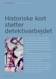
TECHNICAL REPORT NO. 09<br />
Change detection for semi-automatic<br />
map database updating<br />
Allan Aasbjerg Nielsen and Brian Pilemann Olsen<br />
Change deTeCTion for<br />
semi-auTomaTiC maP<br />
daTabase uPdaTing<br />
the problem dealt with in this report<br />
concerns automatic change<br />
detection: determination of<br />
changes in between two states.<br />
KMS conducts fl ight campaigns<br />
over a given geographical area<br />
approximately every third year<br />
(sometimes even more often).<br />
the outcome is nadir looking<br />
aerial photos and computed ortho<br />
photos. the photos are georeferenced<br />
by GPS, INS and aerial<br />
triangulation, and the images are<br />
used for 3D mapping. At time t0<br />
the map database, at this time<br />
FOt, is established. At time t0<br />
+Δt the map data base is to be revised,<br />
and a new fl ight campaign<br />
carried out. the revision process<br />
is carried out by 3D-superimposition<br />
of the existing map database<br />
onto the stereo models from the<br />
new fl ight campaign. Differences<br />
(changes) are manually detected<br />
and collected by a human stereo<br />
operator. this is a process step<br />
that is very time consuming and<br />
thus costly. Also it is not evident<br />
if all changes are detected by the<br />
human operator. For these reasons<br />
the development of an automatic<br />
change detection algorithm<br />
would be very profi table as map<br />
production costs could be reduced<br />
dramatically. If all changes<br />
changes are detected automatically<br />
the human stereo operator<br />
could automatically "‘jump"’ from<br />
one potential change to another<br />
only using time collecting the<br />
change and not wasting time<br />
searching for changes. this<br />
report presents a new method for<br />
automatic change detection. the<br />
algorithm is based on an iterated<br />
version of an established method<br />
in multivariate statistics, namely<br />
canonical correlation analysis.<br />
the algorithm has been applied<br />
to a representative Danish suburban<br />
test area of 1x1 km2 and the<br />
outcome of this investigation is<br />
presented.<br />
technical report no. 9<br />
KMS 2010<br />
ftp://ftp.kms.dk/download/<br />
technical_Reports/KMS_technical_Report_9.pdf<br />
TECHNICAL REPORT NO. 10<br />
Horizontal Accuracy of Digital<br />
Elevation Models<br />
M. Nour Hawa Thomas Knudsen Simon L. Kokkendorff Brian P. Olsen Brigitte C. Rosenkranz<br />
horiZonTaL aCCuraCy of<br />
digiTaL eLeVaTion modeLs<br />
Quality control procedures for<br />
digital elevation models are often<br />
focused on checking the validity<br />
of the raw measurements behind<br />
the fi nal gridded model. And<br />
rightfully so since, as the adage<br />
goes, “garbage in, garbage out”:<br />
without good measurements it is<br />
impossible to obtain a good fi nal<br />
model.<br />
But for the end user of the<br />
gridded model, the validity and<br />
accuracy of the model per se is<br />
much more interesting. And while<br />
the vertical accuracy of the fi nal<br />
model can be checked in a fairly<br />
straightforward manner (by comparing<br />
independently surveyed<br />
point heights with height values<br />
obtained by interpolation in the<br />
grid), the same is not true with<br />
respect to the horizontal accuracy:<br />
the horizontal accuracy relates<br />
to the true position of objects<br />
in the landscape – objects which<br />
may even be hard to resolve due<br />
to the limited grid cell size. For<br />
DK-DEM, the new Danish national<br />
elevation model, we have a stated<br />
goal of a horizontal accuracy on<br />
the order of 1 m – but a grid cell<br />
size of 1.6 m. It should be evident<br />
that while we have all reasons to<br />
believe that the desired accuracy<br />
has been reached for the LiDAR<br />
point cloud behind DK-DEM, it<br />
is an entirely different and much<br />
more complex, story to ensure<br />
that the accuracy has been carried<br />
all the way through to the<br />
grid. the following papers tell<br />
that “much more complex story”:<br />
First an executive summary,<br />
confi rming that the accuracy goal<br />
has been reached. the summary<br />
is followed by a paper describing<br />
in which sense we defi ne horizontal<br />
accuracy. the third paper describes<br />
how the actual tests were<br />
carried out, and is followed by 4<br />
lab reports describing the results<br />
from each of 4 test sites. DK-DEM<br />
is a large and complex dataset,<br />
so by its very nature it will have<br />
occasional errors. the present<br />
report does, however, support the<br />
assertion that the overall quality<br />
of DK-DEM is very high.<br />
technical report no. 10<br />
KMS 2010<br />
ftp://ftp.kms.dk/download/<br />
technical_Reports/KMS_technical_Report_10.pdf<br />
akTueL informaTion<br />
om de danske haVne og<br />
broer<br />
På www.danskehavnelods.dk<br />
fi ndes informationer om danske<br />
erhvervs- og lystbådehavne samt<br />
om vej- og jernbanebroer i de<br />
danske farvande. Informationerne<br />
opdateres ugentlig.<br />
Søkort og nautiske publikationer<br />
distribueres af Iver C. Weilbach &<br />
Co. A/S:<br />
www.weilbach.dk<br />
Lovstof<br />
Lov om ændring af lov om et<br />
testcenter for store vindmøller<br />
ved Østerild<br />
(Ekspropriation af eksisterende<br />
produktionsvindmøller m.v.)<br />
Lov <strong>nr</strong>. 159 af 1. marts <strong>2011</strong><br />
Lov om ændring af lov om miljøgodkendelse<br />
m.v. af husdyrbrug<br />
(Ændring af reglerne om udledning<br />
af ammoniak og om beholdere<br />
til opbevaring af fl ydende<br />
husdyrgødning, inddragelse af<br />
offentligheden m.v.)<br />
Lov <strong>nr</strong>. 122 af 23. februar <strong>2011</strong><br />
Bekendtgørelse om anmeldelsesordningen<br />
efter naturbeskyttelseslovens<br />
§ 19 b og skovlovens<br />
§ 17<br />
Bkg. <strong>nr</strong>. 101 af 11. februar <strong>2011</strong><br />
Bekendtgørelse om beretninger<br />
om miljøtilsyn og miljøgodkendelser<br />
m.v.<br />
Bkg. <strong>nr</strong>. 99 af 11. februar <strong>2011</strong><br />
Bekendtgørelse om ophævelse<br />
af bekendtgørelse om erhvervsmæssigt<br />
dyrehold, husdyrgødning,<br />
ensilage m.v.<br />
Bkg. <strong>nr</strong>. 111 af 4. februar <strong>2011</strong><br />
Bekendtgørelse om organisationers<br />
frivillige deltagelse i en fællesskabsordning<br />
for miljøledelse<br />
og miljørevision (EMAS)<br />
Bkg. <strong>nr</strong>. 96 af 4. februar <strong>2011</strong><br />
Bekendtgørelse om klassifi cering<br />
og fastsættelse af mål for<br />
naturtilstanden i internationale<br />
naturbeskyttelsesområder<br />
Bkg. <strong>nr</strong>. 144 af 20. januar <strong>2011</strong><br />
Bekendtgørelse om udarbejdelse<br />
af økonomisk analyse til brug for<br />
vandplaner<br />
Bkg. <strong>nr</strong>. 39 af 19. januar <strong>2011</strong>