Mpumalanga Biodiversity Conservation Plan Handbook - bgis-sanbi
Mpumalanga Biodiversity Conservation Plan Handbook - bgis-sanbi
Mpumalanga Biodiversity Conservation Plan Handbook - bgis-sanbi

Create successful ePaper yourself
Turn your PDF publications into a flip-book with our unique Google optimized e-Paper software.
MPUMALANGA BIODIVERSITY CONSERVATION PLAN HANDBOOK<br />
28<br />
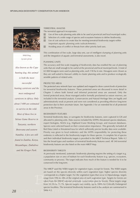
Wild Dog<br />
Lycaon pictus<br />
Also known as the Cape<br />
hunting dog, this animal<br />
is both the most<br />
successful<br />
hunting carnivore and the<br />
most endangered<br />
carnivore in Africa. Only<br />
about 5 600 are estimated<br />
to survive in the wild.<br />
Most of these live in<br />
Selous Game Reserve in<br />
Tanzania, northern<br />
Botswana and eastern<br />
Namibia. A few are still<br />
found in Zambia, Kenya,<br />
Mozambique, Zimbabwe<br />
and the Kruger Park.<br />
TERRESTRIAL ANALYSIS<br />
The terrestrial approach incorporates:<br />
Use of fine-scale planning units able to be used at provincial and local municipal scales;<br />
Selection of a wide range of species and ecosystem features to define biodiversity;<br />
Use of cost surfaces to create bias for meeting terrestrial biodiversity targets within<br />
important aquatic planning units (subcatchments);<br />
Avoiding areas of conflict or threats from other priority land uses.<br />
This combination of fine scale, large data sets, use of intelligent clumping of planning units<br />
and the integration of aquatic and terrestrial assessments, is also novel.<br />
PLANNING UNITS<br />
The accuracy and fine-scale mapping of biodiversity data has enabled the use of planning<br />
units that are small enough to be useful at the provincial and local municipal levels. A total of<br />
65 000 hexagons were used as planning units, each 118 ha in size. Hexagons were chosen as<br />
they are well suited to Marxan’s ability to cluster planning units and to produce ecologically<br />
sensible patterns of related units.<br />
PROTECTED AREAS<br />
The protected area network layer was updated and mapped to show current levels of protection<br />
for terrestrial biodiversity features. These protected areas are discussed in more detail in<br />
Chapter 5 where both formal and informal protected areas are assessed. Only the<br />
formal protected areas, those managed and/or formally proclaimed as nature reserves, are<br />
included in the terrestrial analysis. Conservancies and Natural Heritage Sites are legally and<br />
administratively weak at present and were not considered as providing effective long-term<br />
protection due to their uncertain future. See Appendix 3 for an extended list of all protected<br />
areas in the Province.<br />
BIODIVERSITY FEATURES<br />
Terrestrial biodiversity data, or surrogates for biodiversity features, were captured in GIS and<br />
allocated to planning units. Data sources included the MTPA’s threatened species databases,<br />
expert biologists, NGOs (e.g. Highland Crane Working Group), and museum databases.<br />
Species were selected based on their conservation importance. This generally included all<br />
Red Data Listed or threatened taxa for which sufficiently precise locality data were available.<br />
Priority was given to local endemics and the MTPA responsibility for protecting these<br />
endemics is reflected in the biodiversity targets for these species. A complete list of species<br />
and their individual biodiversity targets is provided in the MBCP Technical Report. Table 4.2<br />
lists the broad types and numbers of terrestrial biodiversity features used. All 340 terrestrial<br />
biodiversity features are also listed on the main MBCP Map.<br />
BIODIVERSITY TARGETS<br />
As previously mentioned, systematic biodiversity planning requires the setting of a target (e.g.<br />
a population size or area of habitat) for each biodiversity feature (e.g. species, ecosystem,<br />
community or process). The target indicates how much of the feature is needed for it to be<br />
conserved in the long term.<br />
The MBCP used the NSBA targets for vegetation types, except for forests. The NSBA targets<br />
M P U M A L A N G A<br />
are based on the species diversity within each vegetation type: higher species diversity<br />
<strong>Biodiversity</strong><br />
corresponds to a higher target. For the vegetation types that occur in <strong>Mpumalanga</strong>, targets<br />
range from 19% to 28% of the original area of each vegetation type. Targets for forests are<br />
taken from the DWAF national systematic conservation plan for forests. These targets range<br />
from 59.5% to 71.7%. Species targets vary widely, up to 100% for Critically Endangered<br />
species localities. The terrestrial biodiversity features used in the analysis are summarised in<br />
Table 4.2.<br />
CONSERVATION PLAN HANDBOOK