NEW - Ken Gilbert
NEW - Ken Gilbert
NEW - Ken Gilbert

You also want an ePaper? Increase the reach of your titles
YUMPU automatically turns print PDFs into web optimized ePapers that Google loves.
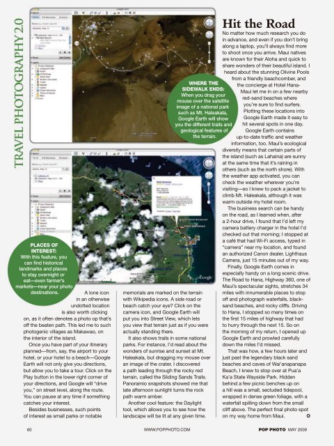
PLACES OF<br />
INTEREST:<br />
With this feature, you<br />
can fi nd historical<br />
landmarks and places<br />
to stay overnight or<br />
eat—even farmer’s<br />
markets—near your photo<br />
destinations.<br />
A lone icon<br />
in an otherwise<br />
undotted location<br />
is also worth clicking<br />
on, as it often denotes a photo op that’s<br />
off the beaten path. This led me to such<br />
photogenic villages as Makawao, on<br />
the interior of the island.<br />
Once you have part of your itinerary<br />
planned—from, say, the airport to your<br />
hotel, or your hotel to a beach—Google<br />
Earth will not only give you directions,<br />
but allow you to take a tour. Click on the<br />
Play button in the lower right corner of<br />
your directions, and Google will “drive<br />
you,” on street level, along the route.<br />
You can pause at any time if something<br />
catches your interest.<br />
Besides businesses, such points<br />
of interest as small parks or notable<br />
WHERE THE<br />
SIDEWALK ENDS:<br />
When you drag your<br />
mouse over the satellite<br />
image of a national park<br />
such as Mt. Haleakala,<br />
Google Earth will show<br />
you the different trails and<br />
geological features of<br />
the terrain.<br />
memorials are marked on the terrain<br />
with Wikipedia icons. A side road or<br />
beach catch your eye? Click on the<br />
camera icon, and Google Earth will<br />
put you into Street View, which lets<br />
you view that terrain just as if you were<br />
actually standing there.<br />
It also shows trails in some national<br />
parks. For instance, I’d read about the<br />
wonders of sunrise and sunset at Mt.<br />
Haleakala, but dragging my mouse over<br />
an image of the crater, I discovered<br />
a path leading through the rocky red<br />
terrain, called the Sliding Sands Trails.<br />
Panoramio snapshots showed me that<br />
late afternoon sunlight turns the rock<br />
path warm amber.<br />
Another cool feature: the Daylight<br />
tool, which allows you to see how the<br />
landscape will be lit at any given time.<br />
Hit the Road<br />
No matter how much research you do<br />
in advance, and even if you don’t bring<br />
along a laptop, you’ll always fi nd more<br />
to shoot once you arrive. Maui natives<br />
are known for their Aloha and quick to<br />
share wonders of their beautiful island. I<br />
heard about the stunning Olivine Pools<br />
from a friendly beachcomber, and<br />
the concierge at Hotel Hana-<br />
Maui let me in on a few nearby<br />
red-sand beaches where<br />
you’re sure to fi nd surfers.<br />
Plotting these locations into<br />
Google Earth made it easy to<br />
hit several spots in one day.<br />
Google Earth contains<br />
up-to-date traffi c and weather<br />
information, too. Maui’s ecological<br />
diversity means that certain parts of<br />
the island (such as Lahaina) are sunny<br />
at the same time that it’s raining in<br />
others (such as the north shore). With<br />
the weather app activated, you can<br />
check the weather wherever you’re<br />
visiting—so I knew to pack a jacket to<br />
climb Mt. Haleakala, although it was<br />
warm outside my hotel room.<br />
The business search can be handy<br />
on the road, as I learned when, after<br />
a 2-hour drive, I found that I’d left my<br />
camera battery charger in the hotel I’d<br />
checked out that morning; I stopped at<br />
a café that had Wi-Fi access, typed in<br />
“camera” near my location, and found<br />
an authorized Canon dealer, Lighthaus<br />
Camera, just 15 minutes out of my way.<br />
Finally, Google Earth comes in<br />
especially handy on a long scenic drive.<br />
The Road to Hana, Highway 360, one of<br />
Maui’s spectacular sights, stretches 34<br />
miles with innumerable places to stop<br />
off and photograph waterfalls, blacksand<br />
beaches, and rocky cliffs. Driving<br />
to Hana, I stopped so many times on<br />
the fi rst 15 miles of highway that had<br />
to hurry through the next 15. So on<br />
the morning of my return, I opened up<br />
Google Earth and prowled carefully<br />
down the miles I’d missed.<br />
That was how, a few hours later and<br />
just past the legendary black sand<br />
beaches and caves of Wai’anapanapa<br />
Beach, I knew to stop over at Pua’a<br />
Ka’a State Wayside Park. Hidden<br />
behind a few picnic benches up on<br />
a hill was a small, secluded tidepool,<br />
wrapped in dense green foliage, with a<br />
waterfall spilling down from the small<br />
cliff above. The perfect fi nal photo spot<br />
on my way home from Maui. p<br />
60 WWW.POPPHOTO.COM POP PHOTO MAY 2009