AIR MASSES AND FRONTS
AIR MASSES AND FRONTS
AIR MASSES AND FRONTS

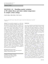
Create successful ePaper yourself
Turn your PDF publications into a flip-book with our unique Google optimized e-Paper software.
30 O<br />
30<br />
170 O<br />
O30 O<br />
160 O<br />
20 O<br />
150 O<br />
30 O<br />
130 O<br />
40 O<br />
40 O<br />
140 O<br />
30 O<br />
170 O<br />
180 O<br />
160 O<br />
150 O<br />
40 O<br />
130 O<br />
30 O<br />
140 O<br />
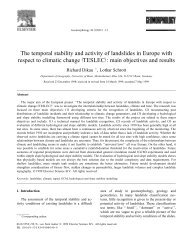
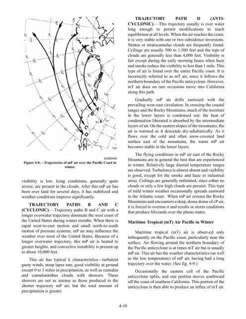
AG5f0408<br />
Figure 4-8.—Trajectories of mP air over the Pacific Coast in<br />
winter.<br />
visibility is low. Icing conditions, generally quite<br />
severe, are present in the clouds. After this mP air has<br />
been over land for several days, it has stabilized and<br />
weather conditions improve significantly.<br />
TRAJECTORY PATHS B <strong>AND</strong> C<br />
(CYCLONIC).—Trajectory paths B and C air with a<br />
longer overwater trajectory dominate the west coast of<br />
the United States during winter months. When there is<br />
rapid west-to-east motion and small north-to-south<br />
motion of pressure systems, mP air may influence the<br />
weather over most of the United States. Because of a<br />
longer overwater trajectory, this mP air is heated to<br />
greater heights, and convective instability is present up<br />
to about 10,000 feet.<br />
This air has typical k characteristics—turbulent<br />
gusty winds, steep lapse rate, good visibility at ground<br />
except 0 to 3 miles in precipitation, as well as cumulus<br />
and cumulonimbus clouds with showers. These<br />
showers are not as intense as those produced in the<br />
shorter trajectory mP air, but the total amount of<br />
precipitation is greater.<br />
50 O<br />
50 O<br />
40 O<br />
50 O<br />
170 O<br />
180 O<br />
160 O<br />
120 O<br />
150 O<br />
50 O<br />
130 O<br />
40 O<br />
C<br />
D<br />
140 O<br />
50 O<br />
30 O<br />
60 O<br />
A<br />
B<br />
60 O<br />
130 O 120 O<br />
120 O<br />
110<br />
40 O<br />
110 O<br />
O100 O<br />
4-10<br />
TRAJECTORY PATH D (ANTI-<br />
CYCLONIC).—This trajectory usually is over water<br />
long enough to permit modifications to reach<br />
equilibrium at all levels. When the air reaches the coast,<br />
it is very stable with one or two subsidence inversions.<br />
Stratus or stratocumulus clouds are frequently found.<br />
Ceilings are usually 500 to 1,500 feet and the tops of<br />
clouds are generally less than 4,000 feet. Visibility is<br />
fair except during the early morning hours when haze<br />
and smoke reduce the visibility to less than 1 mile. This<br />
type of air is found over the entire Pacific coast. It is<br />
incorrectly referred to as mT air, since it follows the<br />
northern boundary of the Pacific anticyclone. However,<br />
mT air does on rare occasions move into California<br />
along this path.<br />
Gradually mP air drifts eastward with the<br />
prevailing west-east circulation. In crossing the coastal<br />
ranges and the Rocky Mountains, much of the moisture<br />
in the lower layers is condensed out; the heat of<br />
condensation liberated is absorbed by the intermediate<br />
layers of air. On the eastern slopes of the mountains, the<br />
air is warmed as it descends dry-adiabatically. As it<br />
flows over the cold and often snow-covered land<br />
surface east of the mountains, the warm mP air<br />
becomes stable in the lower layers.<br />
The flying conditions in mP air east of the Rocky<br />
Mountains are in general the best that are experienced<br />
in winter. Relatively large diurnal temperature ranges<br />
are observed. Turbulence is almost absent and visibility<br />
is good, except for the smoke and haze in industrial<br />
areas. Ceilings are generally unlimited, since either no<br />
clouds or only a few high clouds are present. This type<br />
of mild winter weather occasionally spreads eastward<br />
to the Atlantic coast. When mP air crosses the Rocky<br />
Mountains and encounters a deep, dense dome of cP air,<br />
it is forced to overrun it and results in storm conditions<br />
that produce blizzards over the plains states.<br />
Maritime Tropical (mT) Air Pacific in Winter<br />
Maritime tropical (mT) air is observed only<br />
infrequently on the Pacific coast, particularly near the<br />
surface. Air flowing around the northern boundary of<br />
the Pacific anticyclone is at times mT air but is usually<br />
mP air. This air has the weather characteristics (as well<br />
as the low temperature) of mP air, having had a long<br />
trajectory over the water. (See fig. 4-9.)<br />
Occasionally the eastern cell of the Pacific<br />
anticyclone splits, and one portion moves southward<br />
off the coast of southern California. This portion of the<br />
anticyclone is then able to produce an influx of mT air.