AIR MASSES AND FRONTS
AIR MASSES AND FRONTS
AIR MASSES AND FRONTS

Create successful ePaper yourself
Turn your PDF publications into a flip-book with our unique Google optimized e-Paper software.
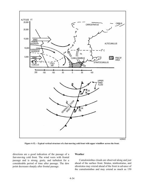
ALTITUDE FT<br />
25,000<br />
20,000<br />
15,000<br />
10,000<br />
5,000<br />
WIND<br />
FRONTAL<br />
INVERSION<br />
SUBSIDENCE<br />
INVERSION<br />
WIND<br />
CUMULUS<br />
0 O<br />
COLD<br />
<strong>AIR</strong><br />
200 150 100 50 0 50 100<br />
directions are a good indication of the passage of a<br />
fast-moving cold front. The wind veers with frontal<br />
passage and is strong, gusty, and turbulent for a<br />
considerable period of time after passage. The dew<br />
point decreases sharply after frontal passage.<br />
GENERALLY CLEAR<br />
SKIES<br />
CUMULONIMBUS<br />
4-34<br />
Ns<br />
Weather<br />
CIRROSTRATUS<br />
O<br />
0 C<br />
STRATOCUMULUS<br />
UPPER<br />
WIND-<br />
FLOW<br />
ALTOCUMULUS<br />
CIRRUS<br />
PRECIP.<br />
AREA<br />
Figure 4-32.—Typical vertical structure of a fast-moving cold front with upper windflow across the front.<br />
OR<br />
OR<br />
AG5f0432<br />
Cumulonimbus clouds are observed along and just<br />
ahead of the surface front. Stratus, nimbostratus, and<br />
altostratus may extend ahead of the front in advance of<br />
the cumulonimbus and may extend as much as 150