AIR MASSES AND FRONTS
AIR MASSES AND FRONTS
AIR MASSES AND FRONTS

Create successful ePaper yourself
Turn your PDF publications into a flip-book with our unique Google optimized e-Paper software.
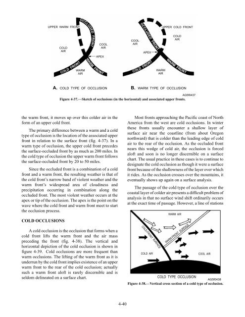
UPPER WARM FRONT<br />
COLD<br />
<strong>AIR</strong><br />
the warm front, it moves up over this colder air in the<br />
form of an upper cold front.<br />
The primary difference between a warm and a cold<br />
type of occlusion is the location of the associated upper<br />
front in relation to the surface front (fig. 4-37). In a<br />
warm type of occlusion, the upper cold front precedes<br />
the surface-occluded front by as much as 200 miles. In<br />
the cold type of occlusion the upper warm front follows<br />
the surface-occluded front by 20 to 50 miles.<br />
Since the occluded front is a combination of a cold<br />
front and a warm front, the resulting weather is that of<br />
the cold front’s narrow band of violent weather and the<br />
warm front’s widespread area of cloudiness and<br />
precipitation occurring in combination along the<br />
occluded front. The most violent weather occurs at the<br />
apex or tip of the occlusion. The apex is the point on the<br />
wave where the cold front and warm front meet to start<br />
the occlusion process.<br />
COLD OCCLUSIONS<br />
COLD FRONT<br />
OCCLUDED FRONT WARM FRONT<br />
WARM<br />
<strong>AIR</strong><br />
COOL<br />
<strong>AIR</strong><br />
APEX<br />
A cold occlusion is the occlusion that forms when a<br />
cold front lifts the warm front and the air mass<br />
preceding the front (fig. 4-38). The vertical and<br />
horizontal depiction of the cold occlusion is shown in<br />
figure 4-39. Cold occlusions are more frequent than<br />
warm occlusions. The lifting of the warm front as it is<br />
underrun by the cold front implies existence of an upper<br />
warm front to the rear of the cold occlusion; actually<br />
such a warm front aloft is rarely discernible and is<br />
seldom delineated on a surface chart.<br />
4-40<br />
COOL<br />
<strong>AIR</strong><br />
O<br />
C<br />
C R<br />
L F<br />
COLD FRONT<br />
UDED T WARM FRONT<br />
APEX<br />
O<br />
N<br />
WARM<br />
<strong>AIR</strong><br />
UPPER COLD FRONT<br />
COLD<br />
<strong>AIR</strong><br />
A. COLD TYPE OF OCCLUSION B. WARM TYPE OF OCCLUSION<br />
AG5f0437<br />
Figure 4-37.—Sketch of occlusions (in the horizontal) and associated upper fronts.<br />
Most fronts approaching the Pacific coast of North<br />
America from the west are cold occlusions. In winter<br />
these fronts usually encounter a shallow layer of<br />
surface air near the coastline (from about Oregon<br />
northward) that is colder than the leading edge of cold<br />
air to the rear of the occlusion. As the occluded front<br />
nears this wedge of cold air, the occlusion is forced<br />
aloft and soon is no longer discernible on a surface<br />
chart. The usual practice in these cases is to continue to<br />
designate the cold occlusion as though it were a surface<br />
front because of the shallowness of the layer over which<br />
it rides. As the occlusion crosses over the mountains, it<br />
eventually shows up again on a surface analysis.<br />
The passage of the cold type of occlusion over the<br />
coastal layer of colder air presents a difficult problem of<br />
analysis in that no surface wind shift ordinarily occurs<br />
at the exact time of passage. However, a line of stations<br />
COLD-FRONT SURFACE<br />
WARM <strong>AIR</strong><br />
WARM-FRONT SURFACE<br />
COLD <strong>AIR</strong> COOL <strong>AIR</strong><br />
COLD TYPE OCCLUSION<br />
AG5f0438<br />
Figure 4-38.—Vertical cross section of a cold type of occlusion.