AIR MASSES AND FRONTS
AIR MASSES AND FRONTS
AIR MASSES AND FRONTS

Create successful ePaper yourself
Turn your PDF publications into a flip-book with our unique Google optimized e-Paper software.
30 O<br />
100 O<br />
40 O<br />
100 O<br />
mT<br />
20 O<br />
40 O<br />
90 O<br />
mT<br />
AG5f0411<br />
Figure 4-11.—Trajectories of mT air over the Atlantic in<br />
winter.<br />
and Gulf of Mexico (fig. 4-11), mild temperatures, high<br />
humidities, and cloudiness are found, especially during<br />
the night and early morning. This is the characteristic<br />
weather found in mT air in the absence of frontal<br />
conditions. The stratus and stratocumulus clouds that<br />
form at night tend to dissipate during the middle of the<br />
day and fair weather prevails. Visibility is generally<br />
poor when the cloudiness is present; however, it<br />
improves rapidly because of convective activity when<br />
the stratus clouds dissipate. The ceilings associated<br />
with the stratus condition generally range from 500 to<br />
1,500 feet, and the tops are usually not higher than<br />
3,500 to 4,500 feet. Precipitation does not occur in the<br />
mT<br />
30O<br />
50 O<br />
40 O<br />
80 O<br />
80 O<br />
80<br />
50 O<br />
70 O<br />
30 O<br />
70 O<br />
40 O<br />
O70 O<br />
<strong>AND</strong> FOG<br />
GULF OF MEXICODRIZZLE O<br />
WATER TEMP. 20 C.<br />
20 O<br />
CUMULONIMBUS<br />
STRATUS<br />
4-12<br />
absence of frontal action. With frontal activity, the<br />
convective instability inherent in this air is released,<br />
producing copious precipitation.<br />
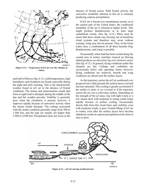
If mT air is forced over mountainous terrain, as in<br />
the eastern part of the United States, the conditional<br />
instability of the air is released at higher levels. This<br />
might produce thunderstorms or at least large<br />
cumuliform clouds. (See fig. 4-12.) Pilots must be<br />
aware that these clouds may develop out of stratiform<br />
cloud systems and therefore may occur without<br />
warning. Icing may also be present. Thus, in the Great<br />
Lakes area, a combination of all three hazards (fog,<br />
thunderstorms, and icing) is possible.<br />
Occasionally when land has been cooled along the<br />
coastal area in winter, maritime tropical air flowing<br />
inland produces an advection fog over extensive areas.<br />
(See fig. 4-13.) In general, flying conditions under this<br />
situation are fair. Ceilings and visibilities are<br />
occasionally below safe operating limits; however,<br />
flying conditions are relatively smooth and icing<br />
conditions are absent near the surface layers.<br />
As the trajectory carries the mT air northward over<br />
progressively colder ground, the surface layers cool and<br />
become saturated. This cooling is greatly accelerated if<br />
the surface is snow or ice covered or if the trajectory<br />
carries the air over a cold-water surface. Depending on<br />
the strength of the air mass, fog with light winds or a<br />
low stratus deck with moderate to strong winds forms<br />
rapidly because of surface cooling. Occasionally<br />
drizzle falls from this cloud form; and visibility, even<br />
with moderate winds, is poor. Frontal lifting of mT air<br />
in winter, even after the surface layers have become<br />
stabilized, results in copious precipitation in the form of<br />
rain or snow.<br />
O O<br />
10 C. SURFACE TEMP. 0 C.<br />
APPALACHIANS<br />
SW NE<br />
Figure 4-12.—mT air moving northeastward.<br />
AG5f0412