AIR MASSES AND FRONTS
AIR MASSES AND FRONTS
AIR MASSES AND FRONTS

You also want an ePaper? Increase the reach of your titles
YUMPU automatically turns print PDFs into web optimized ePapers that Google loves.
characterized by early-morning ground fogs or low<br />
stratus decks. Visibility is generally good except when<br />
haze or ground fog occurs near sunrise. Convective<br />
activity, usually observed during the daytime, ensures<br />
that no great amounts of smoke or dust accumulate in<br />
the surface layers. An exception to this is found under<br />
stagnant conditions near industrial areas, where<br />
restricted visibility may occur during the day and night.<br />
Pronounced surface diurnal temperature variations are<br />
observed in cP air during summer.<br />
The convective activity of this air is generally<br />
confined to the lower 7,000 to 10,000 feet. Flying<br />
conditions are generally smooth above approximately<br />
10,000 feet except when local showers develop.<br />
Showers, when observed, usually develop in a modified<br />
type of cPk over the southeastern part of the country.<br />
The base of cumulus clouds that form in this air is<br />
usually about 4,000 feet because of the relative dryness<br />
of this air mass.<br />
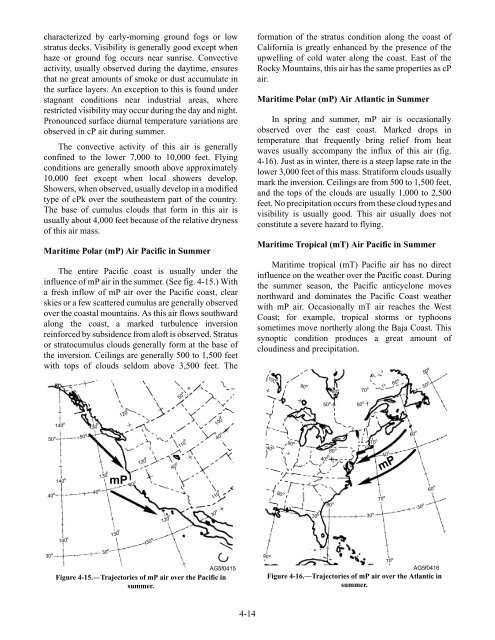
Maritime Polar (mP) Air Pacific in Summer<br />
The entire Pacific coast is usually under the<br />
influence of mP air in the summer. (See fig. 4-15.) With<br />
a fresh inflow of mP air over the Pacific coast, clear<br />
skies or a few scattered cumulus are generally observed<br />
over the coastal mountains. As this air flows southward<br />
along the coast, a marked turbulence inversion<br />
reinforced by subsidence from aloft is observed. Stratus<br />
or stratocumulus clouds generally form at the base of<br />
the inversion. Ceilings are generally 500 to 1,500 feet<br />
with tops of clouds seldom above 3,500 feet. The<br />
50<br />
140 O<br />
O 50O<br />
140 O<br />
130 O<br />
130<br />
O120 O<br />
mP<br />
40 O40O 40 O<br />
140 O<br />
130O<br />
120 O<br />
30 O30O 30 O<br />
AG5f0415<br />
Figure 4-15.—Trajectories of mP air over the Pacific in<br />
summer.<br />
120 O<br />
40 O<br />
50 O<br />
110 O<br />
100 O<br />
110 O<br />
30 O<br />
40 O<br />
4-14<br />
formation of the stratus condition along the coast of<br />
California is greatly enhanced by the presence of the<br />
upwelling of cold water along the coast. East of the<br />
Rocky Mountains, this air has the same properties as cP<br />
air.<br />
Maritime Polar (mP) Air Atlantic in Summer<br />
In spring and summer, mP air is occasionally<br />
observed over the east coast. Marked drops in<br />
temperature that frequently bring relief from heat<br />
waves usually accompany the influx of this air (fig.<br />
4-16). Just as in winter, there is a steep lapse rate in the<br />
lower 3,000 feet of this mass. Stratiform clouds usually<br />
mark the inversion. Ceilings are from 500 to 1,500 feet,<br />
and the tops of the clouds are usually 1,000 to 2,500<br />
feet. No precipitation occurs from these cloud types and<br />
visibility is usually good. This air usually does not<br />
constitute a severe hazard to flying.<br />
Maritime Tropical (mT) Air Pacific in Summer<br />
Maritime tropical (mT) Pacific air has no direct<br />
influence on the weather over the Pacific coast. During<br />
the summer season, the Pacific anticyclone moves<br />
northward and dominates the Pacific Coast weather<br />
with mP air. Occasionally mT air reaches the West<br />
Coast; for example, tropical storms or typhoons<br />
sometimes move northerly along the Baja Coast. This<br />
synoptic condition produces a great amount of<br />
cloudiness and precipitation.<br />
100 O<br />
40 O<br />
90 O<br />
90 O<br />
90 O<br />
90 O80O<br />
30 O<br />
50 O<br />
40 O<br />
80 O<br />
80<br />
mP<br />
AG5f0416<br />
Figure 4-16.—Trajectories of mP air over the Atlantic in<br />
summer.<br />
50 O<br />
70 O<br />
70 O<br />
70 O<br />
40 O<br />
60 O<br />
60 O<br />
O30 O<br />
30 O<br />
70 O<br />
50 O<br />
50 O<br />
60 O