AIR MASSES AND FRONTS
AIR MASSES AND FRONTS
AIR MASSES AND FRONTS

You also want an ePaper? Increase the reach of your titles
YUMPU automatically turns print PDFs into web optimized ePapers that Google loves.
unusual for two masses of different properties to be side<br />
by side without some movement, so the term stationary<br />
is a misnomer. Actually the front, or dividing line<br />
between the air masses, is most likely made up of small<br />
waves undulating back and forth; hence the term<br />
quasi-stationary. The important thing is that the front is<br />
not making any appreciable headway in any one<br />
direction. A front moving less than 5 knots is usually<br />
classified as a stationary front.<br />
CHARACTERISTICS<br />
When a front is stationary, the whole cold air mass<br />
does not move either toward or away from the front. In<br />
terms of wind direction, this means that the wind above<br />
the friction layer blows neither toward nor away from<br />
the front, but parallel to it. The wind shift across the<br />
front is usually near 180 degrees. It follows that the<br />
isobars, too, are nearly parallel to a stationary front.<br />
This characteristic makes it easy to recognize a<br />
stationary front on a weather map.<br />
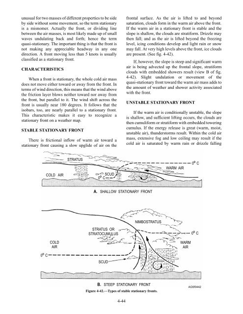
STABLE STATIONARY FRONT<br />
There is frictional inflow of warm air toward a<br />
stationary front causing a slow upglide of air on the<br />
O<br />
0 C<br />
COLD <strong>AIR</strong><br />
COLD<br />
<strong>AIR</strong><br />
STRATUS<br />
SCUD<br />
O<br />
0 C<br />
A. SHALLOW STATIONARY FRONT<br />
STRATUS OR<br />
STRATOCUMULUS<br />
SCUD<br />
4-44<br />
frontal surface. As the air is lifted to and beyond<br />
saturation, clouds form in the warm air above the front.<br />
If the warm air in a stationary front is stable and the<br />
slope is shallow, the clouds are stratiform. Drizzle may<br />
then fall; and as the air is lifted beyond the freezing<br />
level, icing conditions develop and light rain or snow<br />
may fall. At very high levels above the front, ice clouds<br />
are present. (See fig. 4-42).<br />
If, however, the slope is steep and significant warm<br />
air is being advected up the frontal slope, stratiform<br />
clouds with embedded showers result (view B of fig.<br />
4-42). Slight undulation or movement of the<br />
quasi-stationary front toward the warm air mass adds to<br />
the amount of weather and shower activity associated<br />
with the front.<br />
UNSTABLE STATIONARY FRONT<br />
If the warm air is conditionally unstable, the slope<br />
is shallow, and sufficient lifting occurs, the clouds are<br />
then cumuliform or stratiform with embedded towering<br />
cumulus. If the energy release is great (warm, moist,<br />
unstable air), thunderstorms result. Within the cold air<br />
mass, extensive fog and low ceiling may result if the<br />
cold air is saturated by warm rain or drizzle falling<br />
NIMBOSTRATUS<br />
B. STEEP STATIONARY FRONT<br />
Figure 4-42.—Types of stable stationary fronts.<br />
WARM <strong>AIR</strong><br />
WARM<br />
<strong>AIR</strong><br />
O<br />
0 C<br />
O<br />
0 C<br />
AG5f0442