AIR MASSES AND FRONTS
AIR MASSES AND FRONTS
AIR MASSES AND FRONTS

You also want an ePaper? Increase the reach of your titles
YUMPU automatically turns print PDFs into web optimized ePapers that Google loves.
fronts aloft can produce extensive cloud decks and<br />
blizzard conditions for several hundred miles over the<br />
mid western plains.<br />
INSTABILITY <strong>AND</strong> SQUALL LINES<br />
The terms instability line and squall line are<br />
synonymous with violent winds, heavy rain, lightning,<br />
thunder, hail, and tornadoes. The terms are often used<br />
interchangeably and are incorrectly applied to any<br />
severe weather phenomena that moves through a<br />
region. However, there is a difference between an<br />
instability line and a squall line.<br />
Instability Line<br />
An instability line is any nonfrontal line or band of<br />
convective activity. This is a general term and includes<br />
the developing, mature, and dissipating stages of the<br />
line of convective activity. However, when the mature<br />
stage consists of a line of active thunderstorms, it is<br />
properly termed a squall line. Therefore, in practice, the<br />
instability line often refers only to the less active<br />
phases.<br />
Squall Line<br />
A squall line is a nonfrontal line or band of active<br />
thunderstorms (with or without squalls). It is the<br />
mature, active stage of the instability line. From these<br />
definitions, instability and squall lines are air mass<br />
phenomenon because they are both nonfrontal<br />
occurrences. However, they are frequently associated<br />
with the fast-moving cold front.<br />
NOTE: The term instability line is the more<br />
general term and includes the squall line as a special<br />
case.<br />
Prefrontal Squall Lines<br />
A prefrontal squall line is a squall line located in<br />
the warm sector of a wave cyclone. They form about 50<br />
to 300 miles in advance of fast-moving cold fronts and<br />
are usually oriented roughly parallel to the cold front.<br />
They move in about the same direction as the cold front;<br />
however, their speed is, at times, faster than the cold<br />
front. You can roughly compute the direction and speed<br />
by using the winds at the 500-mb level. Squall lines<br />
generally move in the direction of the 500-mb wind<br />
flow and at approximately 40% of the wind speed.<br />
FORMATION.—There are several theories on the<br />
development of prefrontal squall lines. A generally<br />
4-36<br />
accepted theory is that as thunderstorms develop along<br />
the fast-moving front, large quantities of cold air from<br />
aloft descend in downdrafts along the front and form a<br />
wedge of cold air ahead of the front. The wedge of cold<br />
air then serves as a lifting mechanism for the warm,<br />
moist, unstable air; and a line of thunderstorms<br />
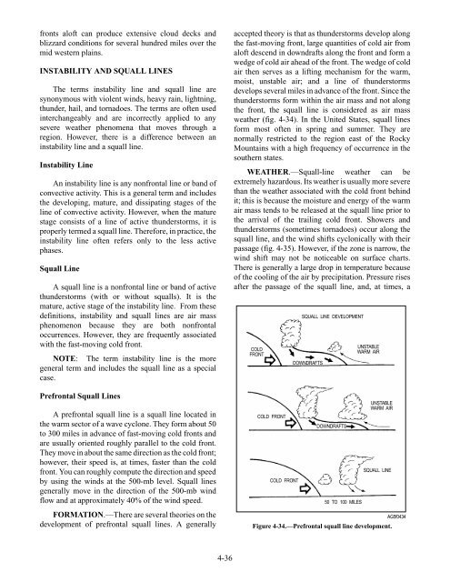
develops several miles in advance of the front. Since the<br />
thunderstorms form within the air mass and not along<br />
the front, the squall line is considered as air mass<br />
weather (fig. 4-34). In the United States, squall lines<br />
form most often in spring and summer. They are<br />
normally restricted to the region east of the Rocky<br />
Mountains with a high frequency of occurrence in the<br />
southern states.<br />
WEATHER.—Squall-line weather can be<br />
extremely hazardous. Its weather is usually more severe<br />
than the weather associated with the cold front behind<br />
it; this is because the moisture and energy of the warm<br />
air mass tends to be released at the squall line prior to<br />
the arrival of the trailing cold front. Showers and<br />
thunderstorms (sometimes tornadoes) occur along the<br />
squall line, and the wind shifts cyclonically with their<br />
passage (fig. 4-35). However, if the zone is narrow, the<br />
wind shift may not be noticeable on surface charts.<br />
There is generally a large drop in temperature because<br />
of the cooling of the air by precipitation. Pressure rises<br />
after the passage of the squall line, and, at times, a<br />
COLD<br />
FRONT<br />
COLD FRONT<br />
COLD FRONT<br />
SQUALL LINE DEVELOPMENT<br />
DOWNDRAFTS<br />
DOWNDRAFTS<br />
50 TO 100 MILES<br />
UNSTABLE<br />
WARM <strong>AIR</strong><br />
UNSTABLE<br />
WARM <strong>AIR</strong><br />
SQUALL LINE<br />
Figure 4-34.—Prefrontal squall line development.<br />
AG5f0434