AIR MASSES AND FRONTS
AIR MASSES AND FRONTS
AIR MASSES AND FRONTS

Create successful ePaper yourself
Turn your PDF publications into a flip-book with our unique Google optimized e-Paper software.
CP<br />
20 TO 30 MPH<br />
150 O<br />
140 O<br />
30 O<br />
130 O<br />
50<br />
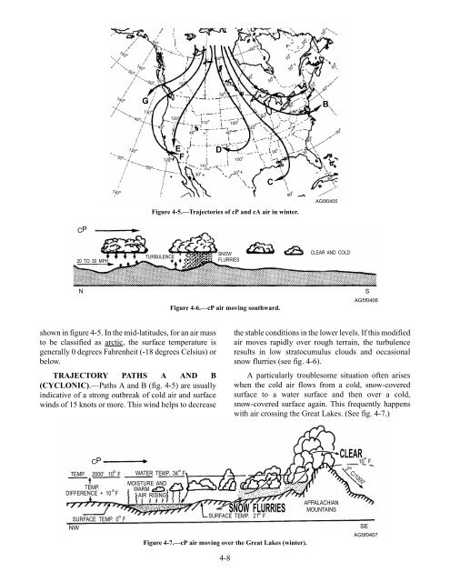
shown in figure 4-5. In the mid-latitudes, for an air mass<br />
to be classified as arctic, the surface temperature is<br />
generally 0 degrees Fahrenheit (-18 degrees Celsius) or<br />
below.<br />
TRAJECTORY PATHS A <strong>AND</strong> B<br />
(CYCLONIC).—Paths A and B (fig. 4-5) are usually<br />
indicative of a strong outbreak of cold air and surface<br />
winds of 15 knots or more. This wind helps to decrease<br />
140 O<br />
O 50O<br />
40 O<br />
130 O<br />
130 O<br />
60 O<br />
30 O 120 O<br />
40 O<br />
120 O<br />
40O<br />
110 O<br />
60 O<br />
50 O<br />
100 O<br />
40 O<br />
4-8<br />
100 O<br />
60 O<br />
40 O<br />
90 O<br />
70 O<br />
60 O<br />
50 O50O<br />
G B<br />
30 O<br />
120 O<br />
E<br />
F<br />
110 O<br />
D<br />
100 O<br />
30 O30O<br />
Figure 4-5.—Trajectories of cP and cA air in winter.<br />
TURBULENCE<br />
SNOW<br />
FLURRIES<br />
90 O<br />
60 O<br />
50 O<br />
C<br />
90 O<br />
80O<br />
90 O<br />
A<br />
30 O<br />
80 O<br />
70 O<br />
the stable conditions in the lower levels. If this modified<br />
air moves rapidly over rough terrain, the turbulence<br />
results in low stratocumulus clouds and occasional<br />
snow flurries (see fig. 4-6).<br />
A particularly troublesome situation often arises<br />
when the cold air flows from a cold, snow-covered<br />
surface to a water surface and then over a cold,<br />
snow-covered surface again. This frequently happens<br />
with air crossing the Great Lakes. (See fig. 4-7.)<br />
40 O<br />
80 O<br />
60 O<br />
AG5f0405<br />
30O<br />
CLEAR <strong>AND</strong> COLD<br />
N S<br />
CP<br />
O<br />
TEMP. 2000' 10 F<br />
TEMP. O<br />
DIFFERENCE + 10 F<br />
O<br />
SURFACE TEMP. 0 F<br />
NW<br />
O<br />
WATER TEMP. 34 F<br />
MOISTURE <strong>AND</strong><br />
WARM<br />
<strong>AIR</strong> RISING<br />
Figure 4-6.—cP air moving southward.<br />
SNOW FLURRIES<br />
O<br />
SURFACE TEMP. 21 F<br />
Figure 4-7.—cP air moving over the Great Lakes (winter).<br />
APPALACHIAN<br />
MOUNTAINS<br />
CLEAR<br />
3 C/1000'<br />
O<br />
AG5f0406<br />
O<br />
10 F<br />
SE<br />
AG5f0407