AIR MASSES AND FRONTS
AIR MASSES AND FRONTS
AIR MASSES AND FRONTS

Create successful ePaper yourself
Turn your PDF publications into a flip-book with our unique Google optimized e-Paper software.
Upper Air Characteristics<br />
If only one upper air sounding were taken so that it<br />
intersected either the cold or warm front, the sounding<br />
would appear as a typical warm or cold front sounding.<br />
However, if the sounding were taken so that it<br />
intersected both the cold and warm air, it would show<br />
two inversions.<br />
The occlusion may appear on some upper air<br />
charts. It usually appears on the 850-mb chart, but<br />
rarely on the 700-mb chart. As the two air masses are<br />
brought closer together and as the occlusion process<br />
brings about gradual disappearance of the warm sector,<br />
the isotherm gradient associated with the surface front<br />
weakens. The degree of weakening depends on the<br />
horizontal temperature differences between the cold air<br />
to the rear of the cold front and that ahead of the warm<br />
front. The angle at which the isotherms cross the<br />
surface position of the occluded fronts becomes greater<br />
as the temperature contrast between the two cold air<br />
lasses decreases. A typical illustration of the isotherms<br />
shows a packing of isotherms in the cold mass behind<br />
the cold front and less packing in the cool mass in<br />
advance of the warm front. A warm isotherm ridge<br />
precedes the occlusion aloft.<br />
WARM OCCLUSIONS<br />
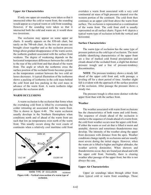
A warm occlusion is the occlusion that forms when<br />
the overtaking cold front is lifted by overrunning the<br />
colder retreating air associated with the warm front.<br />
This is shown in figure 4-40. The warm occlusion<br />
usually develops in the Northern Hemisphere when<br />
conditions north and of ahead of the warm front are<br />
such that low pa temperatures exist north of the warm<br />
front. This usually occurs along the west coasts of<br />
continents when a relatively cool maritime cold front<br />
COLD-FRONT SURFACE<br />
WARM <strong>AIR</strong><br />
WARM-FRONT SURFACE<br />
COLD <strong>AIR</strong> COLDER <strong>AIR</strong><br />
WARM TYPE OF OCCLUSION AG5f0440<br />
Figure 4-40.—Vertical cross-section of a warm type of<br />
occlusion.<br />
4-42<br />
overtakes a warm front associated with a very cold<br />
continental air mass of high pressure situated over the<br />
western portion of the continent. The cold front then<br />
continues as an upper cold front above the warm front<br />
surface. The occlusion is represented as a continuation<br />
of the warm front. The cold front aloft is usually<br />
represented on all surface charts. Figure 4-41 depicts a<br />
typical warm type of occlusion in both the vertical and<br />
horizontal.<br />
Surface Characteristics<br />
The warm type of occlusion has the same type of<br />
pressure pattern as the cold type of occlusion. The most<br />
reliable identifying characteristics of the upper front<br />
are a line of marked cold frontal precipitation and<br />
clouds ahead of the occluded front, a slight but distinct<br />
pressure trough and a line of pressure-tendency<br />
discontinuities.<br />
NOTE: The pressure tendency shows a steady fall<br />
ahead of the upper cold front and, with passage, a<br />
leveling off for a short period of time. Another slight<br />
fall is evident with the approach of the surface position<br />
of the occlusion. After passage the pressure shows a<br />
steady rise.<br />
The pressure trough is often more distinct with the<br />
upper front than with the surface front.<br />
Weather<br />
The weather associated with warm front occlusions<br />
has the characteristics of both warm and cold fronts.<br />
The sequence of clouds ahead of the occlusion is<br />
similar to the sequence of clouds ahead of a warm front;<br />
the cold front weather occurs near the upper cold front.<br />
If either the warm or cool air that is lifted is moist and<br />
unstable, showers and sometimes thunderstorms may<br />
develop. The intensity of the weather along the upper<br />
front decreases with distance from the apex. Weather<br />
conditions change rapidly in occlusions and are usually<br />
most severe during the initial stages. However, when<br />
the warm air is lifted to higher and higher altitudes, the<br />
weather activity diminishes. When showers and<br />
thunderstorms occur, they are found just ahead and with<br />
the upper cold front. Normally, there is clearing<br />
weather after passage of the upper front, but this is not<br />
always the case.<br />
Upper Air Characteristics<br />
Upper air soundings taken through either front<br />
show typical cold or warm front soundings. Those