AIR MASSES AND FRONTS
AIR MASSES AND FRONTS
AIR MASSES AND FRONTS

You also want an ePaper? Increase the reach of your titles
YUMPU automatically turns print PDFs into web optimized ePapers that Google loves.
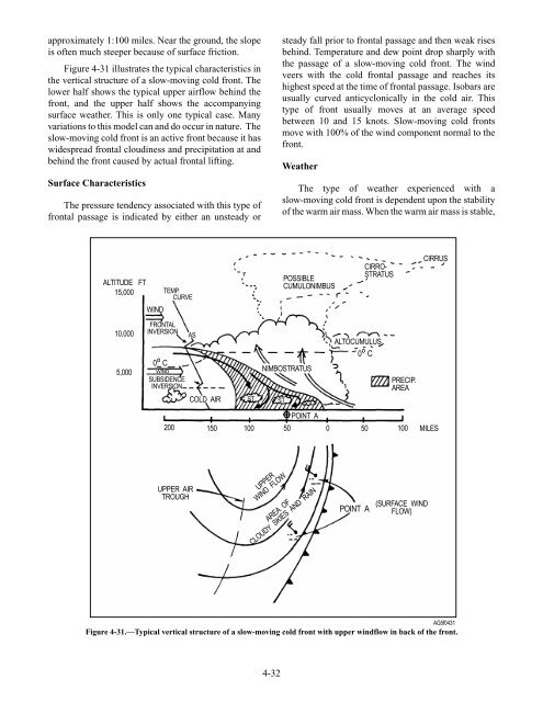
approximately 1:100 miles. Near the ground, the slope<br />
is often much steeper because of surface friction.<br />
Figure 4-31 illustrates the typical characteristics in<br />
the vertical structure of a slow-moving cold front. The<br />
lower half shows the typical upper airflow behind the<br />
front, and the upper half shows the accompanying<br />
surface weather. This is only one typical case. Many<br />
variations to this model can and do occur in nature. The<br />
slow-moving cold front is an active front because it has<br />
widespread frontal cloudiness and precipitation at and<br />
behind the front caused by actual frontal lifting.<br />
Surface Characteristics<br />
The pressure tendency associated with this type of<br />
frontal passage is indicated by either an unsteady or<br />
ALTITUDE FT<br />
15,000<br />
10,000<br />
5,000<br />
WIND<br />
FRONTAL<br />
INVERSION<br />
O<br />
0 C<br />
WIND<br />
TEMP.<br />
CURVE<br />
SUBSIDENCE<br />
INVERSION<br />
AS<br />
COLD <strong>AIR</strong><br />
4-32<br />
steady fall prior to frontal passage and then weak rises<br />
behind. Temperature and dew point drop sharply with<br />
the passage of a slow-moving cold front. The wind<br />
veers with the cold frontal passage and reaches its<br />
highest speed at the time of frontal passage. Isobars are<br />
usually curved anticyclonically in the cold air. This<br />
type of front usually moves at an average speed<br />
between 10 and 15 knots. Slow-moving cold fronts<br />
move with 100% of the wind component normal to the<br />
front.<br />
Weather<br />
The type of weather experienced with a<br />
slow-moving cold front is dependent upon the stability<br />
of the warm air mass. When the warm air mass is stable,<br />
POSSIBLE<br />
CUMULONIMBUS<br />
NIMBOSTRATUS<br />
ST ST<br />
POINT A<br />
CIRRO-<br />
STRATUS<br />
ALTOCUMULUS<br />
O<br />
0 C<br />
PRECIP.<br />
AREA<br />
CIRRUS<br />
200 150 100 50 0 50 100 MILES<br />
UPPER <strong>AIR</strong><br />
TROUGH<br />
UPPER<br />
WIND FLOW<br />
AREA OF<br />
CLOUDY SKIES <strong>AND</strong> RAIN<br />
POINT A<br />
(SURFACE WIND<br />
FLOW)<br />
AG5f0431<br />
Figure 4-31.—Typical vertical structure of a slow-moving cold front with upper windflow in back of the front.