Community-based Sectors for the New England Groundfish Fishery
Community-based Sectors for the New England Groundfish Fishery
Community-based Sectors for the New England Groundfish Fishery

You also want an ePaper? Increase the reach of your titles
YUMPU automatically turns print PDFs into web optimized ePapers that Google loves.
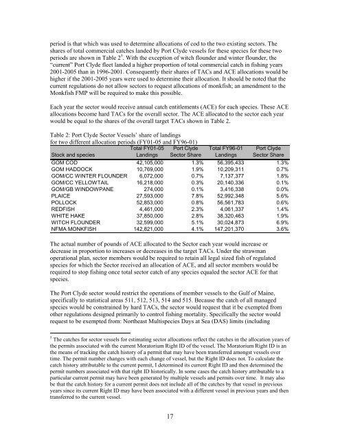
period is that which was used to determine allocations of cod to <strong>the</strong> two existing sectors. The<br />
shares of total commercial catches landed by Port Clyde vessels <strong>for</strong> <strong>the</strong>se species <strong>for</strong> <strong>the</strong>se two<br />
periods are shown in Table 2 5 . With <strong>the</strong> exception of witch flounder and winter flounder, <strong>the</strong><br />
“current” Port Clyde fleet landed a higher proportion of total commercial catch in fishing years<br />
2001-2005 than in 1996-2001. Consequently <strong>the</strong>ir shares of TACs and ACE allocations would be<br />
higher if <strong>the</strong> 2001-2005 years were used to determine <strong>the</strong>ir allocation. It should be noted that <strong>the</strong><br />
current regulations do not allow sectors to request allocations of monkfish; an amendment to <strong>the</strong><br />
Monkfish FMP will be required to make this possible.<br />
Each year <strong>the</strong> sector would receive annual catch entitlements (ACE) <strong>for</strong> each species. These ACE<br />
allocations become hard TACs <strong>for</strong> <strong>the</strong> overall sector. The ACE allocated to <strong>the</strong> sector each year<br />
would be equal to <strong>the</strong> shares of <strong>the</strong> overall target TACs shown in Table 2.<br />
Table 2: Port Clyde Sector Vessels’ share of landings<br />
<strong>for</strong> two different allocation periods (FY01-05 and FY96-01)<br />
Stock and species<br />
Total FY01-05<br />
Landings<br />
Port Clyde<br />
Sector Share<br />
Total FY96-01<br />
Landings<br />
Port Clyde<br />
Sector Share<br />
GOM COD 42,105,000 1.3% 56,395,433 1.3%<br />
GOM HADDOCK 10,769,000 1.9% 10,209,311 0.7%<br />
GOM/CC WINTER FLOUNDER 6,072,000 0.7% 7,137,377 1.8%<br />
GOM/CC YELLOWTAIL 16,218,000 0.3% 20,140,336 0.1%<br />
GOM/GB WINDOWPANE 274,000 0.1% 3,416,338 0.0%<br />
PLAICE 27,593,000 7.8% 52,992,348 5.6%<br />
POLLOCK 52,853,000 0.8% 56,561,783 0.6%<br />
REDFISH 4,461,000 2.3% 4,061,337 1.4%<br />
WHITE HAKE 37,850,000 2.8% 38,320,463 1.9%<br />
WITCH FLOUNDER 32,599,000 5.1% 30,024,873 6.9%<br />
NFMA MONKFISH 142,821,000 4.1% 147,201,370 3.6%<br />
The actual number of pounds of ACE allocated to <strong>the</strong> Sector each year would increase or<br />
decrease in proportion to increases or decreases in <strong>the</strong> target TACs. Under <strong>the</strong> strawman<br />
operational plan, sector members would be required to retain all legal sized fish of regulated<br />
species <strong>for</strong> which <strong>the</strong> Sector received an allocation of ACE, and all sector members would be<br />
required to stop fishing once total sector catch of any species equaled <strong>the</strong> sector ACE <strong>for</strong> that<br />
species.<br />
The Port Clyde sector would restrict <strong>the</strong> operations of member vessels to <strong>the</strong> Gulf of Maine,<br />
specifically to statistical areas 511, 512, 513, 514 and 515. Because <strong>the</strong> catch of all managed<br />
species would be constrained by hard TACs, <strong>the</strong> sector would request that it be exempted from<br />
o<strong>the</strong>r regulations designed primarily to control fishing mortality. Specifically <strong>the</strong> sector would<br />
request to be exempted from: Nor<strong>the</strong>ast Multispecies Days at Sea (DAS) limits (including<br />
5 The catches <strong>for</strong> sector vessels <strong>for</strong> estimating sector allocations reflect <strong>the</strong> catches in <strong>the</strong> allocation years of<br />
<strong>the</strong> permits associated with <strong>the</strong> current Moratorium Right ID of <strong>the</strong> vessel. The Moratorium Right ID is an<br />
<strong>the</strong> means of tracking <strong>the</strong> catch history of a permit that may have been transferred amongst vessels over<br />
time. The permit number changes with each change of vessel, but <strong>the</strong> Right ID does not. To calculate <strong>the</strong><br />
catch history attributable to <strong>the</strong> current permit, I determined its current Right ID and <strong>the</strong>n determined <strong>the</strong><br />
permit numbers associated with that right ID historically. In some cases <strong>the</strong> catch history attributable to a<br />
particular current permit may have been generated by multiple vessels and permits over time. It may also<br />
be that <strong>the</strong> catch history <strong>for</strong> a current permit does not include all of <strong>the</strong> catches by that vessel in previous<br />
years since its current Right ID may have been associated with a different vessel in previous years and <strong>the</strong>n<br />
transferred to <strong>the</strong> current vessel.<br />
17